
Lillooet, formerly Cayoosh Flat, is a community on the Fraser River in British Columbia, Canada, about 240 kilometres (150 mi) up the British Columbia Railway line from Vancouver. Situated at an intersection of deep gorges in the lee of the Coast Mountains, it has a dry climate with an average of 329.5 millimetres (13 in) of precipitation being recorded annually. Lillooet has a long growing season, and once had prolific market gardens and orchard produce. It often vies with Lytton and Osoyoos for the title of "Canada's Hot Spot" on a daily basis in summer.

The Grand Trunk Pacific Railway was a historical Canadian transcontinental railway running from Winnipeg to the Pacific coast at Prince Rupert, British Columbia. East of Winnipeg the line continued as the National Transcontinental Railway (NTR), running across northern Ontario and Quebec, crossing the St. Lawrence River at Quebec City and ending at Moncton, New Brunswick. The Grand Trunk Railway (GTR) managed and operated the entire line.

The Canadian Northern Railway (CNoR) is a historic Canadian transcontinental railway. At its demise in 1923, when it was merged into the Canadian National Railway, the CNoR owned a main line between Quebec City and Vancouver via Ottawa, Winnipeg, and Edmonton.

The Thompson River is the largest tributary of the Fraser River, flowing through the south-central portion of British Columbia, Canada. The Thompson River has two main branches, the South Thompson River and the North Thompson River. The river is home to several varieties of Pacific salmon and trout. The area's geological history was heavily influenced by glaciation, and the several large glacial lakes have filled the river valley over the last 12,000 years. Archaeological evidence shows human habitation in the watershed dating back at least 8,300 years. The Thompson was named by Fraser River explorer, Simon Fraser, in honour of his friend, Columbia Basin explorer David Thompson. Recreational use of the river includes whitewater rafting and angling.

Lytton in British Columbia, Canada, sits at the confluence of the Thompson River and Fraser River on the east side of the Fraser. The location has been inhabited by the Nlaka'pamux people for over 10,000 years. It is one of the earliest locations settled by non-natives in the Southern Interior of British Columbia. It was founded during the Fraser Canyon Gold Rush of 1858–59, when it was known as "The Forks". The community includes the Village of Lytton and the surrounding community of the Lytton First Nation, whose name for the place is Camchin, also spelled Kumsheen.
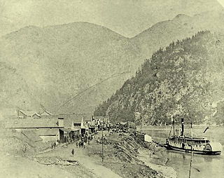
Yale is an unincorporated town in the Canadian province of British Columbia.

The Fraser Canyon is a major landform of the Fraser River where it descends rapidly through narrow rock gorges in the Coast Mountains en route from the Interior Plateau of British Columbia to the Fraser Valley. Colloquially, the term "Fraser Canyon" is often used to include the Thompson Canyon from Lytton to Ashcroft, since they form the same highway route which most people are familiar with, although it is actually reckoned to begin above Williams Lake, British Columbia at Soda Creek Canyon near the town of the same name.

Skihist Provincial Park is a provincial park in British Columbia, Canada, located on the Thompson River and adjacent to the Trans-Canada Highway #1 between the towns of Lytton (W) and Spences Bridge (E). The park is named for Skihist Mountain, which is visible from the park though on the opposite side of the Fraser River to the west of Lytton.
Spences Bridge is a community in the Canadian province of British Columbia, situated 35 km north east of Lytton and 44 km south of Ashcroft. In 1892, the population included 32 people of European ancestry and 130 First Nations people. There were five general stores, three hotels, one Church of England and one school. The principal industries are fruit growing and farming. The population as of 2016 is 99.
The British Columbia Interior, BC Interior or Interior of British Columbia, usually referred to only as the Interior, is one of the three main regions of the Canadian province of British Columbia, the other two being the Lower Mainland, which comprises the overlapping areas of Greater Vancouver and the Fraser Valley, and the Coast, which includes Vancouver Island and also including the Lower Mainland.
The Siska First Nation is a Nlaka'pamux First Nations government located in the Fraser Canyon region of the Canadian province of British Columbia. It is a member of the Nicola Tribal Association, which are two of three tribal councils of the Nlaka'pamux people. Other Nlaka'pamux governments belong either to the Fraser Canyon Indian Administration or the Nlaka'pamux Nation Tribal Council, although the large Lytton First Nation, north of Siska, does not belong to any of the three.

Skuzzy was a sternwheeler built by Canadian Pacific Railway contractor Andrew Onderdonk at Spuzzum, British Columbia, and was launched on the Fraser River on May 4, 1882.
Skuzzy was the first sternwheeler to ever navigate the perilous rapids north of Yale in the Fraser Canyon.

Lytton was a sternwheel steamboat that ran on the Arrow Lakes and the Columbia River in southeastern British Columbia and northeastern Washington from 1890 to 1904.

Siska, also known historically as Cisco, is a locality in the Fraser Canyon of British Columbia, Canada 9.4 kilometres south of the town of Lytton. It is at Siska that the Canadian Pacific and Canadian National Railways switch from one side of the river to the other, due to the impossibility of both railways occupying the same bank of the Fraser due to the narrow and steep terrain. The resulting pair of bridges, with the CNR bridge just upstream of the CPR's, and the CPR's bridge's west foot entering the Cantilever Bar Tunnel into the side of Cisco Bluff, remains one of the most famous images of the CPR's route through British Columbia today and is easily viewable from the adjacent Trans-Canada Highway.
The Lytton CNR Thompson Bridge is a deck truss bridge carrying the Canadian National Railway tracks from across the Thompson River at Lytton, British Columbia, approximately 200 meters (660 ft) upstream of where the Thompson River merges into the Fraser River. It is of a similar design and should not be confused with the Lytton CNR Fraser Bridge located approximately 1.4 kilometers (0.87 mi) south. It consists of 3 deck Pratt truss spans which are supported on four concrete piers. The centre two piers are in the river while the outer two are shorter and above the waterline. British Columbia Highway 12 crosses the Thompson River mostly parallel to, and slightly downstream of this bridge. The south end of the road bridge is directly above the south end of the railroad bridge.
