
The Regional Municipality of York, also called York Region, is a regional municipality in Southern Ontario, Canada, between Lake Simcoe and Toronto. The region was established after the passing of then Bill 102, An Act to Establish The Regional Municipality of York, in 1970. It replaced the former York County in 1971, and is part of the Greater Toronto Area and the inner ring of the Golden Horseshoe. The regional government is headquartered in Newmarket.

Whitchurch-Stouffville is a town in the Greater Toronto Area of Ontario, Canada, approximately 50 km (31 mi) north of downtown Toronto, and 55 km (34 mi) north-east of Toronto Pearson International Airport. It is 206.22 km2 (79.62 sq mi) in area, and located in the mid-eastern area of the Regional Municipality of York on the ecologically-sensitive Oak Ridges Moraine. Its motto since 1993 is "country close to the city".
Stouffville is the primary urban area within the town of Whitchurch-Stouffville in the York Region of Ontario, Canada. It is situated within the Greater Toronto Area and the inner ring of the Golden Horseshoe. The urban area is centred at the intersection of Main Street, Mill Street, and Market Street. Between 2006 and 2011, the population of the Community of Stouffville grew 100.5% from 12,411 to 24,886, or from 51% to 66% of the total population of the larger town of Whitchurch-Stouffville.

Musselman's Lake is a community settled adjacent to a 118-acre (0.48 km2) kettle lake of the same name in the town of Whitchurch–Stouffville, Ontario, Canada. It is located about 6 km north-northwest of urban Stouffville, and is part of the Greater Toronto Area.

Stouffville GO Station is a railway station in the GO Transit network located in Stouffville, Ontario, Canada. It was the northern terminus of the Stouffville line train service until the line was extended to Lincolnville on September 2, 2008. Buses serve the station from stops on the street due to space limitations.

The history of Markham, Ontario dates back several millennia. What would become Markham, Ontario was home to First Nations long before European settlement. Seasonal settlements were found from 900 BC to 1650, but traces of these first residence were buried before the area was farmed.
Markham—Stouffville is a federal electoral district in Ontario, Canada. It encompasses a portion of Ontario previously included in the electoral districts of Markham—Unionville and Oak Ridges—Markham.

Bogarttown is a community located at Mulock Drive and Leslie Street between Bayview Avenue and Woodbine Avenue in York Region, Ontario, Canada. Formerly a distinct rural hamlet, it is now a part of the Town of Newmarket, Ontario both administratively and more recently geographically owing to sprawling suburban development. The name is occasionally seen misspelled as Bogartown.
The East Holland River is a river in Ontario, Canada that is part of the Holland River watershed that empties into Cook's Bay in Lake Simcoe. The headwaters of the East Holland River rise in the Oak Ridges Moraine. The river runs generally north from the town of Newmarket, and through Holland Landing where it joins up with the West Holland River.
Ballantrae, Ontario is a hamlet in the Town of Whitchurch–Stouffville. Named after the village of Ballantrae in South Ayrshire, Scotland, the community is centred on the intersection of Aurora Road and Highway 48.
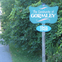
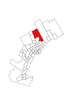
Gormley is a hamlet in York Region, Ontario, Canada that overlaps parts of Richmond Hill, and Whitchurch–Stouffville, two municipalities within the Greater Toronto Area. It was divided into two parts due to the construction of Highway 404. A portion of Gormley situated within Richmond Hill's political boundaries is subject to "Heritage Conservation District" controls. A post office in Gormley (East) serves as the mailing address for the Whitchurch–Stouffville communities of Bethesda, Gormley, Preston Lake, Vandorf, and Wesley Corners.
Dickson Hill is a small community in northeast Markham, Ontario, Canada, located near Highway 48 and 19th Avenue, on the border to Whitchurch-Stouffville.
Vandorf is a hamlet located in the town of Whitchurch–Stouffville, Ontario, in Canada. It is the most westerly settlement within the Town of Whitchurch-Stouffville. With a population of approximately 722, Vandorf consists mainly of estate residential homes and farms.
Cashel, Ontario is a small hamlet situated in Unionville, Ontario located at the intersection of Elgin Mills Road and York Regional Road 67. Originally it was called Crosby Corners after John Crosby, the village's first store owner, who came originally from New York State. The name was changed to Cashel in 1851 with the opening of its first post office. It was likely named after Cashel in Ireland. In 1851 the community had a sawmill, cobbler shop, blacksmith shop, wagon shop, inn and tavern, Masonic Lodge, and Presbyterian church. In 1890 Peaches United Church was built on land from farmer Thomas Peach at 10762 McCowan Road. The church is a historic site and not operating since the 1960s to 1970s, but cemetery remains in active use. The east west sideroad along the church was locally called Peaches (Peach's) Sideroad or otherwise known as Elgin Mills Road.
Preston Lake is a community located in the town of Whitchurch–Stouffville in the Regional Municipality of York in Ontario, Canada. The community is centred on Preston Lake, a natural glacier kettle lake, immediately north-east of the intersection of Bloomington Road and Woodbine Avenue, east of Highway 404, near Aurora.

CIWS-FM is a Canadian radio station, which broadcasts a community radio format on 102.9 FM in Whitchurch–Stouffville, Ontario.

Gormley GO Station is a train and bus station in the GO Transit network located in Richmond Hill, Ontario, Canada, serving Oak Ridges and the Whitchurch–Stouffville community of Gormley. It was the terminus of the Richmond Hill line train service from when it opened on 5 December 2016 until 28 June 2021, when the line was extended north to Bloomington GO Station.
Markham—Stouffville is a provincial electoral district in Ontario. It encompasses a portion of Ontario formerly included in the electoral districts of Markham—Unionville and Oak Ridges—Markham.
CNR Bridge is a swing railway bridge over the Fraser River in New Westminster, British Columbia, Canada.


