The Trenton area is part of the traditional area of the Mississauga and other Indigenous First Nations. The first known expedition by Europeans in the area was one by French explorer Samuel de Champlain, which followed the Trent passing through Trenton in 1615. The Trent River is known to the Mississauga as Sangichiwigewonk, or 'fast flowing.' Settlers gave it the name 'Trent', after the River Trent in England.
The area around the mouth of the Trent River was first settled by Europeans in the 1780s, after the area was ceded to the British in 1783 as part of the Crawford Purchase. United Empire Loyalists first settled in Trenton in 1792. First named Trent Port, it was renamed Trent Town and later became Trenton. Assorted settlements and town plots in the area went under a number of names until the Village of Trenton was incorporated in 1853. Trenton grew thanks to its port location and the area's lumber industry. During the First World War, the town was home to a major munitions plant owned by the British Chemical Company. This facility was built in 1915 to manufacture artillery, rifle, and small arms ammunition. Three weeks before the Armistice, an explosion levelled the plant. Remains of the old plant can still be found today.
Trenton was also an important film production centre. In 1917, a film studio was built in the town and a number of productions were filmed there.[2] In 1923, the Trenton Film Plant was purchased by the Ontario government to house the studio and laboratory of the Ontario Motion Picture Bureau.[2] The advent of talkies and 16mm film made the equipment at the film plant obsolete and the facility closed in 1934.[2]
Trenton Town annexed parts of Sidney Township in 1964 and parts of Murray Township in Northumberland County in 1964 and 1968.[1]
Trenton was incorporated as a city in 1980. On January 1, 1998, Trenton was amalgamated with the Village of Frankford and the Townships of Murray and Sidney to form Quinte West.[3] Home to nearly half the population of Quinte West, Trenton is the largest community within the municipality, and is one of Ontario's largest unincorporated settlements.
Demographics
Historical census populations – Trenton, Ontario
Year
Pop.
±%
1871
1,796
—
1881
3,042
+69.4%
1891
4,363
+43.4%
1901
4,217
−3.3%
1911
3,988
−5.4%
1921
5,902
+48.0%
1931
6,276
+6.3%
Year
Pop.
±%
1941
8,323
+32.6%
1951
10,085
+21.2%
1956
11,492
+14.0%
1961
13,183
+14.7%
1966
13,746
+4.3%
1971
14,589
+6.1%
1976
15,476
+6.1%
Year
Pop.
±%
1981
15,085
−2.5%
1986
15,311
+1.5%
1991
16,908
+10.4%
1996
17,179
+1.6%
2001
16,770
−2.4%
Population counts are not adjusted for boundary changes. Source: Statistics Canada[1][4][5]
Economy
Canadian Forces Base Trenton/8 Wing, located on the east side of the town, is an important facility for the Royal Canadian Air Force's transport and search and rescue operations, and is Trenton's main employer.
Other large employers include Trenton Cold Storage,[6]Norampac, Kruger, Mapco, Citipack, Jobsters, Pentair Thermal Controls, Nestlé, ElectroCables, Domtech, Global Med Inc., Mckesson Canada and DECA Cables.
Tourism also plays an important role in the economy, given Trenton's location as the southern entry point for the Trent–Severn Waterway.
From 1917 to 1920, The Parker Bros. Textile Mill was a movie studio, which dubbed Trenton "Hollywood North".[2]
Transportation
Dundas Street, the main road in Trenton
Highway 401 crosses the Trent River on the north side of the town. Hastings County Road 2 (formerly Ontario Highway 2) is the main east–west route through town, leading towards Brighton in the west and to Belleville in the east. The main north–south route is Hastings County Road 33 (formerly Ontario Highway 33), leading towards Picton to the south and Stirling to the north.
Trenton Airport is co-located with CFB Trenton on the east side of town.
Trenton is the starting point for the Trent–Severn Waterway and two locks (Lock 1 and Lock 2) are located in the community.[7]
Trenton also has a local public transit system, run by Quinte Access. It runs an hourly schedule Monday to Friday and limited service on Saturday (no Sunday Service, check for holidays) with Chevrolet Arboc specialized buses with ramps for wheelchairs. Several private firms also provide dispatched taxi services.
Climate
Climate data for Trenton (1991–2020 normals, extremes 1921–present)[8]
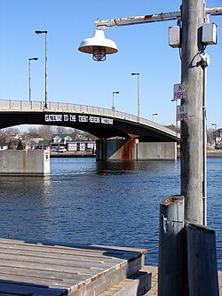
Trenton is the gateway to the Trent-Severn Waterway
Trenton is located on the Lake Ontario Waterfront Trail. Surrounding Trenton, there are numerous conservation areas, a YMCA, campsites, picnic grounds, and marinas. The area has nine golf courses, three ice hockeyrinks, numerous soccer fields, bowling, many kilometres of walking trails, a dog park, curling rinks and baseball diamonds, amongst many other recreational activities. Trenton also serves as a gateway to Prince Edward County, south of the Bay of Quinte. This area is becoming increasingly well known for its vineyards, camping, beaches and boating.
Trenton is the site of the National Air Force Museum of Canada. It features an original RAF Halifax Bomber, the 75th RCAF time capsule, a Lockheed CC-130E Hercules, and many other aircraft and exhibits. The museum is presently restoring an Avro Lancaster bomber.
Every summer CFB Trenton also is home to over one thousand Royal Canadian Air Cadets who attend two-week Familiarization Courses, three-week Introductory Specialty Courses, and six-week Advanced Specialty Courses, and has special staff positions for more senior cadets. These summer courses introduce the cadets to a military learning environment. Most camps here also go on trips to the airport, the Air Museum, and other relevant places.
Trenton is a hot spot for sport fishing. Popular freshwater fish in the Bay of Quinte and the Trent River include walleye (pickerel), bass, pike, perch, and mudcat. During particular times of the year, salmon and rainbow trout can be caught in the Trent River and in cold-water streams in the area. Each year in May, the Kiwanis Club of Trenton holds the Annual Live Release Fishing Derby, attracting thousands of sport fishermen from around North America with major prizes for tagged fish and heaviest weighed walleye and Northern pike.
In 1990, Canadian poet Al Purdy (who received the Order of Canada and the Governor General's award) published his only novel A Splinter In The Heart. It takes place entirely in Trenton and provides a historical look at the town. It mentions many of the landmarks in the city (Mount Pelion, The Bridges, Trent River, etc.) and documents the period of the town directly before and after the huge munitions plant explosion of 1918. Purdy also wrote a poem entitled "At the Quinte Hotel" about the strip club in Trenton called The Sherwood Forest Inn.[11]
Another thing that Trenton is known for is its great swimming, fishing and boating. In addition it is known for being the capital of walleye fishing.
This page is based on this Wikipedia article Text is available under the CC BY-SA 4.0 license; additional terms may apply. Images, videos and audio are available under their respective licenses.