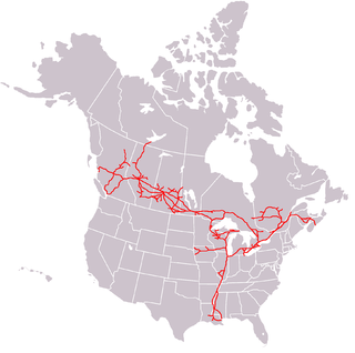
The Canadian National Railway Company is a Canadian Class I freight railway headquartered in Montreal, Quebec, which serves Canada and the Midwestern and Southern United States.

The Lethbridge Viaduct, commonly known as the High Level Bridge, is a railway trestle bridge over the Oldman River in Lethbridge, Alberta, Canada. Constructed between 1907 and 1909 by the Canadian Pacific Railway, it is the largest railway structure in Canada and the largest of its type in the world, and is still regularly maintained and used over a century since its construction.

The Island Corridor, previously the Esquimalt & Nanaimo Railway, is a railway operation on Vancouver Island. It is owned by the Island Corridor Foundation, a registered charity. The railway line is 225 kilometres (140 mi) in length from Victoria to Courtenay, known as the Victoria Subdivision, with a branch line from Parksville to Port Alberni, known as the Port Alberni Subdivision, of 64 kilometres (40 mi), for a total 289 kilometres (180 mi) of mainline track. In 2006, the Island Corridor Foundation acquired the railway's ownership from RailAmerica and Canadian Pacific Railway.
The National Transcontinental Railway (NTR) was a historic railway between Winnipeg, Manitoba, and Moncton, New Brunswick, in Canada. Much of the line is now operated by the Canadian National Railway.

The Fraser Canyon is a major landform of the Fraser River where it descends rapidly through narrow rock gorges in the Coast Mountains en route from the Interior Plateau of British Columbia to the Fraser Valley. Colloquially, the term "Fraser Canyon" is often used to include the Thompson Canyon from Lytton to Ashcroft, since they form the same highway route which most people are familiar with, although it is actually reckoned to begin above Williams Lake at Soda Creek Canyon near the town of the same name.

The Clear Range is a small mountain range located in the angle of the Fraser and Thompson Rivers in south-central British Columbia, Canada. It has a small subdivision just northeast of that confluence named the Scarped Range. The Clear Range totals 16,270 km2 (6,280 sq mi) and is 75 km (47 mi) north to south and 35 km (22 mi) east to west. The Clear Range and its northward neighbour the Marble Range are both subranges of the Pavilion Range.

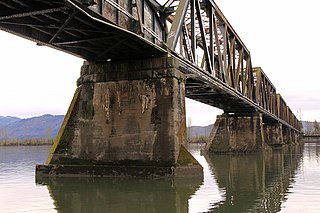
Opened in 1931, the Canadian National Railway (CNR) steel truss swing span railway bridge over the north arm of the Fraser River in Metro Vancouver links Burnaby with Richmond and the south arm Vancouver Fraser Port Authority facilities on Lulu Island.

The Marpole CP Rail Bridge was a partially dismantled crossing over the north arm of the Fraser River, and River Dr., in Metro Vancouver.
The Siska Indian Band is located in the Fraser Canyon region of the Canadian province of British Columbia. It was previously a member of the Scw’exmx Tribal Council, which is a tribal council of the Nlaka'pamux people. Other Nlaka'pamux governments belong either to the Fraser Canyon Indian Administration or the Nlaka'pamux Nation Tribal Council, although the large Lytton First Nation, north of Siska, does not belong to any of the three.

The Fredericton Railway Bridge is a former railway bridge in Fredericton, New Brunswick, Canada now used to carry pedestrians and cyclists.
The Mission Railway Bridge is a Canadian Pacific Railway bridge spanning the Fraser River between Mission, and Abbotsford, British Columbia, Canada.

Lytton was a sternwheel steamboat that ran on the Arrow Lakes and the Columbia River in southeastern British Columbia and northeastern Washington from 1890 to 1904.

Siska, also known historically as Cisco, is a locality in the Fraser Canyon, 9.4 kilometres south of the town of Lytton, British Columbia, Canada. It is at Siska that the Canadian Pacific and Canadian National Railways switch from one side of the river to the other, because it is impossible for both rail lines to occupy the same bank of the Fraser, due to the narrow and steep terrain. The resulting pair of bridges, with the CNR bridge just upstream of the CPR's, and the CPR's bridge's west foot entering the Cantilever Bar Tunnel into the side of Cisco Bluff, remains one of the most famous images of the CPR's route through British Columbia today and is easily viewable from the adjacent Trans-Canada Highway.

The Kettle Falls Bridges is the collective name for a pair of steel cantilever bridges carrying State Route 20/U.S. Route 395 and the Kettle Falls International Railway across the Columbia River at Kettle Falls, Washington. The south bridge carries motor vehicle traffic while the similar northern span is used for rail.
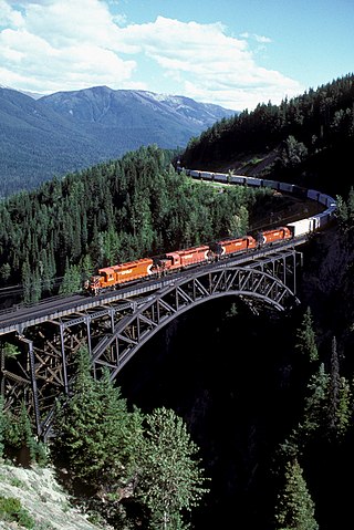
Stoney Creek Bridge is a Canadian Pacific Railway (CP) truss arch in southeastern British Columbia. This single-track crossing over Stoney Creek is in Glacier National Park, between Revelstoke and Golden.

The Lytton CNR Thompson Bridge is a deck truss bridge carrying the Canadian National Railway tracks from across the Thompson River at Lytton, British Columbia, approximately 200 meters (660 ft) upstream of where the Thompson River merges into the Fraser River. It is of a similar design and should not be confused with the Lytton CNR Fraser Bridge located approximately 1.4 kilometers (0.87 mi) south. It consists of 3 deck Pratt truss spans which are supported on four concrete piers. The centre two piers are in the river while the outer two are shorter and above the waterline. British Columbia Highway 12 crosses the Thompson River mostly parallel to, and slightly downstream of this bridge. The south end of the road bridge is directly above the south end of the railroad bridge.

The Lytton CNR Fraser Bridge is a deck truss bridge carrying the Canadian National Railway tracks across the Fraser River at Lytton, British Columbia. It is of a similar design to the Lytton CNR Thompson Bridge, located approximately 1.4 kilometers (0.87 mi) north. The bridge consists of three deck Pratt truss spans; the centre span measures approximately 90 metres, and each side span measures approximately 45 metres. The approach at either end is a pair of deck plate girder spans of approximately 20m each. The three centre truss spans are supported on four concrete piers. At each end, the approach girder spans are supported on the abutments, a taller and thinner concrete pier, and the truss spans. The Fraser River's water level varies dramatically throughout the year; the centre piers can be fully surrounded by rushing water in the spring and completely on dry land in late summer and fall. A pedestrian walkway on the north side of the bridge serves Indian reserve communities and other rural residents on the west side of the Fraser River.
CNR Bridge is a swing railway bridge over the Fraser River in New Westminster, British Columbia, Canada.

The Dubbo rail bridge over Macquarie River – Wambuul is a heritage-listed railway bridge on the Main Western line across the Macquarie River, located west of the Dubbo central business district in New South Wales, Australia. It was designed by John Whitton as the Engineer-in-Chief for the New South Wales Government Railways. The bridge was built during 1884 by Benjamin Barnes, with ironwork by Cochrane & Co, Middlesborough, England. The railway bridge is also known as the Dubbo Lattice Railway Bridge. The property is owned by Transport Asset Holding Entity, an agency of the Government of New South Wales. The bridge was added to the New South Wales State Heritage Register on 2 April 1999 and was listed on the Register of the National Estate on 18 April 1989.

Emu Plains Underbridge is a heritage-listed steel truss railway underbridge located off Bruce Neale Dr approximately 1.3 kilometres (0.81 mi) west of the Penrith railway station in the western Sydney suburb of Penrith in the City of Penrith local government area of New South Wales, Australia. It was designed by James Fraser, the existing lines branch and the New South Wales Government Railways. It was built in 1907, with fabrication by R. Tulloch & Co.; and erection by day labour. It is also known as Emu Plains Underbridge and Penrith Underbridge. The property is owned by Transport Asset Holding Entity, an agency of the Government of New South Wales. It was added to the New South Wales State Heritage Register on 28 June 2013.


