
Union Station is a major railway station and intermodal transportation hub in Toronto, Ontario, Canada. It is located on Front Street West, on the south side of the block bounded by Bay Street and York Street in downtown Toronto. The municipal government of Toronto owns the station building while the provincial transit agency Metrolinx owns the train shed and trackage. Union Station has been a National Historic Site of Canada since 1975, and a Heritage Railway Station since 1989. It is operated by the Toronto Terminals Railway, a joint venture of the Canadian National Railway and Canadian Pacific Railway that directs and controls train movement along the Union Station Rail Corridor, the largest and busiest rail corridor in Canada.

The Toronto waterfront is the lakeshore of Lake Ontario in the city of Toronto, Ontario, Canada. It spans 46 kilometres between the mouth of Etobicoke Creek in the west and the Rouge River in the east.

Front Street is an east–west road in downtown Toronto, Ontario, Canada. First laid out in 1796, the street is one of the original streets of the Town of York. The street was laid out along the shoreline of Lake Ontario as it existed during that time. It remains an important street, with many important uses located along it, including the St. Lawrence Market, Meridian Hall, Union Station and the Metro Toronto Convention Centre. The eastern section of Front Street, in the West Don Lands, east of Cherry Street, is being rebuilt as a broad tree-lined boulevard, intended to be the pedestrian-friendly commercial spine of the new neighbourhood.

The Distillery District is a commercial and residential district in Toronto, Ontario, Canada, east of downtown, which contains numerous cafés, restaurants, and shops housed within heritage buildings of the former Gooderham and Worts Distillery. The 13 acres (5.3 ha) district comprises more than forty heritage buildings and ten streets, and is the largest collection of Victorian-era industrial architecture in North America.

Napanee station in Napanee, Ontario, Canada is served by Via Rail trains running from Toronto to Ottawa. The 1856 limestone railway station was an unstaffed but heated shelter with telephones and washrooms, which would open at least half an hour before a train arrives. The platform is wheelchair-accessible. As of February 2023, the shelter was locked.

The West Don Lands are the site of a neighbourhood under construction in Toronto, Ontario, Canada. The area is bordered by the Don River, King Street, Parliament Street and the rail line adjacent to the Gardiner Expressway. It is 80 hectares in size. A former industrial area, the area is being rebuilt as a mixed-use neighbourhood.
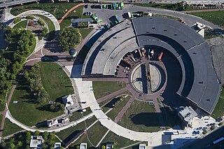
Roundhouse Park is a 17 acre park in the downtown core of Toronto, Ontario, Canada. It is in the former Railway Lands. It features the John Street Roundhouse, a preserved locomotive roundhouse which is home to the Toronto Railway Museum, Steam Whistle Brewing, and the restaurant and entertainment complex The Rec Room. The park is also home to a collection of trains, the former Canadian Pacific Railway Don Station, and the Roundhouse Park Miniature Railway. The park is bounded by Bremner Boulevard, Lower Simcoe Street, Lake Shore Boulevard West/Gardiner Expressway and Rees Street.

Railway Lands is an area in Downtown Toronto, Ontario, Canada. Originally a large railway switching yard near the Toronto waterfront, including the CNR Spadina Roundhouse and the CPR John Roundhouse, it has since been redeveloped and today is home to mostly mixed-used development, including the CN Tower and the Rogers Centre. The lands were owned and maintained by the Canadian National Railway and later transferred to the federal crown corporation Canada Lands Company. The area is bounded by Front Street, Yonge Street, Gardiner Expressway and Bathurst Street. The western portion of the Railway Lands is now part of the CityPlace neighbourhood and the eastern portion is now called South Core.
Cherry Street is a north-south arterial roadway in the eastern downtown of Toronto, Ontario, Canada. It is situated in a former industrial area, that is now the site of redevelopment. It connects Eastern Avenue south to Lake Shore Boulevard, then to the Toronto Port Lands district, and terminates at Lake Ontario at Cherry Beach.

The Cherry Street lift bridge over the Keating Channel is the smaller of two bascule lift bridges on Cherry Street, in Toronto, Ontario, Canada. The bridge spans the canalized mouth of the Don River where it empties into Toronto Harbour. It is the fourth bridge at that location.

West Harbour GO Station is a regional rail station in the North End neighbourhood of Hamilton, Ontario, Canada. The station has been served by GO Transit's Lakeshore West line since July 9, 2015. There is hourly service between West Harbour and Toronto's Union Station, seven days a week. Via Rail service may eventually be provided.

LIUNA Station is a banquet and convention centre in central Hamilton, Ontario. The building opened in 1931 as Hamilton C.N.R. Station and served as a passenger and freight railway station.
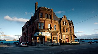
The Cherry Street Hotel is an 1859 heritage building in Toronto, Ontario, Canada. It is located on the southeast corner of Front Street and Cherry Street, in the West Don Lands neighbourhood. The structure was originally the Palace Street School, which closed in 1887. The building was converted into a hotel, and later became an industrial building housing small industry. In the 1960s, the Canary Restaurant opened. The building became a type of incubator, renting small spaces for artists and small businesses. The restaurant closed after the area around the building was demolished for the new West Don Lands community. The building has been integrated into the new community and its facade retained and restored. Its next use has not been announced.

The Don Mills Trail is a 3-kilometre (1.9 mi) cycling and walking trail in Toronto, Ontario, Canada. The trail runs south from York Mills Road, east of and roughly parallel to Leslie Street. The city built the trail on the roadbed of a former railway line, known as the Leaside Spur.

The Canary District is a housing development in Toronto's West Don Lands mixed-use development. Six initial buildings initially served as the 2015 Pan American Games Athletes' Village for the 2015 Pan American Games. Those buildings were then finished and converted to private residences. Dozens of further buildings will be constructed for private residences, with Front Street lined with boutiques and restaurants.

The Athlete's village for the 2015 Pan American Games and 2015 Parapan American Games cost $735 million CAD and had the capacity to hold up to 7,200 athletes and officials. After the games the village was converted to 746 market priced condos, 41 market-priced town homes, 250 affordable-rent apartments, 257 student dormitory units for George Brown College, office and retail units, and a YMCA recreation centre. The Athlete's Village was located in the West Don Lands along Front Street between Bayview Avenue and Cherry Street in Toronto. The development was certified LEED Gold. Five satellite villages were also used to house athletes that were competing in venues far from the main village.
Draper Street is a street in downtown Toronto, Ontario, Canada. It is a north-south street located to the west of Spadina Avenue, from Front Street West north to Wellington Street. Draper Street is notable for its collection of 28 nineteenth-century row cottages of the Second Empire style. They were designated by the City of Toronto government in the 1990s to have heritage status. The entire street is designated as a Heritage Conservation District as a way to preserve its heritage for posterity.

Villiers Island is a 22-hectare (54-acre) area in Toronto's Port Lands being converted to an island. The project is a part of Port Lands Flood Protection Project by Waterfront Toronto. To prevent flooding from the Don River, a channel is being created to extend the river south and then west into Toronto Harbour providing another outlet and a more natural mouth for the Don River. The new channel effectively creates the island, which is also bounded by the Keating Channel and Toronto Harbour. Mixed-use residential development is planned for Villiers Island.
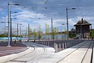
Distillery Loop is a streetcar loop in the Toronto streetcar system in Toronto, Ontario, Canada that lies at the south end of the Cherry Street branch – originally dubbed the Cherry Street streetcar line – that runs from a streetcar junction on King Street East south along Sumach and Cherry Streets. The loop opened in June 2016 and is some of the newer streetcar infrastructure in the city. The Cherry Street branch is currently served by the 504A King streetcar route which has its eastern terminus at Distillery Loop.


