Related Research Articles

Aerobiology is a branch of biology that studies the passive transport of organic particles, such as bacteria, fungal spores, very small insects, pollen grains and viruses. Aerobiologists have traditionally been involved in the measurement and reporting of airborne pollen and fungal spores as a service to those with allergies. However, aerobiology is a varied field, relating to environmental science, plant science, meteorology, phenology, and climate change.
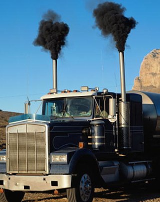
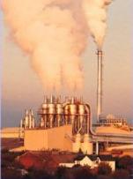
Exhaust gas or flue gas is emitted as a result of the combustion of fuels such as natural gas, gasoline (petrol), diesel fuel, fuel oil, biodiesel blends, or coal. According to the type of engine, it is discharged into the atmosphere through an exhaust pipe, flue gas stack, or propelling nozzle. It often disperses downwind in a pattern called an exhaust plume.
CHEMKIN is a proprietary software tool for solving complex chemical kinetics problems. It is used worldwide in the combustion, chemical processing, microelectronics and automotive industries, and also in atmospheric science. It was originally developed at Sandia National Laboratories and is now developed by a US company, Reaction Design.

In hydrodynamics, a plume or a column is a vertical body of one fluid moving through another. Several effects control the motion of the fluid, including momentum (inertia), diffusion and buoyancy. Pure jets and pure plumes define flows that are driven entirely by momentum and buoyancy effects, respectively. Flows between these two limits are usually described as forced plumes or buoyant jets. "Buoyancy is defined as being positive" when, in the absence of other forces or initial motion, the entering fluid would tend to rise. Situations where the density of the plume fluid is greater than its surroundings, but the flow has sufficient initial momentum to carry it some distance vertically, are described as being negatively buoyant.
Atmospheric dispersion modeling is the mathematical simulation of how air pollutants disperse in the ambient atmosphere. It is performed with computer programs that include algorithms to solve the mathematical equations that govern the pollutant dispersion. The dispersion models are used to estimate the downwind ambient concentration of air pollutants or toxins emitted from sources such as industrial plants, vehicular traffic or accidental chemical releases. They can also be used to predict future concentrations under specific scenarios. Therefore, they are the dominant type of model used in air quality policy making. They are most useful for pollutants that are dispersed over large distances and that may react in the atmosphere. For pollutants that have a very high spatio-temporal variability and for epidemiological studies statistical land-use regression models are also used.

A noise barrier is an exterior structure designed to protect inhabitants of sensitive land use areas from noise pollution. Noise barriers are the most effective method of mitigating roadway, railway, and industrial noise sources – other than cessation of the source activity or use of source controls.

In fluid dynamics, an eddy is the swirling of a fluid and the reverse current created when the fluid is in a turbulent flow regime. The moving fluid creates a space devoid of downstream-flowing fluid on the downstream side of the object. Fluid behind the obstacle flows into the void creating a swirl of fluid on each edge of the obstacle, followed by a short reverse flow of fluid behind the obstacle flowing upstream, toward the back of the obstacle. This phenomenon is naturally observed behind large emergent rocks in swift-flowing rivers.

Roadway air dispersion modeling is the study of air pollutant transport from a roadway or other linear emitter. Computer models are required to conduct this analysis, because of the complex variables involved, including vehicle emissions, vehicle speed, meteorology, and terrain geometry. Line source dispersion has been studied since at least the 1960s, when the regulatory framework in the United States began requiring quantitative analysis of the air pollution consequences of major roadway and airport projects. By the early 1970s this subset of atmospheric dispersion models was being applied to real-world cases of highway planning, even including some controversial court cases.
The Atmospheric Dispersion Modelling Liaison Committee (ADMLC) is composed of representatives from government departments, agencies and private consultancies. The ADMLC's main aim is to review current understanding of atmospheric dispersion and related phenomena for application primarily in the authorization or licensing of pollutant emissions to the atmosphere from industrial, commercial or institutional sites.
NAME atmospheric pollution dispersion model was first developed by the UK's Met Office in 1986 after the nuclear accident at Chernobyl, which demonstrated the need for a method that could predict the spread and deposition of radioactive gases or material released into the atmosphere.

A line source, as opposed to a point source, area source, or volume source, is a source of air, noise, water contamination or electromagnetic radiation that emanates from a linear (one-dimensional) geometry. The most prominent linear sources are roadway air pollution, aircraft air emissions, roadway noise, certain types of water pollution sources that emanate over a range of river extent rather than from a discrete point, elongated light tubes, certain dose models in medical physics and electromagnetic antennas. While point sources of pollution were studied since the late nineteenth century, linear sources did not receive much attention from scientists until the late 1960s, when environmental regulations for highways and airports began to emerge. At the same time, computers with the processing power to accommodate the data processing needs of the computer models required to tackle these one-dimensional sources became more available.

Transportation forecasting is the attempt of estimating the number of vehicles or people that will use a specific transportation facility in the future. For instance, a forecast may estimate the number of vehicles on a planned road or bridge, the ridership on a railway line, the number of passengers visiting an airport, or the number of ships calling on a seaport. Traffic forecasting begins with the collection of data on current traffic. This traffic data is combined with other known data, such as population, employment, trip rates, travel costs, etc., to develop a traffic demand model for the current situation. Feeding it with predicted data for population, employment, etc. results in estimates of future traffic, typically estimated for each segment of the transportation infrastructure in question, e.g., for each roadway segment or railway station. The current technologies facilitate the access to dynamic data, big data, etc., providing the opportunity to develop new algorithms to improve greatly the predictability and accuracy of the current estimations.
In environmental science, air pollution dispersion is the distribution of air pollution into the atmosphere. Air pollution is the introduction of particulates, biological molecules, or other harmful materials into Earth's atmosphere, causing disease, death to humans, damage to other living organisms such as food crops, and the natural or built environment. Air pollution may come from anthropogenic or natural sources. Dispersion refers to what happens to the pollution during and after its introduction; understanding this may help in identifying and controlling it.
MERCURE is an atmospheric dispersion modeling CFD code developed by Électricité de France (EDF) and distributed by ARIA Technologies, a French company.

Air pollution is the contamination of air due to the presence of substances in the atmosphere that are harmful to the health of humans and other living beings, or cause damage to the climate or to materials. It is also the contamination of indoor or outdoor surrounding either by chemical activities, physical or biological agents that alters the natural features of the atmosphere. There are many different types of air pollutants, such as gases, particulates, and biological molecules. Air pollution can cause diseases, allergies, and even death to humans; it can also cause harm to other living organisms such as animals and food crops, and may damage the natural environment or built environment. Air pollution can be caused by both human activities and natural phenomena.
A chemical transport model (CTM) is a type of computer numerical model which typically simulates atmospheric chemistry and may give air pollution forecasting.
Turbulent diffusion is the transport of mass, heat, or momentum within a system due to random and chaotic time dependent motions. It occurs when turbulent fluid systems reach critical conditions in response to shear flow, which results from a combination of steep concentration gradients, density gradients, and high velocities. It occurs much more rapidly than molecular diffusion and is therefore extremely important for problems concerning mixing and transport in systems dealing with combustion, contaminants, dissolved oxygen, and solutions in industry. In these fields, turbulent diffusion acts as an excellent process for quickly reducing the concentrations of a species in a fluid or environment, in cases where this is needed for rapid mixing during processing, or rapid pollutant or contaminant reduction for safety.

Assimilative capacity is the ability for pollutants to be absorbed by an environment without detrimental effects to the environment or those who use of it. Natural absorption into an environment is achieved through dilution, dispersion and removal through chemical or biological processes. The term assimilative capacity has been used interchangeably with environmental capacity, receiving capacity and absorptive capacity. It is used as a measurement perimeter in hydrology, meteorology and pedology for a variety of environments examples consist of: lakes, rivers, oceans, cities and soils. Assimilative capacity is a subjective measurement that is quantified by governments and institutions such as Environmental Protection Agency (EPA) of environments into guidelines. Using assimilative capacity as a guideline can help the allocation of resources while reducing the impact on organisms in an environment. This concept is paired with carrying capacity in order to facilitate sustainable development of city regions. Assimilative capacity has been critiqued as to its effectiveness due to ambiguity in its definition that can confuses readers and false assumptions that a small amount of pollutants has no harmful effect on an environment.
The Operational Street Pollution Model (OSPM) is an atmospheric dispersion model for simulating the dispersion of air pollutants in so-called street canyons. It was developed by the National Environmental Research Institute of Denmark, Department of Atmospheric Environment, Aarhus University. As a result of reorganisation at Aarhus University the model has been maintained by the Department of Environmental Science at Aarhus University since 2011. For about 20 years, OSPM has been used in many countries for studying traffic pollution, performing analyses of field campaign measurements, studying efficiency of pollution abatement strategies, carrying out exposure assessments and as reference in comparisons to other models. OSPM is generally considered as state-of-the-art in practical street pollution modelling.
References
- ↑ "Comprehensive Turbulent Aerosol Dynamics and Gas Chemistry Model (CTAG)". Cornell University.
{{cite web}}: Missing or empty|url=(help) - ↑ Wang, Y. Jason; Zhang, K. Max (2009). "Modeling Near-Road Air Quality Using a Computational Fluid Dynamics Model, CFD-VIT-RIT". Environmental Science & Technology. 43 (20): 7778–7783. Bibcode:2009EnST...43.7778W. doi:10.1021/es9014844. PMID 19921893.
- ↑ Jason Wang, Yan; DenBleyker, Allison; McDonald-Buller, Elena; Allen, David; Zhang, K. Max (2011). "Modeling the chemical evolution of nitrogen oxides near roadways". Atmospheric Environment. 45 (1): 43–52. Bibcode:2011AtmEn..45...43W. doi:10.1016/j.atmosenv.2010.09.050.
- ↑ Tong, Z.; Wang, Y.; Patel, M; Kinney, P.; Chillrud, S; Zhang, K. M. (2012). "Modeling roadside black carbon concentrations in a highway-building environment". Environmental Science & Technology. 46 (1): 312–319. doi:10.1021/es201938v. PMC 3258341 . PMID 22084971.
- ↑ Steffens, J. T.; Wang, Y.; Zhang, K. M. (2012). "Exploration of effects of a vegetation barrier on the dispersion of pollutants in a near road environment". Atmospheric Environment. 50: 120–128. doi:10.1016/j.atmosenv.2011.12.051.