
Preguiças Lighthouse also called Mandacaru Lighthouse is a lighthouse in Maranhão, Brazil.

Calcanhar Lighthouse, also known as Touros Lighthouse and formerly named Olhos D'Agua, is an active lighthouse in Touros, Rio Grande do Norte, Brazil. At a height of 203 feet (62 m) it is the nineteenth tallest "traditional lighthouse" in the world, as well as the tallest in Brazil, and one of the tallest concrete lighthouses in the world.

The Cabo Branco Lighthouse is located on the cliffs of Cabo Branco, in the district of the same name, in João Pessoa, Paraíba, Brazil. Situated-approximately 800 metres (2,600 ft) to the north of Ponta do Seixas, easternmost point of the entire Americas. It is one of the most important and visited places in João Pessoa.

Sandy Cape Light is a heritage-listed active lighthouse located on Sandy Cape, the most northern point on K'gari, Queensland, Australia. It stands about 6 kilometres (3.7 mi) southwest of the northeastern tip of the island. It is the tallest lighthouse in Queensland. Built in 1870, it is the second major lighthouse to be built in Queensland after its formation in 1859. It is one of the first lighthouses in Australia to be constructed using bolted prefabricated segments of cast iron, and one of only two such lighthouses in Queensland, the other being its sibling, Bustard Head Light.
Cape Moreton Light, also listed as North Point Range Rear Light, is a heritage-listed active lighthouse located on Cape Moreton, a rocky headland located at the north eastern tip of Moreton Island, a large sand island on the eastern side of Moreton Bay, on the coast of South East Queensland, Australia. It marks the northern entrance to Moreton Bay and Brisbane and also serves as the rear light for the North Point Range. With its two distinctive red bands, it also serves as a daymark. It is the oldest lighthouse in Queensland, and the only one to be built by the New South Wales Government before the separation of Queensland, which took place in 1859. It is also the only lighthouse in Queensland to be built of stone.

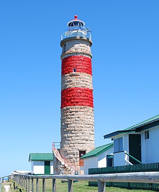
Dent Island Light is an active lighthouse on Dent Island, a small island off the coast of Queensland, Australia, part of the Whitsunday Group of the Whitsunday Islands. Located on the southwest tip of the island, the light guides ships navigating the Whitsunday Passage, between Whitsunday Island and the islands to the west, and marks the Dent Island Passage.

The Abrolhos Archipelago are a group of 5 small islands with coral reefs off the southern coast of Bahia state in the northeast of Brazil, between 17º25’—18º09’ S and 38º33’—39º05’ W. Caravelas is the nearest town. Their name comes from the Portuguese: abrolho, a rock awash or submerged sandbank that is a danger to ships. There is a conspicuous shipwreck in the group, SS Rosalinda.
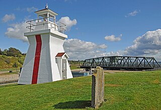
Balache Point Lighthouse also known as Balache Point Range Rear Lighthouse is an active Canadian lighthouse located next to the Canso Canal, near Port Hastings, Inverness County, Nova Scotia. The salt shaker style light, which sits on a small hillock on the Cape Breton side of the canal, is the second lighthouse to be built on the site.

Araranguá Lighthouse is an active lighthouse in Araranguá, Brazil on the Atlantic Ocean.
Albardão Lighthouse is an active lighthouse located on a sandy strip known as Praia do Cassino, in the municipality of Santa Vitória do Palmar, Brazil on the South Atlantic Ocean; the lighthouse is one of the southernmost Brazilian lights.

Barra Rio Grande Lighthouse is an active lighthouse located on a sandy strip between the Lagoa dos Patos and the South Atlantic Ocean in the municipality of São José do Norte, Brazil.
Chuí Lighthouse is an active lighthouse in Barra do Chuí, at the mouth of Chuí Stream, just 1 kilometre (0.62 mi) from the Uruguayan border; the lighthouse is the southernmost of all the Brazilian lights.
Ilha da Moela Lighthouse is an active lighthouse on the namesake island 1.84 kilometres (1.14 mi) from Ponta do Munduba at the entrance of Santos Bay, Brazil. Ilha da Moela Lighthouse is the oldest lighthouse on the State of São Paulo coast and the entire island is a Brazilian Navy base.
Ilha de Santana Lighthouse is an active lighthouse on the namesake island located at the east entrance of the Baía de São Marcos, Maranhão, Brazil

Ilha Rasa Lighthouse is an active lighthouse on the namesake island located 11 kilometres (6.8 mi) from Guanabara Bay, Rio de Janeiro, Brazil.

Murano Lighthouse is an active lighthouse located in the south east part of the island of Murano in the Venetian Lagoon on the Adriatic Sea.
Sombrero Lighthouse is a lighthouse that marks the Anegada Passage, which is the route from Europe into the Caribbean. The lighthouse is located near the centre of Sombrero island, and reaches a height of almost 51 metres (167 ft) above sea level.

The Lighthouse Point Light is an active lighthouse in Beaver Harbour, New Brunswick on Drews Head, as it was known, on the western side of the bay.

The Sines Lighthouse is located at Cabo de Sines, in Sines, in the Setúbal District of Portugal. It is a 22-metre high white cylindrical tower with a red beacon.
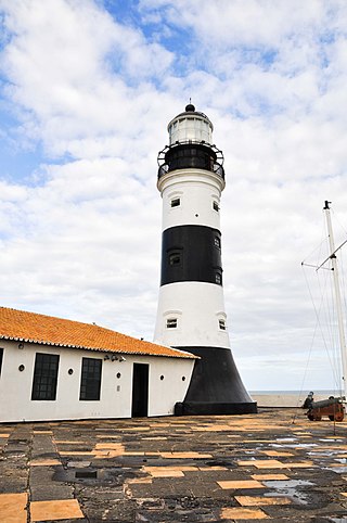
The Barra Lighthouse also known as the Santo Antônio Lighthouse, is a lighthouse in Salvador, Bahia, Brazil. It is located at the tip of the Padrão, now the Point of Santo Antônio, to the extreme south of Salvador, at the entrance of the Bay of All Saints. The lighthouse was built at the center of the Santo Antônio da Barra Fort.

