
Guanacaste is a province of Costa Rica located in the northwestern region of the country, along the coast of the Pacific Ocean. It is bordered by Nicaragua to the north, Alajuela Province to the east, and Puntarenas Province to the southeast. It is the most sparsely populated of all the provinces of Costa Rica. The province covers an area of 10,141 square kilometres (3,915 sq mi) and as of 2010, had a population of 354,154, with annual revenue of $2 billion.
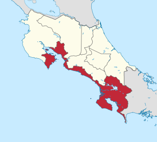
Puntarenas is a province of Costa Rica. It is located in the western part of the country, covering most of Costa Rica's Pacific Ocean coast, and it is the largest province in Costa Rica. Clockwise from the northwest it borders on the provinces Guanacaste, Alajuela, San José and Limón, and the neighbouring country of Panama.

The Cabo Blanco Absolute Natural Reserve is a Nature Reserve of Costa Rica, part of the Tempisque Conservation Area in the province of Puntarenas, covering an area of 3,140 acres (12.7 km2) terrestrial and 4,420 acres (17.9 km2) marine on the southern tip of the Nicoya Peninsula near Montezuma-Cabuya and Mal Pais.

Golfito is a district and port town of the Golfito canton, in the Puntarenas province of Costa Rica, located on the southern Pacific Coast, near the border of Panama.

Puntarenas is a city in the Puntarenas Province, on the Pacific coast of Costa Rica. As the seat of the Municipality of Puntarenas canton, it is awarded the title of city, which comprises the Puntarenas, Chacarita and El Roble districts. As the city of the first canton of the province, it is the capital city of the Puntarenas Province as well, according to the Administrative divisions of Costa Rica.

Montezuma is a town in Puntarenas Province, Costa Rica which began as a remote fishing village and has gained popularity since the 1980s among tourists on a budget.

Corcovado National Park is a National Park on the Osa Peninsula, in Osa Canton, located on the southwestern regions of Costa Rica, which is a part of the Osa Conservation Area. Corcovado National Park was established on October 24, 1975 and occupies an area of 424 square kilometres (164 sq mi). It is currently the largest park in Costa Rica and extends over about a third of the Osa Peninsula.

Manuel Antonio National Park is a small national park in the Central Pacific Conservation Area located on the Pacific coast of Costa Rica, just south of the city of Quepos, Puntarenas, and 157 km (98 mi) from the national capital of San José. It was established in 1972, when the local community sought conservation to prohibit development and destruction of the natural environment. They also protested the beach restrictions on locals by foreign owners. The park has a land area of 1,983 ha and 25,634 ha of water area for a total of 27,587 ha. Despite being one of the smaller Costa Rican parks in land area, Manuel Antonio is the most popular of the 30 national parks in Costa Rica, visited by 4,388,460 people from 2012 to 2022.

Caño Island is a small island and biological reserve in the Bahia de Corcovado in Osa, Costa Rica. It is on the Pacific Ocean side of Costa Rica, 10 miles (16 km) west of Punta Llorona on Península de Osa. It rises steeply to a flat top of 123 metres (404 ft) in height.

Golfo Dulce is a gulf in Costa Rica, located at the south of the Province of Puntarenas. The inlet starts on the Pacific Ocean side of Costa Rica and extends slightly northward before turning west. The most westward part is at the city of Rincon. The bay separates the Osa Peninsula from the mainland Costa Rica.

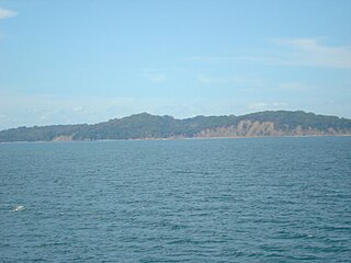
The Nicoya Peninsula is a peninsula on the Pacific coast of Costa Rica. It is divided into two provinces: Guanacaste Province in the north, and the Puntarenas Province in the south. It is located at 10°N 85.4166667°W. It varies from 19 to 37 miles (60 km) wide and is approximately 75 miles (121 km) long, forming the largest peninsula in the country. It is known for its beaches and is a popular tourist destination.

The Osa Peninsula is a peninsula located in southwestern Costa Rica, in the Puntarenas Province, with the Pacific Ocean to the west and the Golfo Dulce to the east. The peninsula was formed geologically by a faulting system that extends north into California.

Puerto Jiménez is the thirteenth canton of the Puntarenas province of Costa Rica. It is located in the Osa Peninsula next to the Golfo Dulce and the Pacific Ocean, it is the main gateway to the Corcovado National Park.
Osa is a canton in the Puntarenas province of Costa Rica. The head city is in Puerto Cortés district.

Tourism in Costa Rica has been one of the fastest growing economic sectors of the country and by 1995 became the largest foreign exchange earner. Since 1999, tourism has earned more foreign exchange than bananas, pineapples and coffee exports combined. The tourism boom began in 1987, with the number of visitors up from 329,000 in 1988, through 1.03 million in 1999, over 2 million in 2008, to a historical record of 2.66 million foreign visitors in 2015. In 2012, tourism contributed with 12.5% of the country's GDP and it was responsible for 11.7% of direct and indirect employment. In 2009, tourism attracted 17% of foreign direct investment inflows, and 13% in average between 2000 and 2009. In 2010, the tourism industry was responsible for 21.2% of foreign exchange generated by all exports. According to a 2007 report by ECLAC, tourism contributed to a reduction in poverty of 3% in the country.
San Lucas Island National Park is an island located off the Pacific shore of Costa Rica in the Gulf of Nicoya. It is part of the Puntarenas district in the canton and province of the same name.

Cabuya is a small fishing village on the Nicoya Peninsula of Costa Rica.
Lepanto is a district of the Puntarenas canton, in the Puntarenas province of Costa Rica.
Paquera is a district of the Puntarenas canton, in the Puntarenas province of Costa Rica.
Savegre is a district of the Quepos canton, in the Puntarenas province of Costa Rica.
