
Três Corações is a municipality in the south of Minas Gerais state in Brazil. As of 2020, the city population was estimated at 80,032, making it one of the largest cities in the south of Minas Gerais. The city is geographically located close to the circumcenter of the three largest metropolitan areas in Brazil, thus making it a strategic hub for commerce. The city is internationally famous for being the birthplace of football legend Pelé.

Almenara, is a municipality in the northeast of the Brazilian state of Minas Gerais. Situated on the Jequitinhonha River it is the largest city in that river valley. Its 2020 population was estimated at 42,143 and the municipal area was 2,301 km².
São Vicente may refer to:
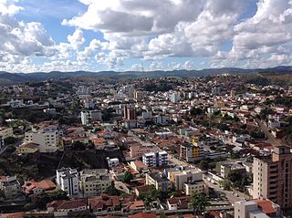
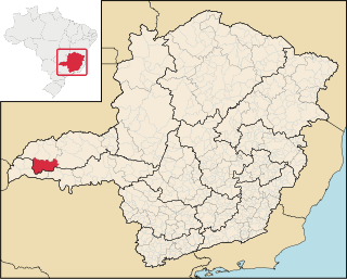
Teófilo Otoni is a municipality in northeast Minas Gerais state, Brazil. The population of the municipality was 140,937 in 2020 and the area is 3,242.818 km2.

The Mantiqueira Mountains are a mountain range in Southeastern Brazil, with parts in the states of São Paulo, Minas Gerais and Rio de Janeiro. It rises abruptly from the northwestern bank of the Paraíba do Sul River and extends northeastward for approximately 320 km (200 mi), reaching a height of 2,798 m (9,180 ft) at Pedra da Mina. The mountains, which eventually merge with the Serra do Espinhaço, were originally forest-covered, except for the peaks that rise above the tree line. They provide charcoal and pasture for cattle; on the lower slopes there are several health and tourist resorts, such as Campos do Jordão, Brazil's highest city. The name Mantiqueira derives from a Tupi word meaning "mountains that cry", denoting the large number of springs and streams found there.

Purian is a pair of extinct languages of eastern Brazil:
São Francisco may refer to:

Pai Pedro is a municipality in the northeast of the Brazilian state of Minas Gerais. As of 2020 the population was 6,094 in a total area of 785 km2 (303 sq mi). The elevation is 520 meters (1,710 ft). It became a municipality in 1997. The postal code (CEP) is 39517-000.
Campina Verde is a municipality in the north of the Brazilian state of Minas Gerais. As of 2020 the population was 19,752 in a total area of 3,663 km². It became a municipality in 1938.

São Francisco de Sales is a municipality in the west of the Brazilian state of Minas Gerais. As of 2020 the population was 6,274 in a total area of 1,129 km². It became a municipality in 1962.

União de Minas is a municipality in the west of the Brazilian state of Minas Gerais.

São Sebastião do Paraíso is a Brazilian municipality located in the southwest of the state of Minas Gerais. Its population as of 2020 was 71,445 people living in a total area of 822 km². The city belongs to the meso-region of Sul e Sudoeste de Minas and to the micro-region of São Sebastião do Paraíso. It became a municipality in 1870. The city and surrounding area are famous for the growing of high-quality coffee.

Cabo Verde is a Brazilian municipality located in the southwest of the state of Minas Gerais. Its population as of 2020 was 14,075 people living in a total area of 367 km². The city belongs to the meso-region of Sul e Sudoeste de Minas and to the micro-region of São Sebastião do Paraíso. It became a municipality in 1877. The municipality is an important producer of coffee.
Rio Verde Grande is a river of Minas Gerais state in eastern Brazil, that forms the boundary with Bahia state in its lowest reaches. It is a tributary of the São Francisco River.
The Do Peixe River is a river of Minas Gerais state in southeastern Brazil. It is a tributary of the Cabo Verde River.

The Kamakã languages are a small family of extinct Macro-Jê languages of Bahía, northeastern Brazil. The attested Kamakã languages are:
Cape Verde, in Portuguese Cabo Verde, is an island country in West Africa.
Jacob Philip Wingerter was a Christian evangelist and German presbyter living in Brazil.
