
The country of Brazil occupies roughly half of South America, bordering the Atlantic Ocean. Brazil covers a total area of 8,514,215 km2 (3,287,357 sq mi) which includes 8,456,510 km2 (3,265,080 sq mi) of land and 55,455 km2 (21,411 sq mi) of water. The highest point in Brazil is Pico da Neblina at 2,994 m (9,823 ft). Brazil is bordered by the countries of Argentina, Bolivia, Colombia, Guyana, Paraguay, Peru, Suriname, Uruguay, Venezuela, and French Guiana.

Amazonas is a state of Brazil, located in the North Region in the north-western corner of the country. It is the largest Brazilian state by area and the ninth-largest country subdivision in the world. It is the largest country subdivision in South America, being greater than the areas of Chile, Paraguay, and Uruguay combined. Neighbouring states are Roraima, Pará, Mato Grosso, Rondônia, and Acre. It also borders the nations of Peru, Colombia and Venezuela. This includes the Departments of Amazonas, Vaupés and Guainía in Colombia, as well as the Amazonas state in Venezuela, and the Loreto Region in Peru.

The Iguazu River, also called Rio Iguassu, is a river in Brazil and Argentina. It is an important tributary of the Paraná River. The Iguazu River is 1,320 kilometres (820 mi) long, with a drainage basin of 62,000 km2 (24,000 sq mi).

Manhuaçu is a municipality in Eastern Minas Gerais state, in Brazil. Its population was 91,169 (2020) and its area is 628 km2.
The Serra do Mar is a 1,500 km (930 mi) long system of mountain ranges and escarpments in Southeastern Brazil.

The Tietê River is a Brazilian river in the state of São Paulo.

The Jequitinhonha River flows mainly through the Brazilian state of Minas Gerais. Its source lies near Diamantina in the Espinhaço Mountains at an elevation of 1,200 metres (3,900 ft), after which it flows northward and then east-northeastward across the uplands. At Salto da Divisa, it is interrupted by the Cachoeira (falls) do Salto Grande, 43 metres (141 ft) high. The river descends to the coastal plain at the city of Jequitinhonha, beyond which it is also called Rio Grande do Belmonte, and empties into the Atlantic Ocean at Belmonte in Bahia state after a course of approximately 1,090 kilometres (680 mi). The main tributaries are the Araçuaí River, Piauí, São Miguel, Itacambiruçu, Salinas, São Pedro, and São Francisco.

The Paranapanema River is one of the most important rivers of the interior of the Brazilian state of São Paulo. The river forms most of the boundary between the states of São Paulo and Paraná.

The Paranaíba River is a Brazilian river whose source lies in the state of Minas Gerais in the Mata da Corda mountains, municipality of Rio Paranaíba, at an altitude of 1,148 meters; on the other face of this mountain chain are the sources of the Abaeté river, tributary of the São Francisco River. The length of the river is approximately 1,000 kilometres (620 mi) up to the junction with the Grande River, both of which then form the Paraná River, at the point that marks the borders of the states of São Paulo, Minas Gerais, and Mato Grosso do Sul.

Muriaé is a municipality in southeast Minas Gerais state, Brazil. It is located in the Zona da Mata region and its population in 2022 (IBGE) was approximately 104,108 inhabitants.

Salto Grande is a municipality in the state of São Paulo in Brazil. The population in 2020 is 9,364 and the area is 189.072 km2. The elevation is 436 m (1,430 ft).

The coastline of Brazil measures 7,491 km, making it the 16th longest national coastline in the world. The coastline touches exclusively the Atlantic Ocean. Brazil's coastline has many geographical features such as islands, reefs, bays, and its 2,095 beaches.

The Ribeira de Iguape River, or simply the Ribeira River, is a river of Paraná and São Paulo states in southeastern Brazil. It flows into the Atlantic Ocean near Iguape. The river is home to several endemic species of fish. So far no dams have been built on the river, although four have been proposed. Although it flows through a relatively sparsely populated region with untouched areas of Atlantic Forest, the river has been contaminated with heavy metals from mining beyond the point where it is considered safe to eat the molluscs found in the river and its estuary.
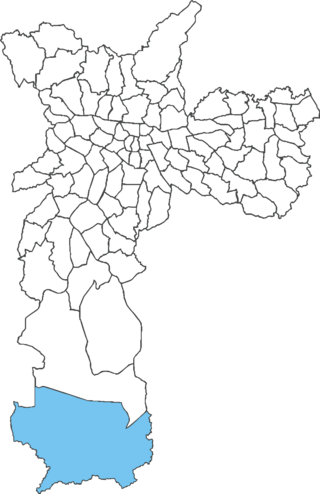
Marsilac is one of 96 districts of São Paulo, Brazil, located in the extreme south tip of the city in the subprefecture of Parelheiros. Its name is a tribute to engineer Jose Alfredo Marsilac, who developed many techniques for building roads and tunnels, even after losing 99% of his vision from being hit by a bomb in the Revolution of 1932.

The Tietê Bus Terminal is the largest bus terminal in Latin America, and the second largest in the world, after the Port Authority Bus Terminal in New York City. The terminal is located in the Santana district in the city of São Paulo, Brazil. The official name in Portuguese is Terminal Rodoviário Governador Carvalho Pinto, named after Carlos Alberto Alves de Carvalho Pinto, a former Governor of the State of São Paulo.
Enedina Alves Marques was a Brazilian engineer and teacher who worked for the Paraná State's Department of Water and Energy. Upon graduating from the Federal University of Paraná in 1945 with a degree in civil engineering, she became the first black woman to receive an engineering degree in Brazil and the first woman to receive an engineering degree in Paraná State.

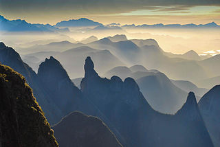
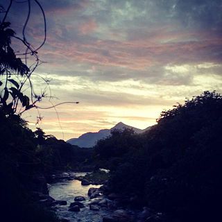
The Três Picos State Park is a state park in the state of Rio de Janeiro, Brazil. It preserves a large, mountainous region of Atlantic Forest.
The Bacia do Rio Macacu Environmental Protection Area is an environmental protection area in the state of Rio de Janeiro, Brazil.

The Pico do Marumbi State Park is a State park in the state of Paraná, Brazil.
