Lake Mead National Recreation Area is a U.S. national recreation area in Southeastern Nevada and Northwestern Arizona. Operated by the National Park Service, Lake Mead NRA follows the Colorado River corridor from the westernmost boundary of Grand Canyon National Park to just north of the cities of Laughlin, Nevada and Bullhead City, Arizona. It includes all of the eponymous Lake Mead as well as the smaller Lake Mohave – reservoirs on the river created by Hoover Dam and Davis Dam, respectively – and the surrounding desert terrain and wilderness.

The Dead Mountains are a mountain range in the southeastern Mojave Desert, in San Bernardino County, California. The range borders the tri-state intersection of Nevada, Arizona and California, and the Mohave Valley, with the Fort Mojave Indian Reservation bordering the range foothills on the east and northeast, in the three states.

The Mt. Moriah Wilderness is a 89,790-acre (36,340 ha) wilderness area in the northern part of the Snake Range of White Pine County, in the eastern section of the state of Nevada in the western United States.
The Table Mountain Wilderness is a protected wilderness area in the Monitor Range of Nye County in the central section of the state of Nevada. It is the third largest wilderness area in the state. The nearest city is Tonopah, Nevada. The Table Mountain Wilderness Area covers 92,600 acres (37,500 ha), and is administered by the Humboldt-Toiyabe National Forest. The 1860s ghost town of Belmont is nearby.

La Madre Mountain Wilderness Area consists of 47,180 acres (19,090 ha) covering a part of Clark County, Nevada, that lies just west of the city of Las Vegas, between that city and Mount Charleston. The area includes La Madre Mountain and several archaeological areas including the Brownstone Canyon Archaeological District. The area is administered by the Humboldt-Toiyabe National Forest and the Bureau of Land Management.

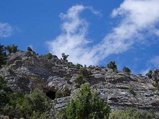
Brownstone Canyon Archaeological District comprises 2,920 acres (1,180 ha) and is located in the La Madre Mountain Wilderness Area which covers 47,180 acres (19,090 ha) in southern Nevada. The area is administered by the Humboldt-Toiyabe National Forest and the Bureau of Land Management and includes many petroglyphs.

The Black Rock Desert Wilderness is a U S Wilderness Area in Nevada under the Bureau of Land Management. It is located in the east arm of the Black Rock Desert playa east of the Black Rock Range and west of the Jackson Mountains. The wilderness has a land area of 314,829 acres, or 1,274.1 km2. It is the largest U.S. designated wilderness area that is managed solely by the Bureau of Land Management, and the largest that is not located within a National Forest, National Park, or National Wildlife Refuge. It is located within the Black Rock Desert – High Rock Canyon Emigrant Trails National Conservation Area, also managed by the BLM.
Mount Grafton Wilderness is a 78,754-acre (31,871 ha) wilderness area in southern White Pine County and northern Lincoln County, in the U.S. state of Nevada. The Wilderness lies approximately 30 miles (48 km) south of the town of Ely and is administered by the U.S. Bureau of Land Management.

Fortification Range Wilderness is a 30,656-acre (12,406 ha) wilderness area in Lincoln County, in the U.S. state of Nevada. The Wilderness lies approximately 50 miles (80 km) southeast of the town of Ely and is administered by the U.S. Bureau of Land Management.

Weepah Spring Wilderness is a 51,480-acre (20,830 ha) wilderness area in Lincoln and Nye Counties, in the U.S. state of Nevada. The Wilderness lies approximately 35 miles (56 km) north of the town of Alamo and is administered by the U.S. Bureau of Land Management.
Becky Peak Wilderness is a 18,119-acre (7,332 ha) wilderness area in White Pine County, in the U.S. state of Nevada. Located north of the town of Mcgill, the Wilderness was created by the White Pine County Conservation, Recreation and Development Act of 2006 and is administered by the U.S. Bureau of Land Management.
Goshute Canyon Wilderness is a 42,544-acre (17,217 ha) wilderness area in northern White Pine County in the U.S. state of Nevada. Located in the Cherry Creek Range north of the town of Mcgill, the Wilderness was created by the "White Pine County Conservation, Recreation and Development Act of 2006" and is administered by the U.S. Bureau of Land Management.
Highland Ridge Wilderness is a 68,627-acre (27,772 ha) wilderness area in the southern part of the Snake Range of White Pine County, just south of Great Basin National Park, in the U.S. state of Nevada. Located approximately 20 miles (32 km) south of the town of Baker, the Wilderness was designated in 2006 and is administered by the U.S. Bureau of Land Management.

Bright Star Wilderness is a 8,190-acre (3,314 ha) wilderness area in Kern County in the U.S. state of California.
The Sylvania Mountains Wilderness is a federally designated wilderness area located 30 miles (48 km) east of Bishop in the state of California. The wilderness is 18,677acres in size and is managed by the Bureau of Land Management (BLM). The California Desert Protection Act of 1994 created the Sylvania Mountains Wilderness and was added to the National Wilderness Preservation System. The wilderness is bordered by Nevada stateline on the east, Piper Mountain Wilderness on the west and Death Valley National Park to the south.
The Augusta Mountains are a small mountain range in Pershing, Churchill and Lander counties of Nevada.

The Omnibus Public Land Management Act of 2009 is a land management law passed in the 111th United States Congress and signed into law by President Barack Obama on March 30, 2009. The bill designates millions of acres in the US as protected and establishes a National Landscape Conservation System. It includes funding for programs, studies and other activities by the Department of the Interior and the Department of Agriculture, and in some cases bars further geothermal leasing, oil and gas leasing, and new mining patents on certain stretches of protected land.
The Stateline Wilderness is a wilderness area located in San Bernardino County, California, approximately three miles northwest of Primm, Nevada and I-15. Having an area of approximately 7,004 acres (2,834 ha), it contains the eastern terminus of the 15-mile-long (24 km) Clark Mountain Range.
The Black Canyon Wilderness in the state of Nevada is a 17,220-acre (6,970 ha) wilderness area located in the Dry Lake Watershed along Dry Lake Valley at Black Canyon of the Colorado, west of the Great Basin Divide. It is part of the Lake Mead National Recreation Area. Immediately to the south is the Eldorado Wilderness, in the El Dorado Mountains. Together, the two wilderness areas protect 49,170 acres (19,900 ha).

Ireteba Peaks Wilderness is a 32,745 acre wilderness area spanning the area of the southern part of Eldorado Mountains to the northern parts of Lake Mohave. It is located 45 miles (72 km) south of Las Vegas and was designated as a wilderness area in 2002. Iretaba Peaks Wilderness is managed by the National Park Service and the Bureau of Land Management. The western (BLM) portion of the wilderness is part of Avi Kwa Ame National Monument, designated in 2023.
