Cairngorm Lochs

Last updated
Cairngorm Lochs
Loch Avon - geograph.org.uk - 886066.jpg
A view towards the east end of Loch Avon
Location Grampian and Highland, Scotland
Coordinates 57°6′12.36″N3°37′37.68″W / 57.1034333°N 3.6271333°W / 57.1034333; -3.6271333 Coordinates: 57°6′12.36″N3°37′37.68″W / 57.1034333°N 3.6271333°W / 57.1034333; -3.6271333
Area1.73 km2 (0.67 sq mi) [1]
Established1981

Cairngorm Lochs is a protected wetland area in the Cairngorms, in the Grampian and Highland regions of Scotland. With a total area of 173 hectares, it covers five freshwater lochs which are among the highest areas of standing water in the UK. It has been protected as a Ramsar Site since 1981. [1]

Cairngorms mountain range in the eastern Highlands of Scotland

The Cairngorms are a mountain range in the eastern Highlands of Scotland closely associated with the mountain of the Cairn Gorm. The Cairngorms became part of Scotland's second national park on 1 September 2003. Although the Cairngorms give their name to, and are at the heart of, the Cairngorms National Park, they only form one part of the national park, alongside other hill ranges such as the Angus Glens and the Monadhliath, and lower areas like Strathspey.

Grampian former local government region of Scotland

Grampian was a local government region of Scotland from 1975 to 1996. It is now divided into the unitary council areas of:

Highland (council area) Council area of Scotland

Highland is a council area in the Scottish Highlands and is the largest local government area in the United Kingdom. It was the 7th most populous council area in Scotland at the 2011 census. It shares borders with the council areas of Aberdeenshire, Argyll and Bute, Moray and Perth and Kinross. Their councils, and those of Angus and Stirling, also have areas of the Scottish Highlands within their administrative boundaries.

The site is composed of five separate lochs: Etchachan, Uiane, Coire an Lochain, Avon and Einich. All five lakes are extremely oligotrophic and support highly specialized populations of zooplankton and phytoplankton; the two largest also support plant populations including Littorella uniflora, Lobelia dortmanna and Juncus bulbosus. [2]

Loch Etchachan lake in the United Kingdom

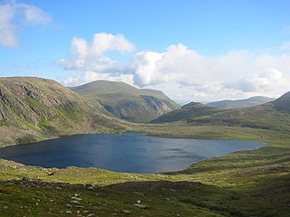
Loch Etchachan is an exceedingly remote freshwater loch set deep within the central Cairngorms plateau, in the Cairngorms National Park, located in the eastern Highlands of Scotland. It is the highest waterbody of its size in the UK, the surface being 927 metres (3,041 ft) above sea level.

Zooplankton Heterotrophic protistan or metazoan members of the plankton ecosystem

Zooplankton are heterotrophic plankton. Plankton are organisms drifting in oceans, seas, and bodies of fresh water. The word zooplankton is derived from the Greek zoon (ζῴον), meaning "animal", and planktos (πλαγκτός), meaning "wanderer" or "drifter". Individual zooplankton are usually microscopic, but some are larger and visible to the naked eye.

Phytoplankton Autotrophic members of the plankton ecosystem

Phytoplankton are the autotrophic (self-feeding) components of the plankton community and a key part of oceans, seas and freshwater basin ecosystems. The name comes from the Greek words φυτόν (phyton), meaning "plant", and πλαγκτός (planktos), meaning "wanderer" or "drifter". Most phytoplankton are too small to be individually seen with the unaided eye. However, when present in high enough numbers, some varieties may be noticeable as colored patches on the water surface due to the presence of chlorophyll within their cells and accessory pigments in some species.

As well as being recognised as a wetland of international importance under the Ramsar Convention, the lochs are additionally protected as they all lie within the boundaries of the Cairngorms National Park.

Ramsar Convention international treaty for the conservation and sustainable utilization of wetlands

The Ramsar Convention on Wetlands of International Importance especially as Waterfowl Habitat is an international treaty for the conservation and sustainable use of wetlands. It is also known as the Convention on Wetlands. It is named after the city of Ramsar in Iran, where the Convention was signed in 1971.

Cairngorms National Park national park

Cairngorms National Park is a national park in north east Scotland, established in 2003. It was the second of two national parks established by the Scottish Parliament, after Loch Lomond and The Trossachs National Park, set up in 2002. The park covers the Cairngorms range of mountains, and surrounding hills. Already the largest national park in the British Isles, in 2010 it expanded into Perth and Kinross.

Related Research Articles

Transboundary protected area protected area that spans boundaries of more than one country or sub-national entity, where the political border sections that are enclosed within its area are abolished

A transboundary protected area (TBPA) is an ecological protected area that spans boundaries of more than one country or sub-national entity. Such areas are also known as transfrontier conservation areas (TFCAs) or peace parks.

A Ramsar site is a wetland site designated to be of international importance under the Ramsar Convention.

Lough Foyle estuary

Lough Foyle, sometimes Loch Foyle, is the estuary of the River Foyle, on the north coast of Ireland. It lies between County Londonderry in Northern Ireland and County Donegal in the Republic of Ireland. Sovereignty over these waters has been in dispute since the Partition of Ireland.

Larne Lough lake in the United Kingdom

Larne Lough is a sea lough or inlet in County Antrim, Northern Ireland. The lough lies between Islandmagee and the mainland. At its mouth is the town of Larne. It is designated as an area of special scientific interest, a special protection area, and a Ramsar site to protect the wetland environment, particularly due to the presence of certain bird species and shellfish.

Gladhouse Reservoir lake in the United Kingdom

Gladhouse Reservoir, formerly Moorfoot Loch, is a reservoir in Midlothian, Scotland, five miles (8 km) south of Penicuik. It is the largest area of freshwater in the Lothians.

The Port Phillip Bay and Bellarine Peninsula Ramsar Site is one of the Australian sites listed under the Ramsar Convention as a wetland of international importance. It was designated on 15 December 1982, and is listed as Ramsar Site No.266. Much of the site is also part of either the Swan Bay and Port Phillip Bay Islands Important Bird Area or the Werribee and Avalon Important Bird Area, identified as such by BirdLife International because of their importance for wetland and waterbirds as well as for orange-bellied parrots. It comprises some six disjunct, largely coastal, areas of land, totalling 229 km2, along the western shore of Port Phillip and on the Bellarine Peninsula, in the state of Victoria. Wetland types protected include shallow marine waters, estuaries, freshwater lakes, seasonal swamps, intertidal mudflats and seagrass beds.

Edithvale-Seaford Wetlands nature reserve in Australia

The Edithvale-Seaford Wetlands are a group of two principally freshwater swamps, totalling 261 hectares, lying in the suburbs of Aspendale, Edithvale, Chelsea Heights, and Seaford in south-eastern Melbourne, Victoria, Australia. Together they form the Edithvale-Seaford Wetlands Ramsar Site. With the nearby Eastern Treatment Plant, they form the Carrum Wetlands Important Bird Area.

The Forrestdale and Thomsons Lakes Ramsar Site comprises two separate nature reserves, totaling 754 ha in area, protecting two shallow fresh to brackish, seasonal lakes in a suburban and agricultural landscape in south-western Western Australia. It is used mainly for birdwatching and walking. It lies in the Swan Coastal Plain bioregion. The site is recognised as being of international importance under the Ramsar Convention on Wetlands, under which it was designated Ramsar Site 481 on 7 June 1990.

Coongie Lakes lake

The Coongie Lakes is a freshwater wetland system located in the Far North region of South Australia. The 21,790-square-kilometre (8,410 sq mi) lakes system is located approximately 1,046 kilometres north of the Adelaide city centre. The wetlands includes lakes, channels, billabongs, shallow floodplains, deltas, and interdune swamps. It lies on the floodplain of Cooper Creek, an ephemeral river flowing through a desert landscape in the Lake Eyre Basin which rarely, after occasional large floods, empties into Lake Eyre. The wetland system has been recognised both as being of international importance by designation under the Ramsar Convention with a listing on 15 June 1987 and being nationally important within Australia with a listing in A Directory of Important Wetlands in Australia (DIWA). Its extent includes the regional town of Innamincka, the Malkumba-Coongie Lakes National Park, the Innamincka Regional Reserve, the Strzelecki Regional Reserve and the Coongie Lakes Important Bird Area.

Salinas of the English Port

Salinas of the English Port is a saline wetland in the southwestern part of the island of Maio, Cape Verde, northwest of the city Porto Inglês. It is a 5.34 km2 (2.06 sq mi) protected area and a Ramsar site. It encompasses ecological, landscape, historical and cultural values. The site is frequented by species of birds of conservation interest, some of them protected by national laws and international conventions, and some endemic to the archipelago.

Bridgend Flats is an area of mudflats and saltmarsh near the village of Bridgend on the island of Islay off the west coast of Scotland. Covering an area of 331 hectares, it is situated around the outflow of the River Sorn into Loch Indaal.

Castle Loch Lake in southern Scotland

Castle Loch is a shallow eutrophic loch covering an area of around 100 hectares in the town of Lochmaben in Dumfries and Galloway, Scotland. It lies to the west of Mochrum Loch and has 2 islets. The ruined Lochmaben Castle lies at the southern end of the loch.

Caithness Lochs Series of lochs in northern Scotland

Caithness Lochs is a protected wetland area in the historic county of Caithness in the far north of Scotland. With a total area of 1,379 hectares, it covers six freshwater lochs and a complex area of fen and swamp, and has been protected as a Ramsar Site since 1998.

The Kintyre Goose Roosts are a group of five oligotrophic hill lochs on the Kintyre peninsula in Argyll and Bute, western Scotland. With a total area of 312 hectares, they have been protected as a Ramsar Site since 1998.

The East Sanday Coast is a protected wetland area on and around the island of Sanday, the third-largest of the Orkney islands off the north coast of Scotland. With a total protected area of 1,515 hectares, the 55 kilometre stretch of coast includes rocky and sandy sections, sand dunes, machair habitats, intertidal flats, and saltmarsh. It has been protected as a Ramsar Site since 1997.

Greenlaw Moor is an area of raised heather moorland in the foothills of the Lammermuir Hills, in the Scottish Borders area of Scotland. Located north of the town of Greenlaw and with an area of 248 hectares, the moor has been protected as a Ramsar Site since 1996.

Fala Flow is an area of upland blanket bog on the edge of the Lammermuir Hills, in Midlothian, Scotland. Located north of the village of Fala, around 15km south east of Edinburgh, an area of 318 hectares has been designated as a Ramsar Site since 1990.

References

  1. 1 2 "Cairngorm Lochs". Ramsar Sites Information Service. Retrieved 27 February 2019.
  2. "UK Cairngorm Lochs 13002 RIS 2005" (PDF). Ramsar Sites Information Service. Retrieved 27 February 2019.