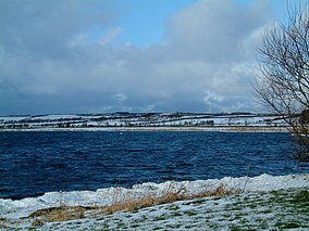
Loch Leven is a fresh water loch located immediately to the east of the burgh of Kinross in Perth and Kinross council area, central Scotland. Roughly triangular, the loch is about 6 km (3.7 mi) at its longest. Prior to the canalisation of the River Leven, and the partial draining of the loch in 1826-36, Loch Leven was considerably larger. The drop in water level by 1.4 m reduced to the loch to 75% of its former size, and exposed several small islands, as well as greatly increasing the size of the existing ones.

Loch Fleet is a sea loch on the east coast of Scotland, located between Golspie and Dornoch. It forms the estuary of the River Fleet, a small spate river that rises in the hills east of Lairg. The loch was designated a National Nature Reserve (NNR) in 1998, and is managed by a partnership between NatureScot, the Scottish Wildlife Trust (SWT) and Sutherland Estates. The NNR extends to 1058 hectares, including the Loch Fleet tidal basin, sand dunes, shingle ridges and the adjacent pine woods, including Balbair Wood and Ferry Wood. The tidal basin of the loch covers over 630 ha, and forms the largest habitat on the NNR.

Insh Marshes are an area of floodplain of the River Spey between Kingussie and Kincraig in Badenoch and Strathspey, Highland, Scotland. The marshes are said to be one of the most important wetlands in Europe. They lie at altitude of approximately 240 to 220 m above sea level, and form one of the largest areas of floodplain mire and fen vegetation in Scotland.
Muir of Dinnet is a national nature reserve (NNR) situated close to the village of Dinnet in Aberdeenshire, Scotland. The reserve extends 1166 hectares from the River Dee to Culbean hill, and encompasses a wide range of habitats including dry heath, raised bog, woodland, and two lochs: Loch Kinord and Loch Davan. Muir of Dinnet was first declared a NNR in 1977 due to its value as a habitat for flora and fauna, and its important geomorphological features, the most striking of which is the Burn O'Vat. Muir of Dinnet is owned by Dinnet Estate and managed by NatureScot, who provide a visitor centre and a range of other facilities including waymarked paths and a car park. As of 2012 it was estimated that approximately 40,000 people visited Muir of Dinnet each year.
Tentsmuir National Nature Reserve (NNR) is located southeast of Tayport in Fife, Scotland. The reserve is made up of three parts, encompassing Morton Lochs, Tentsmuir Point and Tayport Heath, and is managed by NatureScot. The different sections of Tentsmuir NNR were originally designated as separate national nature reserves at different times: The Morton Lochs section was designated in 1952; Tentsmuir, in 1954; and Tayport Heath, in 1988. While these discrete sections are distant from one another, they form part of the extensive dune system at Tentsmuir, and in 2003 SNH combined the three sites to become Tentsmuir National Nature Reserve. The adjoining Tentsmuir Forest is managed by Forestry and Land Scotland and covers most of the land between the three portions of the NNR.

Loch Lomond National Nature Reserve (NNR) encompasses 430 hectares of land at the southeastern part of Loch Lomond in the council areas of Stirling and West Dunbartonshire, in Scotland. It covers the islands of Inchcailloch, Clairinsh, Torrinch, Creinch and Aber Isle, alongside areas of woodland and wetlands to either side of the mouth of the Endrick Water. NatureScot owns two parts of the reserve - the island of Inchcailloch and part of Gartfairn Wood - and the rest is privately owned. The reserve is managed by a partnership consisting of NatureScot, the RSPB Scotland and the Loch Lomond and The Trossachs National Park, along with the owners and tenants of the land under agreements. Within this framework NatureScot directly manage the islands of Clairinsh, Inchcailloch, Torrinch and Creinch, and land to the north of the Endrick Water. The RSPB manages the area to the south of the Endrick Water, and the National Park manages visitor facilities on Inchcailloch.

The Caithness and Sutherland Peatlands is a large area of blanket bog and peatland, covering a number of disconnected regions across the historic counties of Caithness and Sutherland in the far north of Scotland, across an area known as the Flow Country. With a total area of 143,503 hectares, it is one of the largest recognised conservation sites in the UK, and is the largest Ramsar Site in Scotland.

The Kintyre Goose Roosts are a group of five oligotrophic hill lochs on the Kintyre peninsula in Argyll and Bute, western Scotland. With a total area of 312 hectares, they have been protected as a Ramsar Site since 1998.
Greenlaw Moor is an area of raised heather moorland in the foothills of the Lammermuir Hills, in the Scottish Borders area of Scotland. Located north of the town of Greenlaw and with an area of 248 hectares, the moor has been protected as a Ramsar Site since 1996.
Fala Flow is an area of upland blanket bog on the edge of the Lammermuir Hills, in Midlothian, Scotland. Located north of the village of Fala, around 15km south east of Edinburgh, an area of 318 hectares has been designated as a Ramsar Site since 1990.
Eilean na Muice Duibhe, also known as Duich Moss, is an area of low-level blanket mire on the island of Islay, off the west coast of Scotland. Located south of the town of Bowmore and with an area of 576 hectares, the area has been protected as a Ramsar Site since 1988.
Loch an Duin is a complex system of freshwater, brackish and sea lochs, tidal channels and islands, on and close to North Uist off the west coast of Scotland. An area of 2,621 hectares has been protected since 1990 as a Ramsar Site.

Loch Eye is a shallow freshwater loch, located close to the east coast of Scotland between the Moray Firth, Dornoch Firth and Cromarty Firth. Covering an area of 205 hectares, it is an important site for waterfowl and has been protected since 1986 as a Ramsar Site, a Special Protection Area and a Site of Special Scientific Interest.

Loch of Lintrathen is a man-made loch occupying a glacial basin at the southern end of Glen Isla, approximately 13 kilometres (8.1 mi) west of town of Kirriemuir in Angus, Scotland. The small village of Bridgend of Lintrathen lies on the southern shore of the loch, which is owned by Scottish Water and used as a water supply reservoir as well as an important wildlife site. The loch has been the main water supply for the city of Dundee and Angus since 1875. The water in the Loch of Lintrathen feeds down from Backwater Reservoir 4 kilometres (2.5 mi) to the north and exits it via sluices at Bridgend of Lintrathen, flowing southward past Lintrathen Mill in the ‘Melgam Water’, which has a confluence with the River Isla 3 kilometres (1.9 mi) farther south at Airlie Castle. The loch has a surface area of 151.1 hectares and its dam is an earthworks dam.

Loch of Kinnordy is a small loch located just west of town of Kirriemuir in Angus, Scotland, which is an important wildlife habitat. The loch itself is approximately 22 hectares, though this has varied over time with drainage attempts and the silting up of the outflow stream. Including surrounding fen, swamp and mire, 85 hectares are protected as a Ramsar Site.
Loch Spynie is a small loch located between the towns of Elgin and Lossiemouth in Moray, Scotland. Close to Spynie Palace, the ancient home of the bishops of Moray, it is an important wildlife habitat which is protected as a Ramsar Site.
The Moray and Nairn Coast is a protected wetland site on the southern shore of the Moray Firth, in the west of Scotland. A total of 2,412 hectares comprises two areas: intertidal flats, saltmarsh and sand dunes at Findhorn Bay and Culbin Bar, and alluvial deposits and woodland of the lower River Spey and Spey Bay. It has been protected as a Ramsar Site since 1997.

South Tayside Goose Roosts is a composite wetland site to the west of Perth in central Scotland, covering a total of 331 hectares, which has been protected as a Ramsar Site since 1993. Incorporating three disconnected sections, separated by several kilometres, the site contains seven freshwater lochs along with other wetland habitats, including one of the largest raised bogs in the region.

The North Uist Machair and Islands is a protected wetland area in the Outer Hebrides of Scotland. A total of 4,705 hectares comprises seven separate areas: four sites on the west and north coasts of North Uist, as well as the whole of the island of Boreray and parts of Berneray and Pabbay in the Sound of Harris. The site primarily contains machair areas, with a range of habitats including sand dunes, acid grassland and freshwater wetlands, including nutrient-rich marshes and fens, wet and dry machair and saltmarsh. It has been protected as a Ramsar Site since 1999.

The South Uist Machair and Lochs is a protected wetland area on the west coast of South Uist in the Outer Hebrides of Scotland. A total of 5,019 hectares contains blanket bog, oligotrophic lochs, wet and dry machair, fresh and saltwater marsh, coastal dunes and sandy and rocky shores. It includes the estuary waters of the Howmore River, as well as Loch Bi and Loch Druidibeg. It has been protected as a Ramsar Site since 1976.