Wrightwood is a census-designated place in San Bernardino County, California. It sits at an elevation of 5,935 feet (1,809 m). The population was 4,525 at the 2010 census, up from the population of 3,837 at the 2000 census. Wrightwood is located 77 miles northeast of Los Angeles.

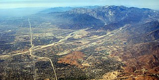
Cajon Pass is a mountain pass between the San Bernardino Mountains and the San Gabriel Mountains in Southern California. It was created by the movements of the San Andreas Fault. Located in the Mojave Desert, the pass is an important link from the Greater San Bernardino Area to the Victor Valley, and northeast to Las Vegas.

The Victor Valley is a valley in the Mojave Desert and subregion of the Inland Empire, in San Bernardino County in Southern California.
The Chemehuevi Indian Tribe of the Chemehuevi Reservation is a federally recognized tribe of Chemehuevi people, who are the southernmost branch of Southern Paiute people.
El Cerrito, Spanish for "the little hill," is a neighborhood of the Mid-City region of San Diego, California. El Cerrito is a residential neighborhood, consisting mostly of suburban homes, with some commercial activity along the streets that define its borders.
Rolando is a neighborhood of the Mid-City region of San Diego, California. Rolando is mostly residential with the exception of El Cajon Boulevard, which features the Campus Plaza shopping center. Rolando is divided by University Avenue into two sections: Rolando Village to the north, and Rolando Park to the south.

El Cajon Boulevard is a major east–west thoroughfare through San Diego, La Mesa and El Cajon, California. Before the creation of Interstate 8 it was the principal automobile route from San Diego to El Cajon, the Imperial Valley, and points east as U.S. Route 80; it is now signed as a business loop of Interstate 8.
Sadou is an unincorporated community in Lafayette Parish, Louisiana, United States.
Smętne is a village in the administrative district of Gmina Strzegowo, within Mława County, Masovian Voivodeship, in east-central Poland.

Wilkowo is a village in the administrative district of Gmina Koczała, within Człuchów County, Pomeranian Voivodeship, in northern Poland. It lies approximately 9 kilometres (6 mi) north-east of Koczała, 38 km (24 mi) north-west of Człuchów, and 108 km (67 mi) south-west of the regional capital Gdańsk.
Etta is an unincorporated community in Caroline County, in the U.S. state of Virginia.
Voto is a municipality in Cantabria, Spain.
Murdocksville is an unincorporated community in Allegheny County, in the U.S. state of Pennsylvania.
Crowder Canyon, originally Coyote Canyon, is a valley in San Bernardino County, California. Its mouth was at an elevation of 2,999 feet / 914 meters at its confluence with Cajon Canyon. Its source was at an elevation of 4200 feet at 34°21′02″N117°26′04″W near Cajon Summit. The canyon runs southward just west of the top of Cajon Pass then turns southwestward to meet Cajon Canyon.
Baldy Mesa is a summit whose tallest peaks on its southern extremity, overlook the upper Cajon Canyon in San Bernardino County, California. Its tallest point is an unnamed 4,964 foot high hill on the southwest end of the mesa overlooking the upper Cajon Canyon. The heights that lie along the ridge overlooking the canyon toward the east gradually descend in elevation from one approximately 4,770 feet to the 4,606 foot hill at its far southeastern end at 34°21′34″N117°28′39″W. The mesa descends gradually in elevation to the north, toward the distant Mohave River. it is bounded on the east by the Oro Grande Wash.
Cajon Junction is an unincorporated community in Cajon Canyon and the northern Cajon Pass area, within San Bernardino County, California.
Summit Valley is a valley along SR 138 in the San Bernardino Mountains, east of Cajon Pass within San Bernardino County, California.
Cajon Canyon, originally named El Cajon De San Gabriel De Amuscopiabit, El Cajon in Spanish meaning "the box" in English, is a long valley ending in a box canyon in the northeastern San Gabriel Mountains, within San Bernardino County, California.
Horsethief Canyon, is a canyon, the upper part of Summit Valley in San Bernardino County, California. Its mouth is at an elevation of 3,123 feet / 952 meters. Its head lies at 34°19′33″N117°25′38″W at an elevation of 3,800 feet just east of the summit of Cajon Pass.