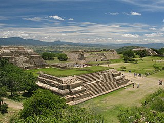
The city and municipality of Oaxaca de Juárez, or simply Oaxaca, is the capital and largest city of the Mexican state of the same name. It is located in the Centro District in the Central Valleys region of the state, on the foothills of the Sierra Madre at the base of the Cerro del Fortín extending to the banks of the Atoyac River. The city relies heavily on tourism, which is based on its large number of colonial-era structures as well as the native Zapotec and Mixtec cultures and archeological sites. It, together with the archeological site of Monte Albán, was named a World Heritage Site in 1987. It is also the home of the month-long cultural festival called the "Guelaguetza", which features Oaxacan dance from the seven regions, music and a beauty pageant for indigenous women.
San Pablo Guelatao is a town and the seat of the Municipality of Guelatao de Juárez, in the Mexican state of Oaxaca. It is part of the Ixtlán District in the Sierra Norte de Oaxaca region.

The Papaloapan River is one of the main rivers of the Mexican state of Veracruz. Its name comes from the Nahuatl papaloapan meaning "river of the butterflies".

The Peninsular Ranges are a group of mountain ranges that stretch 1,500 km (930 mi) from Southern California to the southern tip of the Baja California Peninsula; they are part of the North American Coast Ranges, which run along the Pacific Coast from Alaska to Mexico. Elevations range from 500 to 10,834 feet.
Sequoia National Forest is located in the southern Sierra Nevada mountains of California. The U.S. National Forest is named for the majestic Giant Sequoia trees which populate 38 distinct groves within the boundaries of the forest.

Totontepec Villa de Morelos is a small village and municipality, in the Sierra Mixe district of the Mexican state of Oaxaca. It is located some 1840 metres above sea level and some 326 km from the state capital, Oaxaca de Juárez. In spite of the Mixe influence, the toponym is Nahuatl in origin, meaning "hot hill".

Amatique Bay is a large bay in the Gulf of Honduras, along the eastern coast of Guatemala and Belize. It stretches from Santo Tomás de Castilla in the south to Punta Gorda in the north, where it opens to the Caribbean Sea. Its south-eastern limits are marked by a small peninsula known as Punta de Manabique where a $27 million gas terminal is planned

The Sierra Madre de Oaxaca pine-oak forests is an ecoregion of the Tropical and subtropical coniferous forests biome, in Southern Mexico.

The Sierra Madre de Oaxaca is a mountain range in southern Mexico. It is primarily in the state of Oaxaca, and extends north into the states of Puebla and Veracruz.

Ixtlán de Juárez is a town and municipality in the Mexican state of Oaxaca about 65 km north of the city of Oaxaca on Federal Highway 175 towards Veracruz. It is part of the Ixtlán District in the Sierra Norte de Oaxaca region.
San Juan Bautista Valle Nacional is a town and municipality in Oaxaca in south-western Mexico. The municipality covers an area of 394.23 km² within the Sierra Juárez mountains. It is part of the Tuxtepec District of the Papaloapan Region. The town lies on the north bank of the Valle Nacional River, a tributary of the Papaloapan River.
The Valle Nacional River is a river of Oaxaca state in Mexico. The river originates in the Sierra Juárez, Oaxaca. The ecology of the region, originally one of pine forests, is threatened by logging, agriculture and grazing. The Valle Nacional flows past San Juan Bautista Valle Nacional, and joins the Santo Domingo River to the southwest of San Juan Bautista Tuxtepec to form the Papaloapan River.

The Universidad de la Sierra Juárez(UNSIJ) is a university located in the town of Ixtlán de Juárez in the Mexican state of Oaxaca. It is part of the State University System of Oaxaca (SUNEO) and is public institution of higher education and scientific research. The university is funded by the Oaxaca State Government and the Mexican Federal Government.

Mucuchíes is a town in the Rangel Municipality of Mérida State, Venezuela. It is at an altitude of 2,983 meters and has a cool climate, with an average temperature of 11°C. Patron saint festivities are held during the month of December, with their patron saints St. Lucia and St. Benedict the Moor. The town was founded by Bartolomé Gil Naranjo in 1586.

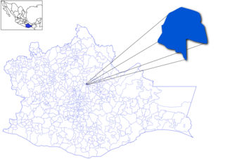
Ixtlán District is located in the northeast of the Sierra Norte region of the State of Oaxaca, Mexico.
The Benito Juárez National Park is in the Valles Centrales Region of Oaxaca, Mexico, and includes parts of the municipalities of San Felipe Tejalapam and San Andres Huayapan. The southern boundary of the park is about 5 kilometers north of the City of Oaxaca. The park was established in 1937 during the presidency of General Lazaro Cardenas del Rio, and is named after President Benito Juárez, who was a native of Oaxaca.
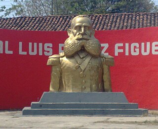
Luis Pérez Figueroa was a Mexican general who fought in the war of independence that followed the French intervention in Mexico.

