The Mississippi River is the second-longest river and chief river of the second-largest drainage system on the North American continent, second only to the Hudson Bay drainage system. From its traditional source of Lake Itasca in northern Minnesota, it flows generally south for 2,320 miles (3,730 km) to the Mississippi River Delta in the Gulf of Mexico. With its many tributaries, the Mississippi's watershed drains all or parts of 32 U.S. states and two Canadian provinces between the Rocky and Appalachian mountains. The main stem is entirely within the United States; the total drainage basin is 1,151,000 sq mi (2,980,000 km2), of which only about one percent is in Canada. The Mississippi ranks as the fifteenth-largest river by discharge in the world. The river either borders or passes through the states of Minnesota, Wisconsin, Iowa, Illinois, Missouri, Kentucky, Tennessee, Arkansas, Mississippi, and Louisiana.

The Rio Grande is one of the principal rivers in the southwestern United States and northern Mexico. The Rio Grande begins in south-central Colorado in the United States and flows to the Gulf of Mexico. After passing through the length of New Mexico along the way, it forms part of the Mexico–United States border. According to the International Boundary and Water Commission, its total length was 1,896 miles (3,051 km) in the late 1980s, though course shifts occasionally result in length changes. Depending on how it is measured, the Rio Grande is either the fourth- or fifth-longest river system in North America.

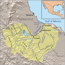
Veracruz, formally Veracruz de Ignacio de la Llave, officially the Free and Sovereign State of Veracruz de Ignacio de la Llave, is one of the 32 states that comprise the Federal Entities of Mexico. It is divided in 212 municipalities, and its capital city is Xalapa-Enríquez.

Francisco Vázquez de Coronado y Luján was a Spanish conquistador and explorer who led a large expedition from what is now Mexico to present-day Kansas through parts of the southwestern United States between 1540 and 1542. Vázquez de Coronado had hoped to reach the Cities of Cíbola, often referred to now as the mythical Seven Cities of Gold, which is a term not invented until American gold-rush days in the 1800s. His expedition marked the first European sightings of the Grand Canyon and the Colorado River, among other landmarks. His name is often Anglicized as "Vasquez de Coronado" or just Coronado.
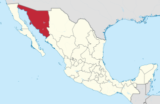
Sonora, officially Free and Sovereign State of Sonora, is one of 32 states which comprise the Federal Entities of Mexico. It is divided into 72 municipalities; the capital city is Hermosillo. Sonora is bordered by the states of Chihuahua to the east, Baja California to the northwest and Sinaloa to the south. To the north, it shares the U.S.–Mexico border primarily with the state of Arizona with a small length with New Mexico, and on the west has a significant share of the coastline of the Gulf of California.

Coahuila, formally Coahuila de Zaragoza, officially the Free and Sovereign State of Coahuila de Zaragoza, is one of the 32 states of Mexico.

Juan de Oñate y Salazar was a Spanish conquistador from New Spain, explorer, and colonial governor of the province of Santa Fe de Nuevo México in the viceroyalty of New Spain. He led early Spanish expeditions to the Great Plains and Lower Colorado River Valley, encountering numerous indigenous tribes in their homelands there. Oñate founded settlements in the province, now in the Southwestern United States.
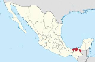
Tabasco, officially the Free and Sovereign State of Tabasco, is one of the 32 Federal Entities of Mexico. It is divided into 17 municipalities and its capital city is Villahermosa.

Michoacán, formally Michoacán de Ocampo, officially the Free and Sovereign State of Michoacán de Ocampo, is one of the 32 states which comprise the Federal Entities of Mexico. The state is divided into 113 municipalities and its capital city is Morelia. The city was named after José María Morelos, a native of the city and one of the main heroes of the Mexican War of Independence.

Guerrero, officially the Free and Sovereign State of Guerrero, is one of the 32 states that comprise the 32 Federal Entities of Mexico. It is divided in 81 municipalities and its capital city is Chilpancingo and its largest city is Acapulco. It is located in Southwestern Mexico. It is bordered by the states of Michoacán to the north and west, the State of Mexico and Morelos to the north, Puebla to the northeast and Oaxaca to the east. In addition to the capital city, the state's largest cities include Acapulco, Petatlán, Ciudad Altamirano, Taxco, Iguala, Ixtapa, Zihuatanejo, and Santo Domingo. Today, it is home to a number of indigenous communities, including the Nahuas, Mixtecs, Tlapanecs, Amuzgos, and formerly Cuitlatecs. It is also home to communities of Afro-Mexicans in the Costa Chica region.
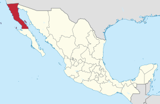
Baja California (Spanish pronunciation: [ˈbaxa kaliˈfoɾnja];, officially the Free and Sovereign State of Baja California, is a state in Mexico. It is the northernmost and westernmost of the 32 federal entities of Mexico. Before becoming a state in 1952, the area was known as the North Territory of Baja California. It has an area of 70,113 km2 and comprises the northern half of the Baja California Peninsula, north of the 28th parallel, plus oceanic Guadalupe Island. The mainland portion of the state is bordered on the west by the Pacific Ocean; on the east by Sonora, the U.S. state of Arizona, and the Gulf of California; on the north by the U.S. state of California; and on the south by Baja California Sur.

Durango, officially named Free and Sovereign State of Durango, is one of the 31 states which make up the 32 Federal Entities of Mexico, situated in the northwest of the country. With a population of 1,832,650, Durango has Mexico's second-lowest population density, after Baja California Sur. The capital city, Victoria de Durango, is named after the first president of Mexico, Guadalupe Victoria.

The State of Mexico, officially Mexico, is one of the 32 federal entities of the United Mexican States. It is the most populous, as well as the most densely populated state. It is divided into 125 municipalities and its capital city is Toluca de Lerdo.

Culiacán, officially Culiacán Rosales, is a city in northwestern Mexico that is the capital of and the largest city in Sinaloa and in the Culiacán Municipality. It was founded on September 29, 1531 by the Spanish conquerors Lázaro de Cebreros and Nuño Beltrán de Guzmán under the name of Villa de San Miguel, which referred to its patron saint, Michael the Archangel.

The Adams–Onís Treaty of 1819, also known as the Transcontinental Treaty, the Florida Purchase Treaty, or the Florida Treaty, was a treaty between the United States and Spain in 1819 that ceded Florida to the U.S. and defined the boundary between the U.S. and New Spain. It settled a standing border dispute between the two countries and was considered a triumph of American diplomacy. It came in the midst of increasing tensions related to Spain's territorial boundaries in North America against the United States and the United Kingdom in the aftermath of the American Revolution; it also came during the Latin American wars of independence.

The Gila River is a 649-mile (1,044 km)-long tributary of the Colorado River flowing through New Mexico and Arizona in the United States. The river drains an arid watershed of nearly 60,000 square miles (160,000 km2) that lies mainly within the U.S., but also extends into northern Sonora, Mexico. Indigenous peoples have lived along the river for at least 2,000 years, establishing complex agricultural societies before European exploration of the region began in the 16th century. However, European Americans did not permanently settle the Gila River watershed until the mid-19th century.
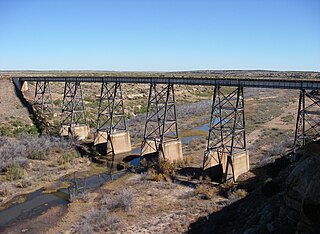
The Canadian River is the longest tributary of the Arkansas River in the United States. It is about 906 miles (1,458 km) long, starting in Colorado and traveling through New Mexico, the Texas Panhandle, and Oklahoma. The drainage area is about 47,700 square miles (124,000 km2).
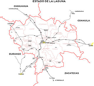
The Comarca Lagunera or La Comarca de la Laguna is a region of northern Mexico occupying large portions of the states of Durango and Coahuila, with rich soils produced by periodic flooding of the Nazas and Aguanaval rivers. Neither river drains into either the Pacific Ocean or the Gulf of Mexico, but rather they created a series of inland lakes. The region was developed for large-scale irrigated cotton agriculture. During the Mexican Revolution, the region was the site of fierce fighting. Following the military phase of the Revolution, the region was part of the agrarian reform under President Lázaro Cárdenas. The dam named for Cárdenas now controls flooding of the rivers, but the groundwater resources are no longer recharged as a result. It is the 8th largest metropolitan area in Mexico.

The San Antonio River is a major waterway that originates in central Texas in a cluster of springs in midtown San Antonio, about 4 miles north of downtown, and follows a roughly southeastern path through the state. It eventually feeds into the Guadalupe River about 10 miles from San Antonio Bay on the Gulf of Mexico. The river is 240 miles long and crosses five counties: Bexar, Goliad, Karnes, Refugio, and Wilson.
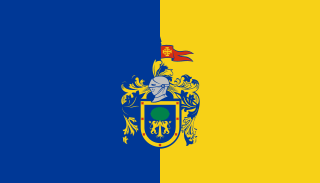
Jalisco, officially the Free and Sovereign State of Jalisco, is one of the 32 states which comprise the Federal Entities of Mexico. It is located in Western Mexico and is bordered by six states which are Nayarit, Zacatecas, Aguascalientes, Guanajuato, Michoacán, and Colima. Jalisco is divided into 125 municipalities, and its capital city is Guadalajara.
