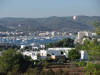
Sant Antoni de Portmany, or simply Sant Antoni, is a town on the western coast of Ibiza, the second-largest town and municipality on the island. It is situated on Sant Antoni Bay on the west coast of the island, part of the Spain autonomous community of the Balearic Islands.

Porthcawl ( ) is a town and community in the Bridgend County Borough of Wales. It is on the south coast of Wales, 25 miles (40 km) west of Cardiff and 19 miles (31 km) southeast of Swansea.

Puerto Escondido is a small port and tourist center in the municipality of San Pedro Mixtepec Distrito 22 in the Mexican state of Oaxaca. Prior to the 1930s, there was no town. The bay had been used as a port intermittently to ship coffee, but there was no permanent settlement due to the lack of potable water. The name "Puerto Escondido" had roots in the legend of a woman who escaped her captors and hid here. The Nahuatl word for this area was Zicatela, meaning “place of large thorns". Today, it refers to the area's most famous beach.
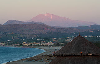
Georgioupoli is a resort village and former municipality in the Chania regional unit, Crete, Greece. Since the 2011 local government reform it is part of the municipality Apokoronas, of which it is a municipal unit. The municipal unit has an area of 53.498 km2 (20.656 sq mi). It is located 39 kilometres east of Chania, about 23 km (14 mi) west of Rethymno and about 100 km (62 mi) west of Heraklio. It was named after Prince George of Greece, high commissioner of the island in the last years of Ottoman occupation.

Alcúdia (Catalan pronunciation:[əlˈku.ði ]) is a municipality and township of the Spanish autonomous community of the Balearic Islands. It is the main tourist centre in the North of Majorca on the eastern coast. It is a large resort popular with tourists. Most of the hotels are located in Port d'Alcúdia and Platja d'Alcúdia, along the 14 km-long (8.7 mi) beach that stretches all the way to Ca'n Picafort. In Alcúdia, the old town is well preserved with houses dating back to the 13th century. The old town is surrounded by a medieval wall.

L'Estartit is a small town and seaside resort on the Costa Brava, part of the municipality of Torroella de Montgrí in the Baix Empordà county, Girona province, autonomous community of Catalonia, Spain. The town is situated between the foothills of the Montgrí Massif and the Mediterranean Sea.
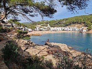
Tamariu is one of three coastal towns belonging to the municipality of Palafrugell, province of Girona, Spain, the other two being Calella de Palafrugell and Llafranc. It is part of the Costa Brava, the coastal region of northeastern Catalonia, in the comarca of Baix Empordà. It is situated about 70 mi (110 km) south of the border with France and close to the nearby inland towns of Palafrugell and Begur.
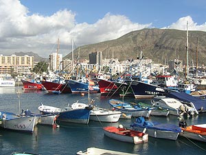
Los Cristianos is a town in Spain with a population of 21,235 (2017), situated on the south coast of the Canary Island of Tenerife. Located in the municipality of Arona between the cone of the mountain Chayofita and the greater mountain Guaza. The town centre is around the Los Cristianos bay, but is rapidly expanding inland with modern development. The town is a popular tourist resort and includes a ferry port and two beaches.

Banyalbufar is a municipality on the Spanish Balearic island of Majorca. The town of the same name is the administrative seat of the municipality. It borders the municipalities of Estellencs, Puigpunyent, Esporles, and Valldemossa.

Altınkum is a neighbourhood of the municipality and district of Didim, Aydın Province, Turkey. Its population is 5,516 (2022). It is a seaside resort on the Aegean Sea, 123 km from Aydın. It is near the ancient Temple of Apollo and the ruins of the Ionian city of Didyma (Didim).

Port de Pollença is a small town in northern Majorca, Spain, on the Bay of Pollença about 6 km east of Pollença and two kilometres southeast of Cala Sant Vicenç. Cap de Formentor is connected to Port de Pollença via a 13.5 km road.
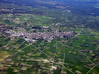
Santa Margalida is a municipality with a population of 10,204 located in the northeast of the Spanish Balearic Island Majorca.

Cala d'Or is a village on the east coast of the island of Mallorca, in the municipality of Santanyí, Balearic Islands, Spain.

Cala Figuera is a district of Santanyí on the island of Majorca, in the Balearic Islands of Spain, around 60 km to the south east of Palma.

Sa Coma is a town on the east coast of the island of Mallorca, Spain. It is close to the towns of Cala Millor and Cala Bona in the municipality of Sant Llorenç des Cardassar. To the south it merges with the small town of S'illot.
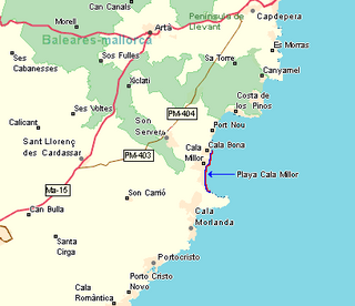
Cala Millor is a town located on the Spanish Balearic Island of Mallorca. It consists of a small bay in the municipalities of Son Servera and Sant Llorenç des Cardassar. Overlooked by Mt. Na Penyal to the west.

Salou is a municipality of the comarca of Tarragonès, in the province of Tarragona, in Catalonia, Spain. The city is approximately 10 km from Tarragona and Reus on the Costa Daurada and 112 km from Barcelona.

Porto Cristo is a small town on the eastern coast of Mallorca. It is 14 km (9 mi) from the town of Manacor and is within the Manacor municipality.

S'illot is a small tourist town on the south east coast of the Balearic Island of Mallorca, Spain, divided between the council areas of Manacor and Sant Llorenç des Cardassar. The two districts are separated by the river Torrent de Ca n'Amer which is spanned by a large bridge in the town. A range of seaside leisure activities take place in the town. At the entrance to the town there is prehistoric settlement that is well preserved.

Cala Comte is a beach in the south west of the Spanish island of Ibiza. It is in the municipality of Sant Josep de sa Talaia and is 5.0 miles (8.0 km) west of the village of Sant Agustí des Vedrà.
