
East Kilbride is the largest town in South Lanarkshire in Scotland, and the country's sixth-largest locality by population. It was also designated Scotland's first new town on 6 May 1947. The area lies on a raised plateau to the south of the Cathkin Braes, about eight miles southeast of Glasgow and close to the boundary with East Renfrewshire.

The Glasgow South Western Line is a mainline railway in Scotland that runs from Glasgow to Kilmarnock, and then either Carlisle via Dumfries, or Stranraer via Ayr, with a branch to East Kilbride.

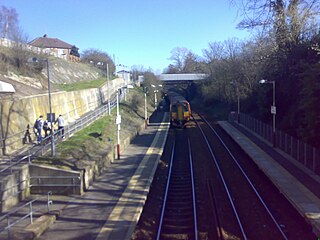
Pollokshaws West railway station is a railway station in Glasgow, Scotland. The station is managed by ScotRail and is served by trains on the Glasgow South Western Line.
Clarkston railway station is a suburban side platform railway station in the town of Clarkston, East Renfrewshire, Scotland. The station is managed by ScotRail and is on the East Kilbride branch of the Glasgow South Western Line. It was opened in 1866 by the Busby Railway.

Busby railway station is a railway station in the village of Busby, East Renfrewshire, Greater Glasgow, Scotland. The station is managed by ScotRail and is on the Glasgow South Western Line 7+1⁄4 miles (11.7 km) south of Glasgow Central towards East Kilbride.

Thorntonhall railway station is a railway station in the village of Thorntonhall, South Lanarkshire, Scotland. The station is managed by ScotRail and is on the Glasgow South Western Line, 8+1⁄2 miles (13.7 km) south of Glasgow Central.

East Kilbride railway station serves the town of East Kilbride, South Lanarkshire, Scotland. The station is managed by ScotRail and it is a terminus on the former Busby Railway. The station is 11+1⁄2 miles (18.5 km) southeast of Glasgow Central.
The Hamilton Branch is a historic railway in Scotland, running from the Newton railway station to Ross Junction with the Caledonian Railway Coalburn Branch.

The A726 road in Scotland is a major route with several distinct sections with different characteristics and names; owing to its stages of construction, since 2005 it has two separate parts, the first running between Strathaven in South Lanarkshire and Junction 5 of the M77 motorway south of Newton Mearns in East Renfrewshire via East Kilbride, and the other running between Junction 3 of the M77 and the M898 motorway near the Erskine Bridge, via Paisley and Junction 29 of the M8 motorway near Glasgow International Airport.

The A727 road in Scotland runs from East Kilbride in South Lanarkshire, through East Renfrewshire, to Junction 3 of the M77 motorway in Glasgow.
The Darvel Branch was an extension of the former Glasgow, Paisley, Kilmarnock and Ayr Railway in Scotland built by the Glasgow and South Western Railway to allow trains to travel between Kilmarnock and Darvel.
The Hamilton and Strathaven Railway was a historic railway in Scotland. It ran from a junction with the Hamilton Branch of the Caledonian Railway to a terminus at Strathaven. The railway was worked from the start by the Caledonian Railway, who absorbed the railway company in 1864.

Eglinton Street railway station was a railway station approximately one mile south of Glasgow Central, in the Port Eglinton district of Glasgow.
Loudounhill was a railway station on the Darvel and Strathaven Railway serving a rural area that included the landmark of Loudoun Hill in the Parish of Galston, East Ayrshire, Scotland.

Strathaven Central or Strathaven was a railway station on the Darvel and Strathaven Railway serving the town of Strathaven in South Lanarkshire, Scotland. The station opened as an extension of the line from Stonehouse and in 1904 was connected with the Hamilton and Strathaven Railway via a link to Strathaven North. It was renamed as 'Strathaven' a few months before closure.

Calderwood Castle was located in East Kilbride, Scotland. The castle was situated near the banks of the Rotten Calder Water in what is now Calderglen Country Park. Most likely constructed in the early to mid fifteenth century by the Maxwell family, the original peel tower collapsed in 1773. It was replaced by an extension to a large 18th-century country house called Calderwood House, which has itself since been demolished along with a later 1840s Gothic Revival addition.
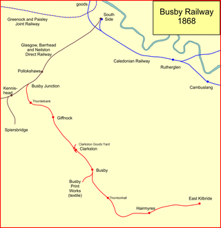
The Busby Railway is a short railway line built to the south of Glasgow, connecting the small villages of Thornliebank, Giffnock, Clarkston and Busby and later Thorntonhall and East Kilbride with the city. It opened in two stages, in 1866 and 1868, and served industry and encouraged residential development.
This article traces the Caledonian Railway branches in South Lanarkshire.

Ravelrig Junction Platform railway station or Ravelrig Halt was originally opened in 1884 as a two platform station on the Shotts line on the edge of the Dalmahoy Estate in an area that now forms part of the city of Edinburgh. It stood just to the west of Ravelrig Junction that served the Balerno Loop Line. After closure in 1920 Ravelrig Platform for Dalmahoy Golf Course was opened at the same site around 1927 as a single platform when the Dalmahoy Estate became a hotel with a golf course, however it is stated to have closed in 1930. The site may have also served a military purpose.

The A724 road in Scotland runs within South Lanarkshire between Rutherglen and Hamilton. It follows an ancient route which is marked on William Roy's Lowland Map of Scotland (1755) with only minor deviations from its modern course.
