Related Research Articles

Liberia, officially the Republic of Liberia, is a country on the West African coast. It is bordered by Sierra Leone to its northwest, Guinea to its north, Ivory Coast to its east, and the Atlantic Ocean to its south and southwest. It has a population of around 5 million and covers an area of 43,000 square miles (111,369 km2). The country's official language is English; however, over 20 indigenous languages are spoken, reflecting the country's ethnic and cultural diversity. The capital and largest city is Monrovia.

The president of the Republic of Liberia is the head of state and government of Liberia. The president serves as the leader of the executive branch and as commander-in-chief of the Armed Forces of Liberia.

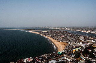
Monrovia is the capital city of the West African country of Liberia. Founded in 1822, it is located on Cape Mesurado on the Atlantic coast and as of the 2022 census had 1,761,032 residents, home to 33.5% of Liberia’s total population. Its Metro Area including Montserrado and Margibi counties largely being urbanized, was home to 2,225,911 inhabtants as of the 2022 census. As the nation's primate city, Monrovia is the country's economic, financial and cultural center; its economy is primarily centered on its harbor and its role as the seat of Liberian government.

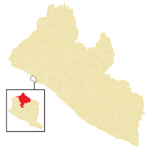
Montserrado County is a county in the northwestern portion of the West African nation of Liberia containing its national capital, Monrovia. One of 15 counties that comprise the first-level of administrative division in the nation, it has 17 sub political districts. As of the 2022 Census, it had a population of 1,920,914, making it the most populous county in Liberia. The area of the county measures 1,912.7 square kilometres (738.5 sq mi), the smallest in the country. Bensonville serves as the capital.
Greater Monrovia is one of four districts located in Montserrado County, Liberia. It contains the country's capital Monrovia. It recorded a population of 970,824 in the 2008 census.
Edina is a city in District 1 of Grand Bassa County, Liberia. Located on the central portion of the Atlantic Coast of Liberia on the north shore of the mouth of the St. John River, it is about 3.5 miles (5.6 km) north of Grand Bassa's capitol of Buchanan. Settled in 1832, Samuel A.L. Johnson has been the city's mayor since 2018. The community is named after Edinburgh, Scotland, which provided monetary support for the foundation of the settlement.
West Point is a township of the Liberian capital city of Monrovia, located on a 0.53 km2 peninsula which juts out into the Atlantic Ocean between the Mesurado and Saint Paul rivers. West Point is one of Monrovia's most densely populated slums.
Clay-Ashland is a township located 10 miles (16 km) from the capital city of Monrovia in Liberia. The town is in the St. Paul River District of Montserrado County. It is named after Henry Clay — a slaveowner and American Colonization Society co-founder who favored gradual emancipation — and his estate Ashland in Lexington, Kentucky.

New Georgia is a township in Montserrado County, Liberia that was first settled by Africans who had been taken from slave ships seized or wrecked near the United States and then sent to Liberia after several years had passed.

The Ministry of Foreign Affairs is a cabinet ministry of Liberia responsible for directing Liberia's external relations and the management of its international diplomatic missions. The ministry is located in Monrovia, Liberia's capital.
Chocolate City is a central-northern suburb of Monrovia, Liberia. It is located in the New Georgia Township. Chocolate City contains the Elizabeth Blunt School and Francis Freeman Elementary School.
New Kru Town is a northwestern coastal suburb of Monrovia, Liberia.
Senate elections were held in Liberia on 20 December 2014, with half the seats in the Senate up for election.
The following is a timeline of the history of the city of Monrovia, Liberia.

Gbehzohngar Milton Findley is a Liberian politician and businessman. He is a former President Pro Tempore of the Liberian Senate and also the Minister of Foreign Affairs in the administration of President Weah until 28th July 2020.
Key & Death Hole is a community in the township of Congo Town, Greater Monrovia District, Liberia. The community is located on the eastern, i.e. Old Road, side of the Spriggs Payne Airport. The name Death Hole stems from massacres of the Liberian Civil War, occurring near the airfield in 1990. An alternative name for the area is Tweh-Johnsonville, after Matthew Tweh and Rt. Gen. J. Samuel Johnson.
Dixville is a township in Greater Monrovia District, Montserrado County, Liberia. The Dixville township was one of five townships founded in the second wave of colonization, between 1828 and 1847.
Montserrado-11 is an electoral district for the elections to the House of Representatives of Liberia. The district covers the eastern parts of Caldwell township, all of Dixville township, parts of Barnersville township and four communities of the Gardnersville township.

Montserrado-15 is an electoral district for the elections to the House of Representatives of Liberia. The district covers the northern parts of Garwolon Township, i.e. the communities of Blamo Town, Central Logan Town, Free Port Development, Gbandi Town, King Peter Town, Little White Chapel, Vicky Spot, Zinc Camp and Zondo Town, as well as the western parts of Caldwell Township, i.e. Caldwell Community, New Georgia Road, Central Caldwell and Lower Caldwell A.

The Garworlohn Township is a township of the Greater Monrovia District, Montserrado County, Liberia. It is located on Bushrod Island, and stretches from Vai Town in the south to Bong Mines Bridge in the north. Politically, Garworlohn Township is divided between the Montserrado-13, Montserrado-14 and Montserrado-15 electoral districts.
References
- ↑ Rural Africana. African Studies Center, Michigan State University. 1971. p. 80.
- ↑ The Constitution of the Commonwealth of Liberia [usurped] . Accessed: 23 March 2015.
- ↑ "The African Repository". American Colonization Society. 2 July 1868 – via Google Books.
- ↑ Executive Mansion. President Weah Makes further Appointments in Government Archived 14 July 2020 at the Wayback Machine
- 1 2 National Electoral Commission. Montserrado County Electoral District No.15 2017
- 1 2 National Electoral Commission. Montserrado County Electoral District No.11 2017
- ↑ Liberia Institute of Statistics and Geo-Information Services. Population 2008, 2014 by County, District, Clan and Households, Liberia Archived 13 July 2020 at the Wayback Machine
6°24′N10°44′W / 6.400°N 10.733°W
| International | |
|---|---|
| National | |