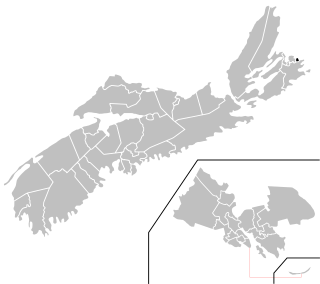
Glace Bay-Dominion is a provincial electoral district in Nova Scotia, Canada, that elects one member of the Nova Scotia House of Assembly.

CKPE-FM is a Canadian radio station broadcasting from Sydney, Nova Scotia at 94.9 FM. The station broadcasts a classic hits format branded as 94.9 The Wave. The station has been on the air since 1957 under the original call sign CJCB-FM.

CHER-FM is a Canadian radio station broadcasting from Sydney, Nova Scotia, at 98.3 FM. The station broadcasts a classic rock format branded as Max 98.3, although some current rock songs can be played on this station. The station is owned and operated by the Maritime Broadcasting System.
Donkin is a Canadian rural village with a population of 532 as of 2021. Located on the picturesque coastline of Nova Scotia's Cape Breton Island, it is a part of the Cape Breton Regional Municipality. The smaller communities of Port Caledonia and Schooner Pond are directly adjacent to the village proper, connected by a single strip of road called the Donkin Highway.
Caledonia is a small community in the Canadian province of Nova Scotia, located in the Municipality of the District of Saint Mary's in Guysborough County.

Port Caledonia is a small community in the Canadian province of Nova Scotia, located in the Cape Breton Regional Municipality on Cape Breton Island. It is located on the Donkin Highway, between the town of Glace Bay and the village of Donkin.
Bateston is a community in the Canadian province of Nova Scotia, located in the Cape Breton Regional Municipality on Cape Breton Island. It is known for its flashing light at the center of town.

Mira Gut is a small community in the Canadian province of Nova Scotia, located in the Cape Breton Regional Municipality on Cape Breton Island where the Mira River enters into Mira Bay. It features both fresh and saltwater beaches and is a popular swimming area during the summer months.
Passchendaele is a community that is part of the former town of Glace Bay in the Canadian province of Nova Scotia, located in the Cape Breton Regional Municipality on Cape Breton Island.
Leitches Creek Station is a community in the Canadian province of Nova Scotia, located in the Cape Breton Regional Municipality on Cape Breton Island.
Lower Caledonia is a small community in the Canadian province of Nova Scotia, located in the Municipality of the District of Saint Mary's in Guysborough County. The population of Lower Caledonia is unknown because it has not been included in any of the StatCan census counts.
Homeville is a community in the Canadian province of Nova Scotia, located in the Cape Breton Regional Municipality.
Birch Grove is a community in the Canadian province of Nova Scotia, located in the Cape Breton Regional Municipality on Cape Breton Island.
Catalone Gut is a community in the Canadian province of Nova Scotia, located in the Cape Breton Regional Municipality on Cape Breton Island. It is named after Gédéon de Catalogne, a French officer, who was a cartographer stationed at the Fortress of Louisbourg.
Round Island is a community in the Canadian province of Nova Scotia, located in the Cape Breton Regional Municipality on Cape Breton Island.
Table Head is a Neighborhood in the Canadian province of Nova Scotia, located in Glace Bay in the Cape Breton Regional Municipality on Cape Breton Island.
Scatarie Island is an island in the Canadian province of Nova Scotia, located off the coast of Baleine, Cape Breton Island.

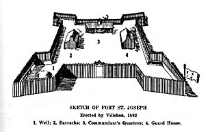
Fort Nashwaak was the capital of Acadia and is now a National Historic Site of Canada in present-day Fredericton, New Brunswick, Canada. It was located strategically up the Saint John River and close to the native village of Fort Meductic for military purposes.

A township in Nova Scotia, Canada, was an early form of land division and local administration during British colonial settlement in the 18th century. They were created as a means of populating the colony with people loyal to British rule. They were typically rural or wilderness areas of around 100,000 acres (400 km2) that would eventually include several villages or towns. Some townships, but not all, returned a member to the General Assembly of Nova Scotia; others were represented by the members from the county. Townships became obsolete by 1879 by which time towns and counties had become incorporated.
Caledonia was launched in Philadelphia in 1779, possibly under another name. Caledonia first appeared in British records in 1800. She traded with the Baltic and Canada. Then in 1814 United States privateers captured her twice. The first time the privateer released Caledonia; the second time the Royal Navy recaptured her. She returned to trading with Canada until she was wrecked in September 1824.


