This article needs additional citations for verification .(November 2022) |
Callahan City is a ghost town in Callahan County, Texas, United States.
This article needs additional citations for verification .(November 2022) |
Callahan City is a ghost town in Callahan County, Texas, United States.
Founded in 1876, Callahan City was envisioned as a center of commerce and government for the then quite sparsely populated Callahan County. Located along the Western Trail to Dodge City, the community hosted several merchants who served the trail drivers who passed through the area along with more than 100,000 head of cattle through the mid to late 1870s.
Though a spot of some local importance, Callahan City's relatively remote location hindered its growth; local merchants often had to wait a month or more for goods to be freighted in from Fort Worth. The community was dealt a severe blow in December 1877 when it lost the county seat to neighboring Belle Plain in a hotly contested election. In 1880, Callahan City was bypassed by the railroad, and the few remaining residents dispersed leaving the town all but abandoned. Today, the former cemetery is all that remains of the community.

Pecos County is a county located in the U.S. state of Texas. As of the 2020 census, its population was 15,193. The county seat is Fort Stockton. The county was created in 1871 and organized in 1875. It is named for the Pecos River. It is one of the nine counties that comprise the Trans-Pecos region of West Texas.

Minco is a city in Grady County, Oklahoma, United States. The population was 1,632 at the 2010 census.

Wagoner is a city in Wagoner County, Oklahoma, United States. The population was 8,323 at the 2010 census, compared to the figure of 7,669 recorded in 2000. It is the county seat of Wagoner County. Wagoner became the first city incorporated in Indian Territory on January 4, 1896.

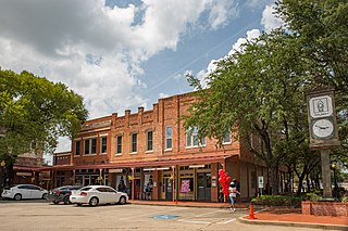
Baird is a city and the county seat of Callahan County, Texas, United States. Its population was 1,496 at the 2010 census. The city is named after Matthew Baird, the owner and director of the Texas and Pacific Railway. The railway depot is now operated as the visitor center and a transportation museum.
Lancaster is a city in Dallas County, Texas, United States. Its population was 41,275 according to the 2020 census. Founded in 1852 as a frontier post, Lancaster is one of Dallas County's earliest settlements. Today, it is a suburban community located in the Dallas–Fort Worth metroplex, about 15 mi (24 km) south of downtown Dallas.

Ennis is a city in eastern Ellis County, Texas. It is on the edge of the blackland prairie region of Texas. The population is 20,159 according to the 2020 census, with an estimated population of 21,210 in 2021. Ennis is home to the annual National Polka Festival.

Canadian is a city in, and the county seat of, Hemphill County, Texas, United States. The population was 2,649 at the 2010 census, up from 2,233 in 2000. It is named for the nearby Canadian River, a tributary of the Arkansas River. Incorporated in 1908, Canadian is sometimes called "the oasis of the High Plains". Canadian is on the eastern side of the Texas Panhandle, close to the border with Oklahoma.

Sulphur Springs is a city in and the county seat of Hopkins County, Texas, United States. As of the 2010 census, its population was 15,449. Sulphur Springs is located along the western edge of Northeast Texas.

Seabrook is a city in Harris County in the U.S. state of Texas, with some water surface area located within Chambers County. The population was 11,952 at the 2010 U.S. census, and 14,149 in 2019. Several fish markets line the city's waterfront, while antique shops and bed and breakfast establishments are found in the city's downtown area. The city is home to several miles of trails, which connect multiple city parks to each other.

Rowlett is a city in Dallas and Rockwall counties in the U.S. state of Texas, and an eastern suburb of Dallas. The total population estimate is 73,270 in 2021. It is a growing, upscale community with nearly $1.5 billion in development in the Dallas–Fort Worth metroplex, located on Lake Ray Hubbard.

The Santa Fe Trail was a 19th-century route through central North America that connected Franklin, Missouri, with Santa Fe, New Mexico. Pioneered in 1821 by William Becknell, who departed from the Boonslick region along the Missouri River, the trail served as a vital commercial highway until 1880, when the railroad arrived in Santa Fe. Santa Fe was near the end of El Camino Real de Tierra Adentro which carried trade from Mexico City. The trail was later incorporated into parts of the National Old Trails Road and U.S. Route 66.
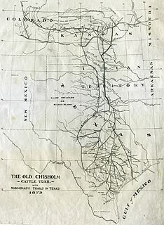
The Chisholm Trail was a trail used in the post-Civil War era to drive cattle overland from ranches in Texas to Kansas railheads. The trail was established by Black Beaver, a Lenape guide and rancher, and his friend Jesse Chisholm, a Cherokee merchant. They collected and drove numerous cattle along the trail to Kansas, where they could be shipped east to achieve higher prices. The southern terminus was Red River Station, a trading post near the Red River along the northern border of Texas. The northern terminus was a trading post near Kansas City, Kansas. Chisholm owned both of these posts. In the years of the cattle drives, cowboys would drive large herds from ranches across Texas to the Red River Station and then north to Kansas City.

Bolivar is an unincorporated community in northern Denton County, Texas, United States, at the intersection of Farm Roads 2450 and 455, 14 miles northwest of Denton, on Clear Creek.

The Great Western Cattle Trail was used during the late 19th century for movement of cattle and horses to markets in eastern and northern states. It is also known as the Western Trail, Fort Griffin Trail, Dodge City Trail, Northern Trail and Texas Trail. It replaced the Chisholm trail when that closed. While it wasn't as well known, it was greater in length, reaching railheads up in Kansas and Nebraska and carried longhorns and horses to stock open-range ranches in the Dakotas, Wyoming, Montana, and two provinces in Canada. It took almost one hundred days to reach their destination.
Belcherville is a city along U.S. Route 82 and Farm to Market Road 1816 in Montague County, Texas, United States. The population is less than 50.
Lebanon was the name of two different communities that were founded in Texas in the 19th Century, neither of which exists today. The first was a town located in Collin County that had a post office designated as Lebanon, Texas, before it was relocated to Frisco, Texas. The second was a smaller unincorporated community located in Live Oak County of which only a cemetery remains today.

U.S. Route 301 in Florida runs from the Sarasota-Bradenton-Venice, Florida Metropolitan Statistical Area northeast to the Greater Jacksonville Metropolitan Area. The road is a spur of U.S. Route 1, which it intersects in Callahan.

The Austin–Round Rock–San Marcos metropolitan statistical area is a five-county metropolitan area in the U.S. state of Texas, as defined by the Office of Management and Budget. The metropolitan area is situated in Central Texas on the western edge of the American South and on the eastern edge of the American Southwest, and borders Greater San Antonio to the south.

Montopolis is a neighborhood in Austin, Texas. Located southeast of the city's urban core, Montopolis is in ZIP code 78741. Montopolis is bounded by Lake Lady Bird on the north, by Grove Street and the Pleasant Valley neighborhood on the west, to the south by Texas State Highway 71, and by U.S. Route 183 on the east. The southeast corner abuts Austin-Bergstrom International Airport. Montopolis is in City Council District 3.
Cattle towns were midwestern frontier settlements that catered to the cattle industry. The economies of these communities were heavily dependent on the seasonal cattle drives from Texas, which brought the cowboys and the cattle that these towns relied upon. Cattle towns were found at the junctions of railroads and livestock trails. These towns were the destination of the cattle drives, the place where the cattle would be bought and shipped off to urban meatpackers, midwestern cattle feeders, or to ranchers on the central or northern plains. Cattle towns were made famous by popular accounts of rowdy cowboys and outlaws who were kept under control by local lawmen, but those depictions were mostly exaggeration and myth.
The Handbook of Texas Online entry for Callahan City
Municipalities and communities of Callahan County, Texas, United States | ||
|---|---|---|
| Cities |  | |
| Towns | ||
| Unincorporated communities | ||
| Ghost towns | ||
| | This article about a location in Callahan County, Texas is a stub. You can help Wikipedia by expanding it. |
| | This United States ghost town-related article is a stub. You can help Wikipedia by expanding it. |