
The California Department of Transportation (Caltrans) is an executive department of the U.S. state of California. The department is part of the cabinet-level California State Transportation Agency (CalSTA). Caltrans is headquartered in Sacramento.

The Los Angeles County Metropolitan Transportation Authority (LACMTA), branded as Metro, is the county agency that plans, operates, and coordinates funding for most of the public transportation system in Los Angeles County, California, the most populated county in the United States. The agency directly operates a large transit system that includes bus, light rail, heavy rail (subway), and bus rapid transit services; and provides funding for transit it does not operate, including Metrolink commuter rail, municipal bus operators and paratransit services. Metro also provides funding and directs planning for railroad and highway projects within Los Angeles County. In 2022, the system had a total ridership of 255,250,500 and had a ridership of 890,100 per weekday as of the second quarter of 2023. It is the single largest transit agency within the county as well.

Downtown Los Angeles (DTLA) contains the central business district of Los Angeles. In addition, it contains a diverse residential area of some 85,000 people, and covers 5.84 sq mi (15.1 km2). A 2013 study found that the district is home to over 500,000 jobs. It is also part of Central Los Angeles.

Route 110, consisting of State Route 110 (SR 110) and Interstate 110 (I-110), is a state and auxiliary Interstate Highway in the Los Angeles metropolitan area of the US state of California. The entire route connects San Pedro and the Port of Los Angeles with Downtown Los Angeles and Pasadena. The southern segment from San Pedro to I-10 in downtown Los Angeles is signed as I-110, while the northern segment to Pasadena is signed as SR 110. The entire length of I-110, as well as SR 110 south of the Four Level Interchange with US Route 101 (US 101), is the Harbor Freeway, and SR 110 north from US 101 to Pasadena is the historic Arroyo Seco Parkway, the first freeway in the western United States.

Route 710, consisting of the non-contiguous segments of State Route 710 (SR 710) and Interstate 710 (I-710), is a major north–south state highway and auxiliary Interstate Highway in the Los Angeles metropolitan area of the U.S. state of California. Also called the Los Angeles River Freeway prior to November 18, 1954, the highway was initially planned to connect Long Beach and Pasadena, but a gap in the route exists from Alhambra to Pasadena through South Pasadena due to community opposition to its construction.
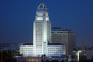
Los Angeles City Hall, completed in 1928, is the center of the government of the city of Los Angeles, California, and houses the mayor's office and the meeting chambers and offices of the Los Angeles City Council. It is located in the Civic Center district of downtown Los Angeles in the city block bounded by Main, Temple, First, and Spring streets, which was the heart of the city's central business district during the 1880s and 1890s.
The NoHo Arts District is a community in North Hollywood, Los Angeles, California, that is home to contemporary theaters, art galleries, cafes, and shops. The community is generally bounded by Hatteras Street to the north, Cahuenga Blvd to the east, Tujunga Ave to the west, and Camarillo Street to the south. The area features more than twenty professional theaters, producing new work and classics, diverse art galleries, public art, and professional dance studios. The district also features the largest concentration of music recording venues west of the Mississippi. A Metro Rail station is located here, the North Hollywood station of the B Line and serves as the terminus of the Metro G Line busway.

State Route 118 is a state highway in the U.S. state of California that runs west to east through Ventura and Los Angeles counties. It travels from State Route 126 at the eastern edge of Ventura immediately northwest of Saticoy, then through Saticoy, in Ventura County east to Interstate 210 near Lake View Terrace in Los Angeles. SR 118 crosses the Santa Susana Pass and the northern rim of the San Fernando Valley along its route.
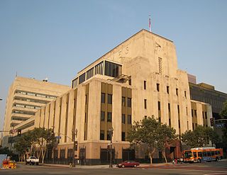
Parker Center, initially named the Police Administration Building or Police Facilities Building, was the former headquarters of the Los Angeles Police Department from 1955 until October 2009. It was located in Downtown Los Angeles at 150 North Los Angeles Street. Often nicknamed "The Glass House", the building was named for former LAPD chief William H. Parker in 1966.

The Civic Center neighborhood of Los Angeles, California, is the administrative core of the City of Los Angeles, County of Los Angeles, and a complex of city, county, state, and federal government offices, buildings, and courthouses. It is located on the site of the former business district of the city during the 1880s and 1890s, since mostly-demolished.

The Los Angeles County Department of Public Works (LACDPW) is responsible for the construction and operation of Los Angeles County's roads, building safety, sewerage, and flood control. DPW also operates traffic signals and intelligent transportation systems, drinking water systems in certain communities, operates five airports, paratransit and fixed route public transport, administers various environment programs, issues various permits for activities in the public roadway, and has a Department Emergency Operations Center that works in conjunction with the County Emergency Operations Center operated by the Sheriff's Department. The department is headquartered at 900 South Fremont Avenue in Alhambra, California.
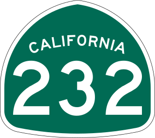
State Route 232 is a state highway in the U.S. state of California that runs along Vineyard Avenue in Ventura County, serving as a connector between US 101 in Oxnard and SR 118 near Saticoy.

The Arts District is a neighborhood on the eastern edge of Downtown Los Angeles, California in the United States. The city community planning boundaries are Alameda Street on the west which blends into Little Tokyo, First Street on the north, the Los Angeles River to the east, and Violet Street on the south. Largely composed of industrial buildings dating from the early 20th century, the area has recently been revitalized, and its street scene slowly developed in the early 21st century. New art galleries have increased recognition of the area amidst the downtown, which is known for its art museums.
J. W. Robinson Co., Robinson's, was a chain of department stores operating in the Southern California and Arizona area, previously with headquarters in Los Angeles, California.
Spring Street in Los Angeles is one of the oldest streets in the city. Along Spring Street in Downtown Los Angeles, from just north of Fourth Street to just south of Seventh Street is the NRHP-listed Spring Street Financial District, nicknamed Wall Street of the West, lined with Beaux Arts buildings and currently experiencing gentrification. This section forms part of the Historic Core district of Downtown, together with portions of Hill, Broadway, Main and Los Angeles streets.
The Biscuit Company Lofts is a 7-story building in Los Angeles, California. Built in 1925 as a factory, the building was converted to live/work lofts in 2006.
Times Mirror Square is a complex of buildings on the block bounded by Spring, Broadway, First and Second streets in the Civic Center district of Downtown Los Angeles. It was headquarters of the Los Angeles Times until 2018. It is currently vacant, with plans being proposed regarding how to best utilize the existing buildings and the total ground area of the site.

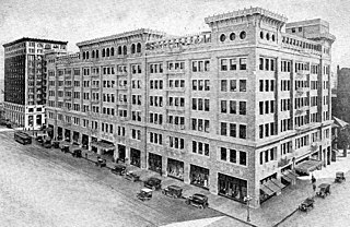
The Blackstone Building is a 1916 structure located at 901 South Broadway in Los Angeles, California. It has been listed as a Los Angeles Historic-Cultural Monument since 2003. The Blackstone Department Store Building is an early example of the work of John B. Parkinson, Los Angeles’ preeminent architect of the early 20th century, who also designed Bullocks Wilshire. The building is clad in gray terra cotta and styled in the Beaux Arts school.

Historic Broadway station is an underground light rail station on the A Line and the E Line of the Los Angeles Metro Rail system. It is located at the southeast corner of 2nd Street and Broadway in the Historic Core section of Downtown Los Angeles. In planning documents, the station was originally going to be named 2nd St/Broadway.


