Cambridge Main Street Bridge | |
|---|---|
 Cambridge Main Street Bridge | |
| Coordinates | 43°21′32″N80°19′00″W / 43.3588°N 80.3166°W |
| Carries | Motor vehicles Pedestrians and bicycles |
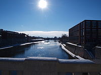
| Crosses | Grand River |
| Locale | Cambridge, Ontario |
| Characteristics | |
| Design | Bowstring arch bridge |
| Total length | 57.3 m (188 ft) |
| History | |
| Designer | Archibald C. Crealock |
| Opened | December 22, 1931 |
| Statistics | |
| Toll | Free both ways |
| Location | |
 | |
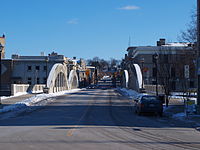
The Cambridge Main Street Bridge is a concrete bowstring arch bridge located in Cambridge, Ontario. It cost approximately $55,000 and was built by W.H. Yates Construction Company Limited, with Archibald C. Crealock listed as the principal designer. Construction lasted throughout 1931 and the official opening was held on December 22, 1931.
Contents
The bridge has a total length of 57.3 meters (188 feet) and runs from the Melville Street portion of Queens Square on the west side of Galt to Water Street on the east side. There is a single support in the middle, resulting in two spans of approximately 28 meters (92 feet). [1] There are two lanes for vehicular traffic and sidewalks on either side for pedestrians.