
The Jubilee line is a London Underground line that runs between Stanmore in suburban north-west London and Stratford in east London, via the Docklands, South Bank and West End. Opened in 1979, it is the newest line on the Underground network, although some sections of track date back to 1932 and some stations to 1879.

The Northern line is a London Underground line that runs between North London and South London. It is printed in black on the Tube map. It carries more passengers per year than any other Underground line – around 340 million in 2019 – making it the busiest tube line in London. The Northern line is unique on the Underground network in having two different routes through central London, two southern branches and two northern branches. Despite its name, it does not serve the northernmost stations on the Underground, though it does serve the southernmost station at Morden, the terminus of one of the two southern branches.

Camden Town, often shortened to Camden, is an area in the London Borough of Camden, around 2.5 miles (4.1 km) north-northwest of Charing Cross. Historically in Middlesex, it is identified in the London Plan as one of 34 major centres in Greater London.
The River Fleet is the largest of London's subterranean rivers, all of which today contain foul water for treatment. It has been used as a culverted sewer since the development of Joseph Bazalgette's London sewer system in the mid-19th century with the water being treated at Beckton Sewage Treatment Works. Its headwaters are two streams on Hampstead Heath, each of which was dammed into a series of ponds—the Hampstead Ponds and the Highgate Ponds—in the 18th century. At the southern edge of Hampstead Heath these descend underground as sewers and join in Camden Town. The waters flow 4 miles (6 km) from the ponds.

West Norwood Cemetery is a 40-acre (16 ha) rural cemetery in West Norwood in London, England. It was also known as the South Metropolitan Cemetery. One of the first private landscaped cemeteries in London, it is one of the "Magnificent Seven" cemeteries of London, and is a site of major historical, architectural and ecological interest.

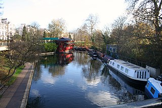
The Camden markets are a number of adjoining large retail markets, often collectively referred to as Camden Market or Camden Lock, located in the historic former Pickfords stables, in Camden Town, London. It is situated north of the Hampstead Road Lock of the Regent's Canal. Famed for their cosmopolitan image, products sold on the stalls include crafts, clothing, books, bric-a-brac, and fast food. It is the fourth-most popular visitor attraction in London, attracting approximately 250,000 people each week.
The WC postcode area, also known as the London WC postcode area, is a group of postcode districts in central London, England. The area covered is of high density development, and includes parts of the City of Westminster and the London Boroughs of Camden and Islington, plus a very small part of the City of London.

Agar Town was a small, historically poor neighbourhood of St Pancras in central London. Most of the area was demolished making way for St Pancras railway station.

Chalk Farm Road is a street in the Camden Town area of London. There is a widespread misapprehension that the road that runs through Camden Market is part of Camden High Street, but it is actually Chalk Farm Road. Camden Market is a major centre for the retailing of street fashions and other goods targeted at teenagers and young adults, and Chalk Farm Road has an alternative culture atmosphere.

York Way is a major road in the London Borough of Islington, running north for one mile from the junction of Pentonville Road and Euston Road, adjacent to King's Cross railway station towards Kentish Town and Holloway. At its northern end, the road becomes Brecknock Road. For its entire length York Way forms the boundary between the London Boroughs of Islington and Camden.
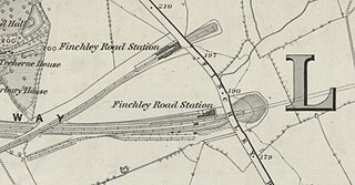
Finchley Road railway station was built by the Midland Railway (MR) in 1868 on its extension to St. Pancras. Situated at the north end of the Belsize Tunnels, it served the newly developed area of St John's Wood.

Royal College Street is a major thoroughfare in London, England, within the St Pancras and Somers Town ward in the Borough of Camden. The street, which is one-way, is home to the London headquarters of Parcelforce and the London campus of the Royal Veterinary College, a constituent college of the University of London.
Cumberland Basin was a canal basin near to Euston railway station in London, England and a part of the Regent's Canal. It was originally known as Jew's Harp Basin in the 1880s, after a nearby public house.

The city of London, England, has several catacomb spaces, although the high water table limits subterranean construction. There has been a long tradition of burial under the floors of churches, and during the period of new church construction in the Victorian era many were provided with vaults or crypts under the main structure.

The Jubilee Greenway is a walking and cycling route in London, England. It was completed in 2012 to mark the Diamond Jubilee of Elizabeth II. The 60 kilometres (37 mi) route of continuous paths links 2012 Olympic and Paralympic venues with parks, waterways and other attractions.
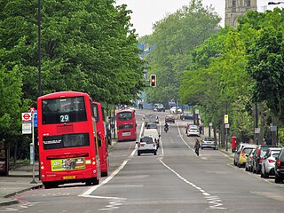
Camden Road is a main road in London running from the junction of Camden High Street and Camden Town Underground station up to Holloway Road. It is part of the A503 which continues east as Tollington Road.

The London Borough of Camden is a borough in Inner London, England. Camden Town Hall, on Euston Road, lies 1.4 mi (2.3 km) north of Charing Cross. The borough was established on 1 April 1965 from the former metropolitan boroughs of Holborn, St Pancras and Hampstead.

The InSpiral Lounge was an organic vegan restaurant, eco-café and events venue in Camden Lock, Camden, London, England, overlooking the Regent's Canal and Camden Market until its closure in 2016. It was the trading name of Ekopia Ltd.

Battlebridge Basin is a canal basin in King's Cross, in the London Borough of Islington. It is located off the Regent's Canal.

Sainsbury's supermarket, Camden is an architecturally notable supermarket building in Camden Road, north London, and is part of the J Sainsbury chain. It was designed by Nicholas Grimshaw & Partners and was completed in 1988, on the site of the former Aerated Bread Company Camden Town bakery. In 2019 it became the first purpose built supermarket to be Grade II listed for its futuristic architecture.
