This article needs additional citations for verification .(January 2024) |

Camomile Street is a short street in the City of London, the financial and historic centre of London.
This article needs additional citations for verification .(January 2024) |
Camomile Street is a short street in the City of London, the financial and historic centre of London.
It is a westward continuation of Bevis Marks, linking that street to Houndsditch (via Outwich Street) and a junction with Bishopsgate and Wormwood Street.
The houses on the north side are on the site of the old Wall of London, and in excavations made for the foundations of warehouses in the street, a bastion and other portions of the wall have been found, partly of Roman construction. A tablet on the house at the north-east corner of the street marks the former site of Bishopsgate.
There is no indication as to the origin of the name, and the street seems to have been unnamed in Stow's time. It suggests that the land immediately within the wall was waste and unbuilt on, and was covered with chamomile, which springs up so readily on all unoccupied land to this day.
On the corner of Camomile Street and Bishopsgate is the Heron Tower, a skyscraper completed in 2011 which is the tallest in the City of London and third-tallest in Greater London after the Shard and One Canada Square at Canary Wharf.
In 2022, a relatively high-profile stabbing occurred on Camomile Street in which three people were stabbed after resisted a so-called ‘phone snatch’ robbery. [1] [2]

Bishopsgate was one of the eastern gates in London's former defensive wall. The gate's name is traditionally attributed to Earconwald, who was Bishop of London in the 7th century. It was first built in Roman times and marked the beginning of Ermine Street, the ancient road running from London to York (Eboracum). The gate was rebuilt twice in the 15th and 18th centuries, but was permanently demolished in 1760.
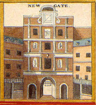
Newgate was one of the historic seven gates of the London Wall around the City of London and one of the six which date back to Roman times. Newgate lay on the west side of the wall and the road issuing from it headed over the River Fleet to Middlesex and western England. Beginning in the 12th century, parts of the gate buildings were used as a gaol, which later developed into Newgate Prison.

King William Street is a street in the City of London, the historic nucleus and modern financial centre of London. It is a two-way street linking Lombard Street, at its northern end, with London Bridge, which marks the start of the start of the A3 route to Portsmouth.

99 Bishopsgate is a commercial skyscraper in London. It is located on Bishopsgate, a major thoroughfare in the City of London financial district. The building is 104 metres (341 ft) tall and has 25 office floors, with a total net lettable floor space of circa 30,000 square metres (322,900 sq ft). There are a further three plant floors at levels LG, 14 and 27.

The Golden Boy of Pye Corner is a small late-17th-century monument located on the corner of Giltspur Street and Cock Lane in Smithfield, central London. It marks the spot where the 1666 Great Fire of London was stopped, whereas the Monument indicates the place where it started. The statue of a naked boy is made of wood and is covered with gold; the figure was formerly winged. The late 19th-century building that incorporates it is a Grade II listed building but listed only for the figure.
The EC postcode area, also known as the London EC postal area, is a group of postcode districts in central London, England. It includes almost all of the City of London and parts of the London boroughs of Islington, Camden, Hackney, Tower Hamlets and Westminster. The area covered is of very high density development. Deliveries for the EC postcode area are made from Mount Pleasant Mail Centre.

Broadgate is a large, 32-acre (13 ha) office and retail estate in the Bishopsgate Without area of the City of London. It is owned by British Land and GIC and managed by Savills.

Houndsditch is a street running through parts of the Portsoken and Bishopsgate Without wards of the City of London; areas which are also a part of the East End of London. The road follows the line of the outside edge of the ditch which once ran outside the London Wall. The road took its name from the section of ditch between Bishopsgate and Aldgate. The name may derive from the widespread dumping of rubbish in this stretch of ditch; relating to the dumping of dead dogs, or the scavenging of the waste by feral dogs.
Wormwood Street is a short street in the City of London which runs between London Wall at its western end and a junction with Bishopsgate and Camomile Street in the east. It is a dual carriageway which forms part of the A1211 route between Barbican and Whitechapel.

Salesforce Tower, 110 Bishopsgate is a commercial skyscraper in London. It stands 230 metres (755 ft) tall including its 28-metre (92 ft) mast making it the second tallest building in the City of London financial district and the fifth tallest in Greater London and the United Kingdom, after the Shard in Southwark and One Canada Square at Canary Wharf. 110 Bishopsgate is located on Bishopsgate and is bordered by Camomile Street, Outwich Street and Houndsditch.

St Mary Axe was a medieval parish in the City of London whose name survives as that of the street which formerly occupied it. The Church of St Mary Axe was demolished in 1561 and its parish united with that of St Andrew Undershaft, which is situated on the corner of St Mary Axe and Leadenhall Street. The site of the former church is now occupied by Fitzwilliam House, a fact acknowledged by a blue plaque on the building's façade. Nearby parishes include the medieval Great St Helen's (1210) and St Ethelburga.

St Martin Outwich was a parish church in the City of London, on the corner of Threadneedle Street and Bishopsgate. Of medieval origin, it was rebuilt at the end of the 18th century and demolished in 1874.

100 Bishopsgate consists of two mixed-use buildings in central London. The buildings are situated on the eastern edge of the City of London financial district.

St Botolph's, Billingsgate was a Church of England parish church in London. Of medieval origin, it was located in the Billingsgate ward of the City of London and destroyed by the Great Fire of London in 1666.

St Nicholas Shambles was a medieval church in the City of London, which stood on the corner of Butcher Hall Lane and Newgate Street. It took its name from the Shambles, the butchers area in the west of Newgate Street. The church is first mentioned as St. Nicholas de Westrnacekaria. In 1253 Walter de Cantilupe, Bishop of Worcester granted indulgences to its parishioners.

St Augustine Papey was a mediaeval church in the City of London situated just south of London Wall opposite the north end of St. Mary Axe Street. First mentioned as "Sci augustini pappey", it originally belonged to the Priory of Holy Trinity. By 1430, the emoluments had become so small that it was united with All Hallows-on-the-Wall and in 1442 was appropriated as an almshouse for elderly clergy. At the time of the Dissolution of the Monasteries it was demolished and the site built over. The churchyard was acquired by St Martin Outwich in 1539, and survives to this day on Camomile Street

Long Lane is a main east–west road in Southwark, south London, England.

South Quay Plaza is a residential-led development under construction in Canary Wharf on the Isle of Dogs, London, within the borough of Tower Hamlets, developed by Berkeley Group Holdings and designed by architect Foster + Partners. The site of the development lies to the immediate north of Marsh Wall and to the immediate south of the financial district Canary Wharf. The entire development is scheduled for completion in 2028.

The Goodsyard is a proposed development on the site of the former Bishopsgate Goods Yard in Shoreditch, London. It spans the border between the two London boroughs of Hackney and Tower Hamlets. The scheme, which is a joint venture between developers Hammerson and Ballymore, previously included 12 buildings, the tallest of which was planned to be 166-metre (545 ft) tall with 46 floors. In total, 1,356 homes were proposed, as well as offices, retail and workshop space and a 0.97-hectare (2.4-acre) park.
Arbour Square police station was located in Stepney, London. Built in the 1840s by the Metropolitan Police, it became known for holding IRA members and the Kray Twins. It was closed down in 1999 and squatted twice before being redeveloped into apartments.
{{cite web}}: CS1 maint: multiple names: authors list (link)