Wormwood Scrubs, known locally as The Scrubs, is an open space in Old Oak Common located in the north-eastern corner of the London Borough of Hammersmith and Fulham in west London. It is the largest open space in the borough, at 67 hectares, and one of the largest areas of common in London. The eastern part, known as Little Wormwood Scrubs, is cut off by Scrubs Lane and the West London line railway. It has been an open public space since the Wormwood Scrubs Act 1879.

Bishopsgate was one of the eastern gates in London's former defensive wall. The gate's name is traditionally attributed to Earconwald, who was Bishop of London in the 7th century. It was first built in Roman times and marked the beginning of Ermine Street, the ancient road running from London to York (Eboracum). The gate was rebuilt twice in the 15th and 18th centuries, but was permanently demolished in 1760.

The London Wall is a defensive wall first built by the Romans around the strategically important port town of Londinium in c. AD 200, as well as the name of a modern street in the City of London, England.
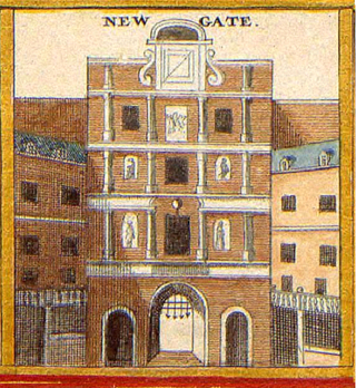
Newgate was one of the historic seven gates of the London Wall around the City of London and one of the six which date back to Roman times. Newgate lay on the west side of the wall and the road issuing from it headed over the River Fleet to Middlesex and western England. Beginning in the 12th century, parts of the gate buildings were used as a gaol, which later developed into Newgate Prison.

St Ethelburga-the-Virgin within Bishopsgate is a Church of England church in the City of London, located on Bishopsgate near Liverpool Street station.

Moorfields was an open space, partly in the City of London, lying adjacent to – and outside – its northern wall, near the eponymous Moorgate. It was known for its marshy conditions, the result of the defensive wall acting as a dam, impeding the flow of the River Walbrook and its tributaries.

Gracechurch Street is a main road in the City of London, the historic and financial centre of London, England, which is designated the A1213.
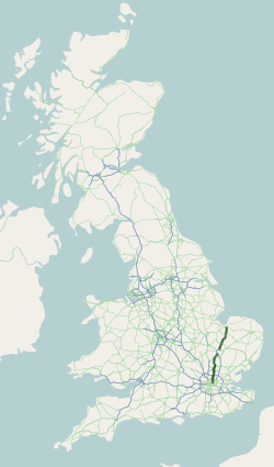
The A10 is a major road in England which runs between The City of London and King's Lynn in Norfolk.

99 Bishopsgate is a commercial skyscraper in London. It is located on Bishopsgate, a major thoroughfare in the City of London financial district. The building is 104 metres (341 ft) tall and has 25 office floors, with a total net lettable floor space of circa 30,000 square metres (322,900 sq ft). There are a further three plant floors at levels LG, 14 and 27.

St Andrew Undershaft is a Church of England church in the City of London, the historic nucleus and modern financial centre of London. It is located on St Mary Axe, within the Aldgate ward, and is a rare example of a City church that survived both the Great Fire of London and the Blitz.

St Anne and St Agnes is a church located at Gresham Street in the City of London, near the Barbican. While St Anne's is an Anglican foundation, from 1966 to 2013 it was let to a congregation of the Lutheran Church in Great Britain.

Bow Road is a closed railway station in Bow, East London, that was opened in 1876 on the Bow Curve branch line by the Great Eastern Railway (GER).
Leadenhall Street is a street in the City of London. It is about 1⁄3-mile-long (0.54 km) and links Cornhill in the west to Aldgate in the east. It was formerly the start of the A11 road from London to Norwich, but that route now starts further east at Aldgate.

Houndsditch is a street running through parts of the Portsoken and Bishopsgate Without wards of the City of London; areas which are also a part of the East End of London. The road follows the line of the outside edge of the ditch which once ran outside the London Wall. The road took its name from the section of ditch between Bishopsgate and Aldgate. The name may derive from the widespread dumping of rubbish in this stretch of ditch; relating to the dumping of dead dogs, or the scavenging of the waste by feral dogs.

St Martin Outwich was a parish church in the City of London, on the corner of Threadneedle Street and Bishopsgate. Of medieval origin, it was rebuilt at the end of the 18th century and demolished in 1874.

Queen Victoria Street, named after the British monarch who reigned from 1837 to 1901, is a street in London which runs east by north from its junction with New Bridge Street and Victoria Embankment in the Castle Baynard ward of the City of London, along a section that divides the wards of Queenhithe and Bread Street, then lastly through the middle of Cordwainer ward, until it reaches Mansion House Street at Bank junction. Beyond Bank junction, the street continues north-east as Threadneedle Street which joins Bishopsgate. Other streets linked to Queen Victoria Street include Puddle Dock, Cannon Street, Walbrook and Poultry.

Camomile Street is a short street in the City of London, the financial and historic centre of London.

The Bishopsgate bombing occurred on 24 April 1993, when the Provisional Irish Republican Army (IRA) detonated a powerful truck bomb on Bishopsgate, a major thoroughfare in London's financial district, the City of London. Telephoned warnings were sent about an hour beforehand, but a news photographer was killed in the blast and 44 people were injured, with fatalities minimised due to its occurring on a Saturday. The blast destroyed the nearby St Ethelburga's church and wrecked Liverpool Street station and the NatWest Tower.
Mile End was a railway station in Bethnal Green, east London, opened in 1841 by the Eastern Counties Railway on its line between the Shoreditch terminus and Coborn Road.

Blomfield Street is a road in the City of London, close to Liverpool Street railway station. It was known as Broker Row, until 1860.
