Related Research Articles

The Oregon Coast is a coastal region of the U.S. state of Oregon. It is bordered by the Pacific Ocean to its west and the Oregon Coast Range to the east, and stretches approximately 362 miles (583 km) from the California state border in the south to the Columbia River in the north. The region is not a specific geological, environmental, or political entity, and includes the Columbia River Estuary.

Cape Blanco is a prominent headland on the Pacific Ocean coast of southwestern Oregon in the United States, forming the westernmost point in the state. Cape Blanco extends farther west than any point of land in the contiguous United States except portions of the Olympic Peninsula in Washington, including Cape Alava, the true westernmost point. The cape is part of Cape Blanco State Park and is the location of the Cape Blanco Light, first lit in 1870.
The Rogue River Wars were an armed conflict in 1855–1856 between the U.S. Army, local militias and volunteers, and the Native American tribes commonly grouped under the designation of Rogue River Indians, in the Rogue River Valley area of what today is southern Oregon. The conflict designation usually includes only the hostilities that took place during 1855–1856, but there had been numerous previous skirmishes, as early as the 1830s, between European American settlers and the Native Americans, over territory and resources.
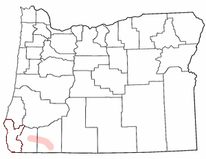
Allegany is an unincorporated community in Coos County, Oregon, United States. It lies at the upstream end of the Millicoma River, where the East Fork Millicoma River and West Fork Millicoma River join to form the main stem, a short tributary of the Coos River. Oregon Route 241 passes through Allegany. The community borders the Elliott State Forest.

Charleston is an unincorporated community in Coos County, Oregon, United States. Charleston is the least populated community in Oregon's Bay Area and is Home to a large commercial fishing fleet, it is adjacent to the ocean entrance to Coos Bay. Charleston is the site of the Oregon Institute of Marine Biology and the United States Coast Guard Charleston Lifeboat Station.

Fort Umpqua was a trading post built by the Hudson's Bay Company in the company's Columbia District, in what is now the U.S. state of Oregon. It was first established in 1832 and moved and rebuilt in 1836.

Cape Arago State Park is a state park in the U.S. state of Oregon, administered by the Oregon Parks and Recreation Department. Cape Arago is north of Bandon and 15 miles southwest of Coos Bay on Cape Arago Highway in Coos County.
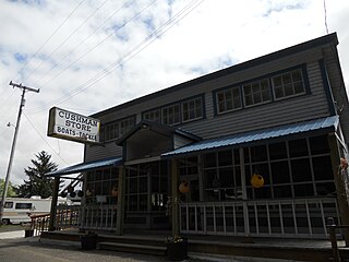
Cushman is an unincorporated community in Lane County, Oregon, United States. It is located on the north bank of the Siuslaw River on Oregon Route 126, between Tiernan and Florence.

Klamath Agency is an unincorporated community in Klamath County, Oregon, United States, on Oregon Route 62 where Agency Creek enters Crooked Creek.
Wyeth is an unincorporated locale in Hood River County, Oregon, United States. It is the site of a campground area in the Columbia River Gorge National Scenic Area off Interstate 84 (I-84).
Libby, previously known as Easport, is an unincorporated community on Coalbank Slough in Coos County, Oregon, United States. It was named for a Native American woman. Its post office was established on June 11, 1890, and operated for just two years. Enoch Gore was postmaster.
Prosper is an unincorporated community in Coos County, Oregon, United States. It is about 3 miles (5 km) northwest of Bandon next to the Coquille River. There is no longer a town at the site.

Sitkum is an unincorporated community in Coos County, Oregon, United States. It is about 27 miles north of Remote in the Southern Oregon Coast Range near the East Fork Coquille River. Sitkum is served by the Myrtle Point post office.
Cooston is an unincorporated community in Coos County, Oregon, United States. It is located on the east shore of Coos Bay across from North Bend, about eight miles from the city of Coos Bay.
Dellwood is an unincorporated community in Coos County, Oregon, United States. It is about 12 miles (19 km) east of Coos Bay, east of Oregon Route 241 on the South Fork Coos River.
The Fort McDermitt Paiute and Shoshone Tribe is a federally recognized tribe of Northern Paiute and Western Shoshone peoples, whose reservation Fort McDermitt Paiute and Shoshone Tribes of the Fort McDermitt Indian Reservation spans the Nevada and Oregon border next to Idaho. The reservation has 16,354 acres (6,618 ha) in Nevada and 19,000 acres (7,700 ha) in Oregon.
Beaver Hill is an unincorporated community in Coos County, Oregon, United States. It is about 12 miles (19 km) south of the city of Coos Bay, east of U.S. Route 101 and west of Oregon Route 42.
Glasgow is an unincorporated community in Coos County, Oregon, United States. For statistical purposes, the United States Census Bureau has defined Glasgow as a census-designated place (CDP). The census definition of the area may not precisely correspond to local understanding of the area with the same name. As of the 2010 census the Glasgow CDP had a population of 763. The place name for Glasgow in the Coos language is Kdet.
Tenmile is an unincorporated community in Coos County, Oregon, United States. It is about 8 miles (13 km) south of Winchester Bay and one mile west of Lakeside, on U.S. Route 101 next to Tenmile Creek and the Oregon Dunes. Tenmile Lake was named for Tenmile Creek, which was said to be ten miles south of Winchester Bay.
Randolph is an unincorporated community in Coos County, Oregon, United States. It is on the north bank the Coquille River about 7 miles (11 km) north of Bandon and about 3 miles east of the Pacific Ocean. Randolph was originally located about three miles to the northwest near the current Whiskey Run Beach, where it was a "black sand" gold mining boomtown in the 1850s. Today that boomtown is a ghost town because there are no significant structures left at the site, but the community on the Coquille River has several homes and a historic cemetery.
References
- ↑ McArthur, Lewis A.; McArthur, Lewis L. (2003) [1928]. Oregon Geographic Names (7th ed.). Portland, Oregon: Oregon Historical Society Press. p. 143. ISBN 978-0875952772.
- ↑ Wells, Gwen. "Contact and Settlement: Settlement Begins". The Oregon History Project. Oregon Historical Society . Retrieved April 15, 2012.
- ↑ Oregon National Guard (State of Oregon, Oregon Military Department) (July 1976). "Forts - Camps - Roads 1805-1976". Oregon State Archives . Retrieved April 15, 2012.
- 1 2 Dodge, Orvil (1898). Pioneer History of Coos and Curry Counties, Oregon. Salem, Oregon: Capital Printing Company. pp. 115–125.
- ↑ McArthur, Lewis A.; McArthur, Lewis L. (2003) [1928]. Oregon Geographic Names (7th ed.). Portland, Oregon: Oregon Historical Society Press. pp. 371–372. ISBN 978-0875952772.
- ↑ Miller, Morris (1852). Letter Report to Major O. Cross, Chief Quartermaster, Pacific Division, U.S. Army, San Francisco. 32nd Congress, 1st Session, Senate Executive Document, No 1. pp. 102–121.
- ↑ Ward, Beverly (1986). White Moccasins. Myrtle Point Printing. p. 47.
- ↑ http://escholarship.org/uc/item/6tt003pf R. Scott Byram, 2013, Triangulating Archaeological Landscapes: The U.S. Coast Survey in California, 1850-1895. Contributions of the Archaeological Research Facility, University of California, Volume 65. ISBN 978-0-9890022-0-2
- ↑ "Camp Castaway". 14 July 2012.
Castronuevo, Agnes F. 2012. Camp Castaway: Indians at First Sight. Published in Voice of CLUSI, September 2012, Issue 9, Vol. 13. Archived at Researchgate: https://www.researchgate.net/publication/259576951_Camp_Castaway_Indians_at_First_Sight