Related Research Articles

Hudspeth County is a county located in the U.S. state of Texas. As of the 2020 census, the population was 3,202. Its county seat is Sierra Blanca, and the largest community is Fort Hancock. The county is named for Claude Benton Hudspeth, a state senator and United States Representative from El Paso. It is northeast of the Mexico–U.S. border.
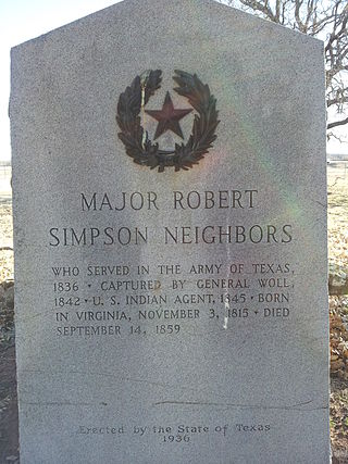
Robert Simpson Neighbors was an Indian agent and Texas state legislator. Known as a fair and determined protector of Indian interests as guaranteed by treaty, he was murdered by a white man named Cornet, whose brother-in-law had been defamed by Neighbors, accusing the brother-in-law a common horse thief, responsible for stealing horses from the reservation Indians. When Neighbors refused to recant the accusation in front of the two men, Cornet shot Neighbors with a shotgun. Cornet was murdered and Murphy acquitted as he did not pull the trigger. Cornet went on the run and was killed during his arrest.
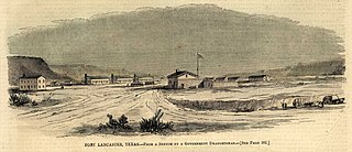
Fort Lancaster is a former United States Army installation located near Sheffield, Texas. The fort was established in 1855 on the San Antonio–El Paso Road to protect migrants moving toward California through Texas. The US Army occupied Fort Lancaster until Texas seceded from the United States in March 1861 and were replaced at the fort by forces loyal to the Confederate States of America. The Confederate Army held the fort from November 1861 until April 1862, when it was again abandoned and then burned.
Howard Draw is a valley that heads in the extreme south of Reagan County, Texas at an elevation of 2720 feet at 30°05′09″N101°22′27″W, and runs through Crockett County to its foot on the Pecos River in Val Verde County, elevation 1575 feet.
The San Antonio–El Paso Road, also known as the Lower Emigrant Road or Military Road, was an economically important trade route between the Texas cities of San Antonio and El Paso between 1849 and 1882. Mail, freight, and passengers traveled by horse and wagon along this road across the Edwards Plateau and dangerous Trans-Pecos region of West Texas.
The San Antonio–San Diego Mail Line, also known as the Jackass Mail, was the earliest overland stagecoach and mail operation from the Eastern United States to California in operation between 1857 and 1861. It was created, organized and financed by James E. Birch the head of the California Stage Company. Birch was awarded the first contract for overland service on the "Southern Route", designated Route 8076. This contract required a semi-monthly service in four-horse coaches, scheduled to leave San Antonio and San Diego on the ninth and the 24th of each month, with 30 days allowed for each trip.

Fort Clark was a frontier fort located just off U.S. Route 90 near Brackettville, in Kinney County, Texas, United States. It later became the headquarters for the 2nd Cavalry Division. The Fort Clark Historic District was added to the National Register of Historic Places on December 6, 1979. The Commanding Officer's Quarters at Fort Clark were designated a Recorded Texas Historic Landmark in 1988. The Fort Clark Guardhouse became a Recorded Texas Historic Landmark in 1962. The Fort Clark Officers' Row Quarters were designated a Recorded Texas Historic Landmark in 1991.
Birchville, or Smith Ranch, now a ghost town, in what is now Hudspeth County, Texas. Birchville was a settlement on the San Antonio-El Paso Road in what was El Paso County. Birchville lay 35 miles northwest of the First Camp on Rio Grande and 24.8 miles southeast of San Elizario, according to the table of distances for the San Antonio-San Diego Mail Line in the Texas Almanac of 1857. Later used as a station on the Butterfield Overland Mail, the distances to the station for that line were given as 241⁄2 miles from San Elizario, 33 miles from Fort Quitman.
The First Crossing of Devils River was the first point at which the Devils River was crossed by the San Antonio-El Paso Road. It was located 10.22 miles west of San Felipe Springs at the mouth of San Pedro Creek on the Devils River. It was 2.54 miles southeast of Painted Caves, on California Creek, a noted camp location on the road. The crossing point and the gorge leading down to it from the east are now submerged under Lake Amistad.
Gillis Springs, formerly Willow Spring, is a historical spring, two miles, (3 km) northwest of California Spring in Val Verde County, Texas.
Howard Springs, was a historical spring, located in the stream channel of Howard Draw at an elevation of 2031 feet, just north of the mouth of Government Canyon at its confluence with Howard Draw in what is now Crockett County, Texas.
Head of Devil's River, a place on the Devils River where it has its confluence with Pecos Canyon at an elevation of 1722 feet, below Beaver Lake, nineteen and a half miles above the second crossing of Devils River. Here the San Antonio-El Paso Road left the Devils River to go northwest, 44 miles across Johnson Draw, Government Canyon and Howard Draw to Howard Springs, then 30.44 miles on to Live Oak Creek and Fort Lancaster, 3 miles further near the Pecos River.
Pecos Canyon, is a tributary of the Devils River in Val Verde County, Texas. It has its source at 30°16′17″N101°09′13″W, 8.6 miles north northwest of Juno, Texas.
Hudson Canyon, is a valley and a tributary ephemeral stream of the Devils River in Val Verde County, Texas. It has its source at 29°57′03″N101°10′38″W at an elevation of 1780 feet. Its mouth has its confluence with Devil's River a short distance below Bakers Crossing at 1499 feet.
Cienega of San Simon, was a cienega, an area of springs 13 miles up the San Simon River from San Simon Station, in Cochise County, Arizona.
Tunas Spring, formerly Escondido Spring, a spring along Tunas Creek, a tributary of the Pecos River in Pecos County, Texas.
Point of Rocks also known as Bald Rock, is a hill and a locale in Jeff Davis County, Texas. Point of Rocks, is an isolated hill with a spring once known as Bald Rock Spring. It was used as a watering place and campsite on the San Antonio-El Paso Road, 10 miles west of Fort Davis, Texas, now Point of Rocks Roadside Park. The elevation of Point of Rocks Spring, is at 5,469 feet / 1,667 meters, at the foot of the southeast slope of the Point of Rocks that reaches over 5,920 feet along its crest.
Limpia Creek, originally known as the Rio Limpia, is a stream that heads in Jeff Davis County, Texas and its mouth is in Pecos County, Texas. Limpa is the Spanish word for "clear or clean water". The creek has its head in the Davis Mountains at an elevation of 7,160 feet, at location 30°38′27″N104°09′42″W on the northeast slope of Mount Livermore. The creek flows 42 miles down Limpia Canyon past Fort Davis and Wild Rose Pass to the canyon mouth, where it turns eastward to its mouth at its confluence with Barrilla Draw, where it disappears into the ground at an elevation of 3,533 feet / 1,077 meters.
Comanche Springs was an aquifer of six artesian springs geographically located between the Edwards Plateau and the Trans-Pecos regions of West Texas. The military fortification Camp Stockton was built around the springs, eventually growing become the city of Fort Stockton.
Pope's Crossing was a ford on the Pecos River located one mile south of the New Mexico–Texas border on the modern Loving–Reeves county line. Discovered by members of an 1855 expedition tasked with drilling artesian wells east of the Pecos led by U.S. Army topographical engineer John Pope, the ford quickly became the primary crossing of the river on the "upper" military or emigrant road between San Antonio and the ford on the Rio Grande opposite the Mexican town of El Paso del Norte. Heavily used by emigrants, soldiers, traders, and freighters eager to avoid the more difficult and unpredictable crossings further south, Pope's Crossing became a well-traveled part of the network of transcontinental wagon roads that developed across Texas in the 1850s to facilitate settlement and commerce in the southwestern lands recently acquired as a result of the Mexican–American War.
References
- ↑ Timothy K. Perttula, The Prehistory of Texas, Texas A&M University Press, 2004, p.278
- ↑ Gunnar M. Brune, Springs of Texas, Volume 1, Texas A&M University Press, 2002, p.451
- 1 2 "Texas Centennial Marker #4744: Camp Hudson, Site of". Texas Historical Commission . Retrieved 6 March 2015.
- 1 2 Julia Cauble Smith, "CAMP HUDSON," Handbook of Texas Online (http://www.tshaonline.org/handbook/online/articles/qbc16), accessed January 28, 2014. Published by the Texas State Historical Association.
- ↑ "Texas Centennial Marker #663: Camp Hudson, C.S.A." Texas Historical Commission . Retrieved 6 March 2015.