
Circle is a census-designated place (CDP) in Yukon-Koyukuk Census Area, Alaska, United States. At the 2010 census the population was 104, up from 100 in 2000.

Stambaugh was a city in Iron County in the U.S. state of Michigan. In the 2000 census, the city population was 1,243.

Stambaugh Township is a civil township of Iron County in the U.S. state of Michigan. The population was 1,248 at the 2000 census.

Hempstead is a city in Waller County, Texas, United States, part of the Houston–The Woodlands–Sugar Land metropolitan area. It serves as the county seat of Waller County.

Camp Shanks was a United States Army installation in the Orangetown, New York. Named after Major General David Carey Shanks (1861–1940), it was situated near the juncture of the Erie Railroad and the Hudson River. The camp was the largest U.S. Army embarkation camp used during World War II.

Great Cities of the Ancient World is a 1972 history book by L. Sprague de Camp, published by Doubleday. A translation into German has also appeared.
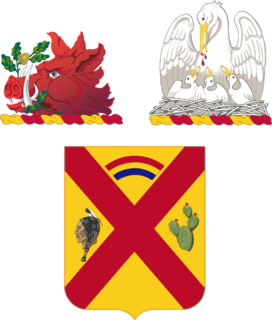
The 108th Cavalry Regiment is a Regiment of the Georgia Army National Guard and the Louisiana Army National Guard respectively
Tincup, or Tin Cup, originally called Virginia City, is an unincorporated community in Gunnison County, Colorado, United States. The community was once a prominent mining town. Tincup is now a community of summer homes with a few year-round residents. Many historic buildings are still in use.

Weaver, or Weaverville, is a former gold mining town, now a deserted ghost town, in Yavapai County, Arizona. All that remains are some rusting mining machinery, a partially restored cemetery, and the ruins of a stone house.
The Battle of Pinos Altos was a military action of the Apache Wars. It was fought on September 27, 1861 between settlers of Pinos Altos mining town, the Confederate Arizona Guards, and Apache warriors. The town is located about seven miles north of the present day Silver City, New Mexico.
Camp Stanford was an American Civil War tent camp established on March 3, 1863 in present day Stockton, California. It was located in the then undeveloped perimeter of the city, occupying two square blocks of land, now bounded by Rose, Acacia, Van Buren and Monroe streets.
The Owens Valley War was fought between 1862 and 1863, by California Volunteers and local settlers against the Owens Valley Paiutes, and their Shoshone and Kawaiisu allies, in the Owens Valley of California and the southwestern Nevada border region. The removal of a large number of the Owens River Native Californians to Fort Tejon in 1863, was considered the end of the war. Minor hostilities continued occasionally until 1867.

The Iron County MRA is a Multiple Resource Area addition to the National Register of Historic Places, which includes 72 separate structures and historic districts within Iron County, Michigan, United States of America. These properties were identified and placed on the Register in 1983, with the exception of one property that was placed on the Register in 1993.
El Dorado Canyon is a canyon in southern Clark County, Nevada famed for its rich silver and gold mines. The canyon was named in 1857 by steamboat entrepreneur Captain George Alonzo Johnson when gold and silver was discovered here. It drains into the Colorado River at the former site of Nelson's Landing.
Camp Low or San Juan Bautista Post, was a military post first established at San Juan Bautista in December 1864 by California Volunteers, in response to the attacks of the Mason Henry Gang in the surrounding area, during the American Civil War. The post was named in honor of the Governor of California Frederick F. Low
Camp Chase, also known as Camp Wilson, was a training camp for Massachusetts militia during the American Civil War located in Lowell, Massachusetts. Several thousand recruits were trained at Camp Chase before being sent south to the battle front.

Pyramid is an unincorporated community in Washoe County, Nevada, United States. At one time, it was a station on the Fernley and Lassen Railway located between Bristol and Big Canyon. At one time there was a post office at this location.

Operation Double Eagle was a US Marine Corps and Army of the Republic of Vietnam (ARVN) operation that took place in southern Quảng Ngãi Province, lasting from 28 January to 17 February 1966, during the Vietnam War. The operation was mounted in conjunction with Operation Masher in northern Bình Định Province. The operation was inconclusive as the People's Army of Vietnam (PAVN) and the Vietcong (VC) had largely slipped away.
Lucky Jim Camp sometimes called Lucky Camp is a ghost town site in Clark County, Nevada. It was within New Mexico Territory when founded in 1862.


