The Lines of Torres Vedras were lines of forts and other military defences built in secrecy to defend Lisbon during the Peninsular War. Named after the nearby town of Torres Vedras, they were ordered by Arthur Wellesley, Viscount Wellington, constructed by Sir Richard Fletcher, 1st Baronet, and his Portuguese workers between November 1809 and September 1810, and used to stop Marshal Masséna's 1810 offensive. The Lines were declared a National Heritage by the Portuguese Government in March 2019.

Oeiras is a municipality in the western part of Lisbon metropolitan area, a subregion of Greater Lisbon, in continental Portugal. It is part of the urban agglomeration of Lisbon, 16 km from the capital. The population in 2011 was 172,120 living in an area of 45.88 km2, making the municipality the fifth-most densely populated in Portugal.

The Castle of Abrantes overlooks the city of Abrantes, in the municipality of Abrantes in the district of Santarém, Ribatejo, divided between the two civil parishes of São João and São Vicente. It was part of the Reconquista fortifications that made up the Linha do Tejo, a line of castles and outposts during the Middle Ages, recently integrated into a tourist region called the Região de Turismo dos Templários.

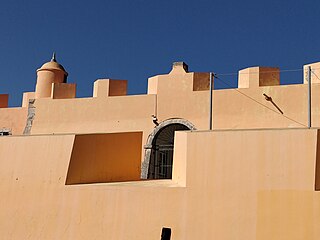
The São Julião da Barra Fort is the largest and most complete military defense complex in the Vauban style remaining in Portugal. It is located in São Julião da Barra, on the point of São Gião, in the parish of Oeiras e São Julião da Barra, Paço de Arcos e Caxias, Lisbon District. Considered in the past as the most important maritime fortification in the country, it had originally, together with the Fort of São Lourenço do Bugio, the role of controlling access to the port of Lisbon. It is currently the official residence of the Portuguese Minister of National Defence.

The Fort of São Lourenço do Bugio, also known as the fort of São Lourenço da Cabeça Seca or simply Torre do Bugio, is located in the middle of the estuary of the river Tagus, near Lisbon in Portugal. With no further need for its military functions, it is presently a lighthouse. The fort’s location is on a sandbank formed by the silting of the river mouth, the result of the meeting of the river’s waters with those of the Atlantic Ocean. Being the only sandbar in the Tagus with its surface above the tide throughout the year, it was given the name “dry head”. The derivation of the name “Bugio” (monkey) is uncertain but may be related to the French word for candle, “bougie”, due to the similarity of the fort’s structure with a candle on a candlestick.

The Fort of São Bruno is situated on the estuary of the River Tagus in Caxias, Oeiras municipality, near Lisbon in Portugal. It was built in 1647 and became operational in 1649 as part of the construction of a line of forts to control access to Lisbon, which stretched from Cabo da Roca on the Atlantic coast to the Belém Tower near Lisbon. The fort is well preserved, following its original design, and is considered one of the most attractive examples of maritime military architecture on the Portuguese coast. It presently serves as the headquarters of the Associação Portuguesa dos Amigos dos Castelos.
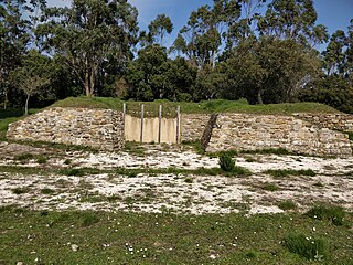
The Fort of Mosqueiro, also known as the Redoubt of Mosqueiro, is one of a group of fortifications in Portugal that made up the Lines of Torres Vedras, which were designed to protect the capital, Lisbon, from possible invasion by French troops during the Peninsular War. It is situated near Bucelas in the Loures municipality in the Lisbon District of Portugal.
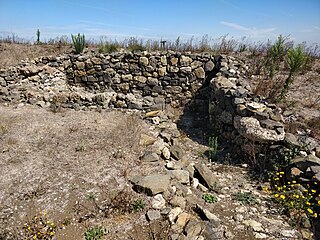
The Fort of Ribas, also known as the Redoubt of Ribas and the Redoubt of Freixial Alto, is one of a group of fortifications in Portugal that made up the second of the three defensive Lines of Torres Vedras, between the Atlantic Ocean and the River Tagus, which were designed to protect the capital, Lisbon, from possible invasion by French troops during the Peninsular War. It was designed for a garrison of 300 soldiers, with three or four cannon. The fort is situated near the town of Bucelas in the Lisbon District of Portugal.

The Fort of São Vicente is located in the town and municipality of Torres Vedras, in the Lisbon District of Portugal. In 1809 it was the first of 152 forts, redoubts and other defences to be developed as part of three defensive lines between the Atlantic Ocean and the River Tagus that were designed by the Duke of Wellington to protect the Portuguese capital, Lisbon, from possible invasion by French troops during the Peninsular War. These came to be known as the Lines of Torres Vedras. Together with the Fort of Alqueidão, it is considered the most important fortress of those constructed for the Lines.
The Fort of São João das Maias, also known as the Fort of Oeiras, is located on the right bank of the River Tagus estuary, in the municipality of Oeiras in the Lisbon District of Portugal. It was constructed between 1644 and 1653. Until 2010 it had been allowed to fall into a state of advanced degradation but in that year it was restored.

The Fort of Casa was the most easterly of the forts and redoubts built in 1809-10 during the Peninsular War on the second line of the three defensive Lines of Torres Vedras aimed at protecting the capital of Portugal, Lisbon. It is situated in the town of Forte da Casa, in the municipality of Vila Franca de Xira, in the Lisbon District.

The Forts of Serra da Aguieira were three forts constructed within 100 metres of each other as part of the second line of defence of the so-called Lines of Torres Vedras, which were constructed by Anglo-Portuguese forces in 1810 in order to protect the Portuguese capital Lisbon from possible invasion by the French during the Peninsular War. The forts are situated in the municipality of Vila Franca de Xira, in the Lisbon District of Portugal. From north to south the three forts are the Fort of Aguieira, the Fort of Portela Grande, and the Fort of Portela Pequena.

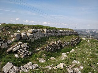
The Fort of Arpim is in the parish of Bucelas in the municipality of Loures, in the Lisbon District of Portugal. It was constructed during the Peninsular War, forming part of the first of three defensive Lines of Torres Vedras aimed at protecting Lisbon, the capital of Portugal, from French invasion. The fort, which never saw battle, has been restored and can be visited.

The Redoubt of Mount Cintra, commonly known as the Fort of Sacavém, is located in the town of Sacavém in the municipality of Loures in the Lisbon District of Portugal. It is situated immediately to the north of Lisbon. The fort’s construction began in 1875 and was completed in 1892. Since 2015 it has served as the National Archive for Portugal’s Directorate General of Cultural Heritage (DGPC).

The Fort of Alqueidão, also known as Forte Grande, is located about 2 kilometres south of the parish of Sobral de Monte Agraço, in the municipality of Sobral de Monte Agraço, in the Lisbon District of Portugal. It was one of the first and one of the largest of 152 military works known as the Lines of Torres Vedras that were built in 1809-10 to defend Lisbon during the Peninsular War (1807–14). The fort played a major role in stopping the advance of Napoleonic troops.

The Forts of Ajuda are located in the parish of Bucelas, in the municipality of Loures in the Lisbon District of Portugal. Just a short distance apart, the Forts of Ajuda Grande (Big) and Ajuda Pequeno (Small) were built in 1810 as part of the Lines of Torres Vedras, which were defensive lines to protect the Portuguese capital Lisbon from invasion by the French during the Peninsular War (1807–14).
The Fort of Carvalha is located in the parish of São Tiago dos Velhos, at the highest point of the municipality of Arruda dos Vinhos, in the Lisbon District of Portugal. It was built in 1809-10 as part of the first of the three Lines of Torres Vedras, which were defensive lines to protect the Portuguese capital Lisbon from invasion by the French during the Peninsular War (1807–14) or, in the event of defeat, to safely embark a retreating British Army.

The Fort of Feiteira is located in the municipality of Torres Vedras, in the Lisbon District of Portugal. Construction of the fort began in 1810 as part of the first of the three Lines of Torres Vedras, which were defensive lines to protect the Portuguese capital Lisbon from invasion by the French during the Peninsular War (1807–14) or, in the event of defeat, to protect the embarkation of a retreating British Army.

The Fort of Archeira is located in the municipality of Torres Vedras, in the Lisbon District of Portugal. It is also today known as the Furadouro Redoubt and was called the “Cheira” at the time of construction. Construction began in 1810 as part of the first of the three Lines of Torres Vedras, which were defensive lines to protect the Portuguese capital Lisbon from invasion by the French during the Peninsular War (1807–14) or, in the event of defeat, to protect the embarkation of a retreating British Army.

The Fort of Monsanto, also known as the Marquês de Sá da Bandeira Fort, is located at the top of the Monsanto hill in the Monsanto Forest Park, in Lisbon, Portugal. Built at the end of the 19th century as part of Lisbon's Campo Entrincheirado defensive ring around the city, the fort is now a maximum-security prison.

