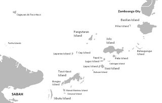
The Sulu Archipelago is a chain of islands in the Pacific Ocean, in the southwestern Philippines. The archipelago forms the northern limit of the Celebes Sea and southern limit of the Sulu Sea. The Sulu Archipelago islands are within the Mindanao island group, consisting of the provinces of Basilan, Sulu, and Tawi-Tawi; hence the archipelago is sometimes referred to as Basulta, derived from the first syllables of the three provinces.

Aranjuez is a city and municipality of Spain, part of the Community of Madrid.

The Retiro Park, also known as Buen Retiro Park or simply El Retiro, is one of the largest city parks in Madrid, Spain. The park belonged to the Spanish monarchy until 1868, when it became a public park following the Glorious Revolution.

Ronda is a municipality of Spain belonging to the province of Málaga, within the autonomous community of Andalusia.

The Royal Palace of Madrid is the official residence of the Spanish royal family at the city of Madrid, although now used only for state ceremonies. The palace has 135,000 m2 (1,450,000 sq ft) of floor space and contains 3,418 rooms. It is the largest royal palace in Europe.

Villena is a city in Spain, in the Valencian Community. It is located at the northwest part of Alicante, and borders to the west with Castilla-La Mancha and Murcia, to the north with the province of Valencia and to the east and south with the province of Alicante. It is the capital of the comarca of the Alto Vinalopó. The municipality has an area of 345.6 km² and a population of 34,144 inhabitants as of INE 2023.

Moros y Cristianos or Moros i Cristians, literally in English Moors and Christians, is a set of festival activities which are celebrated in many towns and cities of Spain, mainly in the southern Valencian Community. According to popular tradition the festivals commemorate the battles, combats and fights between Moors and Christians during the period known as Reconquista. There are also festivals of Moros y Cristianos in Spanish America.

Spain is a Christian majority country, with Islam being a minority religion, practised mostly by immigrants from Muslim majority countries, and their descendants.
Emilio García Gómez, 1st Count of Alixares was a Spanish Arabist, literary historian and critic, whose talent as a poet enriched his many translations from Arabic.

Moros is a municipality in the province of Zaragoza, Aragon. Its population was 304 in 2021.
Torrijo del Campo is a municipality located in the province of Teruel, Aragon, Spain. According to the 2018 census (INE), the municipality has a population of 447 inhabitants.

El Espinar is a Spanish town council located 65 kilometres away from Madrid city centre, in the northern slope of the Sistema Central mountain range. It belongs to the province of Segovia and to the autonomous Community of Castile and León.

The Parque del Oeste is a park of the city of Madrid (Spain) situated between the Autovía A-6, the Ciudad Universitaria de Madrid and the district of Moncloa. Before the 20th century, the land that the park currently occupies was the main landfill of the city. The park is the initiative of Alberto Aguilera, the mayor of the city at the beginning of the 20th century, who in 1906 requested the layout of a place for walking and relaxation by landscape artist Celedonio Rodrígáñez. It has beautiful sites such as the rose garden, where a rose competition is held every year.

The Palace of Infante don Luis is a neoclassic style palace located in Boadilla del Monte, Community of Madrid, Spain built between 1763 and 1765. It was declared Bien de Interés Cultural in 1974.

Enrique María Repullés, was a Spanish architect.

La Tauromaquia (Bullfighting) is a series of 33 prints created by the Spanish painter and printmaker Francisco Goya, which was published in 1816. The works of the series depict bullfighting scenes. There are also seven extra prints that were not published in the original edition.

The Walls of Felipe IV surrounded the city of Madrid between 1625 and 1868. Philip IV ordered their construction to replace the earlier Walls of Philip II and the Walls del Arrabal, which had already been surpassed by the growth of population of Madrid. These were not defensive walls, but essentially served fiscal and surveillance purposes: to control the access of goods to the city, ensure the collection of taxes, and to monitor who went in and out of Madrid. The materials used for construction were brick, mortar and compacted earth.

The Walls of Madrid are the five successive sets of walls that surrounded the city of Madrid from the Middle Ages until the end of the 19th century. Some of the walls had a defensive or military function, while others made it easy to tax goods entering the city. Towards the end of the 19th century the demographic explosion that came with the Industrial Revolution prompted urban expansion throughout Spain. Older walls were torn down to enable the expansion of the city under the grid plan of Carlos María de Castro.
The Walls del Arrabal were the third in a set of five walls built around Madrid, now the capital of Spain. There are no remaining ruins of the Walls del Arrabal, leaving some debate as to their extent and the period of their construction. It is possible that the walls were built as early as the 12th century, however they were most likely constructed in 1438. The walls may have been intended to protect people against the plagues that ravaged the city at the time. The walls united the urbanized suburbs of the city and prevented entry of the infected.

The Royal Collections Gallery, originally named the Royal Collections Museum, is an art museum in Madrid. Run by the Spanish state agency Patrimonio Nacional, it is located in a new building above the gardens of the Campo del Moro park and next to the Almudena Cathedral and the Royal Palace.


