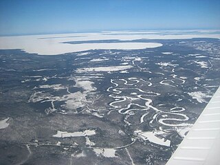
Victoria Island is a large island in the Arctic Archipelago that straddles the boundary between Nunavut and the Northwest Territories of Canada. It is the eighth-largest island in the world, and at 217,291 km2 (83,897 sq mi)1 in area, it is Canada's second-largest island. It is nearly double the size of Newfoundland (111,390 km2 [43,010 sq mi]), and is slightly larger than the island of Great Britain (209,331 km2 [80,823 sq mi]) but smaller than Honshu (225,800 km2 [87,200 sq mi]). The western third of the island lies in the Inuvik Region of the Northwest Territories; the remainder is part of Nunavut's Kitikmeot Region. The population of 2,168 is divided between two settlements, the larger of which is Cambridge Bay (Nunavut) and the other Ulukhaktok.

Tome-Adelino is a former census-designated place (CDP) in Valencia County, New Mexico, United States. The population was 2,211 at the 2000 census. It is part of the Albuquerque Metropolitan Statistical Area. For the 2010 census, the CDP was split into the census-designated places of Tome and Adelino.

Unorganized North Algoma District is an unorganized area in northeastern Ontario, Canada, comprising all areas in Algoma District, north of the Sault Ste. Marie to Elliot Lake corridor, which are not part of an incorporated municipality or a First Nation. It covers 44,077.03 km2 (17,018.24 sq mi) of land, and had a population of 6050 in 2021. Many of these communities were/are stations on the Algoma Central Railway or were logging/mining towns.
Cape Greig is a geographical feature of the Alaska Peninsula in the U.S. state of Alaska, where a 290-foot ridge juts into the Bering Sea. It is located on the Bristol Bay coast eight miles north of Smoky Point and 32 miles south of Goose Point.
The Izavieknik River is a 22-mile-long (35 km) river in the U.S. state of Alaska. It flows southwest through Upper Togiak Lake to Togiak Lake, 85 miles (137 km) northeast of Goodnews Bay. The entire river lies within the Togiak Wilderness portion of Togiak National Wildlife Refuge.

The Great Northern Peninsula is the largest and longest peninsula of Newfoundland, Canada, approximately 270 km long and 90 km wide at its widest point and encompassing an area of 17,483 km2. It is defined as that part of Newfoundland from Bonne Bay northwards around Cape Norman and Cape Bauld and thence southwards to the head of White Bay, bounded by the Gulf of St. Lawrence on the west, the Strait of Belle Isle on the north and the Labrador Sea and White Bay on the east.

Washington Township is one of the eleven townships of Lucas County, Ohio, United States. The 2020 census found 3,055 people in the township.

Guia Lopes da Laguna is a municipality located in the Brazilian state of Mato Grosso do Sul. Its population was 9,824 (2020) and its area is 1,210 km².

Battledykes is a Roman camp slightly to the north of Forfar, Scotland. According to Hector Boece, Pictish chiefs met at a castle by Forfar Loch to plan how to repel the Roman armies, who invaded several times between the 1st and 4th centuries AD. Eventually, the better equipped Romans prevailed, later to be displaced again by the Picts. The Romans established a Roman Camp at Battledykes, approximately three miles north of Forfar; this camp was assessed to have held 50,000 to 60,000 men. From Battledykes northward the Romans established a succession of camps including Stracathro, Raedykes and Normandykes.
Hügelland/Täler is a Verwaltungsgemeinschaft in the district Saale-Holzland, in Thuringia, Germany. The seat of the Verwaltungsgemeinschaft is in Tröbnitz.
Kremlin is an unincorporated community in Westmoreland County, Virginia.
East Green Harbour is a community of the Municipality of the District of Shelburne in the Canadian province of Nova Scotia.
Spruce Bay is a hamlet in the Canadian province of Saskatchewan. It is located on the north-western shore of Meeting Lake, adjacent to Meeting Lake Regional Park.

Clove Lakes Park is a public park in the Sunnyside neighborhood of Staten Island in New York City.
Vermilion Bay is a bay in southern Louisiana in the United States.
Mount Lolo, 218m is a summit in Sayward Land District on the west side of Quadra Island, British Columbia, Canada, overlooking Seymour Narrows.
The Mennaye Field is a sports stadium located in Penzance, Cornwall, UK. The ground was provided by the Borough of Penzance for the Penzance and Newlyn RFC formed on Tuesday, 12 December 1944 with the amalgamation of Penzance RFC and Newlyn RFC. The current tenants are the Cornish Pirates rugby union team, who play in the RFU Championship. The club moved, in 2005, to a temporary stadium at Kenwyn, near Truro and the following year to Camborne Recreation Ground. In 2010 the club returned to the Mennaye Field and announced that the capacity would be increased from its original capacity of 3,500 to the current capacity of 4,000 with 2,200 seats.

The English River Dene Nation is a Dene First Nation band government in Patuanak, Saskatchewan, Canada. Their reserve is in the northern section of the province. Its territories are in the boreal forest of the Canadian Shield. This First Nation is a member of the Meadow Lake Tribal Council (MLTC).
Manuel Garcia II is a census-designated place (CDP) in Starr County, Texas, United States. It is a new CDP, formed from part of the former La Casita-Garciasville CDP prior to the 2010 census, with a population of 77.


