Related Research Articles
Aviron Bay is natural bay on the island of Newfoundland in the province of Newfoundland and Labrador, Canada. The Friar, a castellated rock, is located between Aviron Bay and Cul-de-sac bay.
Facheux Bay was the location of a small fishing settlement of the same name. In 1901 it had a population of 47. The community was also called Fachier, Facheaux, and Fouche. Facheux Bay is a deep fjord that separates Eastern Head and Western Head of Hermitage Bay, Newfoundland, Canada. Facheux bay is 2.25 miles (3.62 km) west of Mosquito Cove. The entrance is between two steep falls in high hills. The bay runs in 6.5 miles (10.5 km), with an average width of 0.75 miles (1.21 km), and has deep water throughout. On the west side are three coves with anchorage in 20 to 10 fathoms.
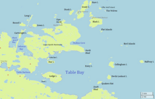
Table Bay is a natural bay and former community on the coast of Labrador in the province of Newfoundland and Labrador, Canada. It drains into the Labrador Sea to the east.
Dragon Bay is a natural bay in Newfoundland, Canada. Indrafts include Mooring Cove, Willis Cove, Tickle Cove, and Crew Cove. Dragon bay runs in a westerly direction for more than 3 miles (4.8 km) from the entrance to Facheux Bay. It is narrow and deep throughout, with no anchorage. The south point of the entrance to this bay is Red Rock, the north point is Gray Rock, which has a cave. Little Hole lies 0.75 miles (1.21 km) west of Dragon Bay, and has shelter for small vessels.

La Poile Bay is a natural bay in Newfoundland, Canada, in the southwestern area of the island, off the south coast. It subdivides into Northeast Arm and North Bay. The settlement of La Poile is located on the bay.

Mortier Bay is a natural bay on the Burin Peninsula on the south coast of the island of Newfoundland in the province of Newfoundland and Labrador, Canada. It is entered through a channel 1.5 miles (2.4 km) long and 0.5 miles (0.80 km)wide, at the north end of which the bay opens nearly 2 miles (3.2 km) in diameter with deep water and no anchorage, except in the harbors off it. The settlement of Marystown is located on the bay.
Diable Bay is a small, open bay on the island of Newfoundland in the province of Newfoundland and Labrador, Canada. The settlement of L'Anse-au-Diable was close by.
Devil Bay is natural bay on the island of Newfoundland in the province of Newfoundland and Labrador, Canada. Its features include waterfalls and a steep bluff. It is near Hare Bay and Rencontre Bay.
Rencontre Bay is natural bay on the island of Newfoundland in the province of Newfoundland and Labrador, Canada. It is near Devil Bay.
Chaleur Bay is natural bay on the island of Newfoundland in the province of Newfoundland and Labrador, Canada. Its features include cliffs, ravines and waterfalls.
François Bay is natural bay on the island of Newfoundland in the province of Newfoundland and Labrador, Canada. It is near Chaleur Bay. The settlement of Francois is located on the bay.
La Hune Bay is natural bay on the island of Newfoundland in the province of Newfoundland and Labrador, Canada. It is by Cape La Hune.
Woody Bay is a natural bay on the island of Newfoundland in the province of Newfoundland and Labrador, Canada. Located 0.5 miles (0.80 km) from Little Port, Woody Bay is about two cables in diameter, and fit for boats only, that have considerable difficulty in entering with westerly winds.

Well Bay is a natural bay near St. John Harbor, off the island of Newfoundland in the province of Newfoundland and Labrador, Canada. It is located on the southern part of St. John Harbor, in a bay called Good Bay. Well Bay is a natural indentation in the northern part of Good Bay. The middle of Well Bay has depths of 9.1–10.9 m. About 0.5 mile northeast of Well Bay, there are two beacons.
St. Margaret Bay is a natural bay off the island of Newfoundland in the province of Newfoundland and Labrador, Canada. It is located on the northwest coast of Newfoundland's Great Northern Peninsula.
Ste. Genevieve Bay is a natural bay off the island of Newfoundland in the province of Newfoundland and Labrador, Canada.
Hopeall Bay is a natural bay off the island of Newfoundland in the province of Newfoundland and Labrador, Canada. It is an arm of Trinity Bay, which in turn opens to the Atlantic Ocean.
Scrammy Bay is a natural bay on the coast of Labrador in the province of Newfoundland and Labrador, Canada. It is in the southeast reaches of St. Mary’s Bay to the east of lavander’s Arm.
Blackguard Bay is a natural bay on the coast of Labrador in the province of Newfoundland and Labrador, Canada. The closest inhabited place is Cartwright.
Pensons Arm is a local service district and designated place in the Canadian province of Newfoundland and Labrador. Pensons Arm, is a coastal village in Labrador, 20 km southeast of Charlottetown. It has a population of 43 in the 2021 census.
References
- This article includes text incorporated from United States Hydrographic Office & R. G. Davenport's "Newfoundland and Labrador: The coast and banks of Newfoundland and the coast of Labrador, from Grand Point to the Koksoak River, with the adjacent islands and banks" (1884), a publication now in the public domain.
- ↑ United States Hydrographic Office; Davenport, Richard G. (1884). Newfoundland and Labrador: The coast and banks of Newfoundland and the coast of Labrador, from Grand Point to the Koksoak River, with the adjacent islands and banks (Public domain ed.). Govt. print. off. pp. 272–. Retrieved 13 November 2011.
50°48′00″N56°08′53″W / 50.800°N 56.148°W
| | This Newfoundland and Labrador location article is a stub. You can help Wikipedia by expanding it. |