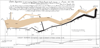
Cartography is the study and practice of making and using maps. Combining science, aesthetics and technique, cartography builds on the premise that reality can be modeled in ways that communicate spatial information effectively.

The Canadian Mathematical Society is an association of professional mathematicians dedicated to the interests of mathematical research, outreach, scholarship and education in Canada. It serves the national community through the publication of academic journals, community bulletins, and the administration of mathematical competitions.

Waldo Rudolph Tobler was an American-Swiss geographer and cartographer. Tobler is regarded as one of the most influential geographers and cartographers of the late 20th century and early 21st century. He is most well known for coining what has come to be referred to as Tobler's first law of geography. He also coined what has come to be referred to as Tobler's second law of geography.
Geovisualization or geovisualisation, also known as cartographic visualization, refers to a set of tools and techniques supporting the analysis of geospatial data through the use of interactive visualization.
The Canadian Federation for the Humanities and Social Sciences, also known as the Federation for the Humanities and Social Sciences, is a member-based organization and the national voice for researchers in the humanities and social sciences in Canada. Formed in 1996 through a merger of the Social Science Federation of Canada and the Canadian Federation for the Humanities, it is a non-profit charitable organization that represents more than 85,000 researchers in 81 scholarly associations, 80 universities and colleges, and 6 affiliates across the country.
Canadian Association of Physicists (CAP), or in French Association canadienne des physiciens et physiciennes (ACP) is a Canadian professional society that focuses on creating awareness among Canadians and Canadian legislators of physics issues, sponsoring physics related events, physics outreach, and publishes Physics in Canada. It was founded in July 1945. The organization has over 1,600 members and is bilingual, functioning in English and French.

A thematic map is a type of map that portrays the geographic pattern of a particular subject matter (theme) in a geographic area. This usually involves the use of map symbols to visualize selected properties of geographic features that are not naturally visible, such as temperature, language, or population. In this, they contrast with general reference maps, which focus on the location of a diverse set of physical features, such as rivers, roads, and buildings. Alternative names have been suggested for this class, such as special-subject or special-purpose maps, statistical maps, or distribution maps, but these have generally fallen out of common usage. Thematic mapping is closely allied with the field of Geovisualization.
Mark Stephen Monmonier is a Distinguished Professor of Geography and the Environment at the Maxwell School of Citizenship and Public Affairs of Syracuse University. He specializes in geography, geographic information systems, toponymy, and the history of cartography.

The International Cartographic Association (ICA) is an organization formed of national member organizations, to provide a forum for issues and techniques in cartography and geographic information science (GIScience). ICA was founded on June 9, 1959, in Bern, Switzerland. The first General Assembly was held in Paris in 1961. The mission of the International Cartographic Association is to promote the disciplines and professions of cartography and GIScience in an international context. To achieve these aims, the ICA works with national and international governmental and commercial bodies, and with other international scientific societies.

The Association for Slavic, East European, and Eurasian Studies (ASEEES) is a scholarly society "dedicated to advancing knowledge about Central Asia, the Caucasus, Russia, and Eastern Europe in regional and global contexts." The ASEEES supports teaching, research, and publication relating to the peoples and territories within this area.

The British Cartographic Society (BCS) is an association of individuals and organisations dedicated to exploring and developing the world of maps. It is a registered charity. Membership includes national mapping agencies, publishers, designers, academics, researchers, map curators, individual cartographers, GIS specialists and ordinary members of the public with an interest in maps.
The Australasian Association of Philosophy (AAP) is the peak body for philosophy in Australasia. The chief purpose of the AAP is to promote philosophy in Australia, New Zealand, and Singapore. Among the means that it follows to achieve this end, the AAP runs an annual conference, publishes two journals, awards various prizes, sponsors postgraduate and undergraduate philosophical activities, maintains affiliations with numerous other organisations that aim to promote philosophy and philosophical activity, and promotes philosophy in schools, cafes, pubs, and everywhere else that philosophy may be found.
Alan M. MacEachren is an American geographer, Professor of Geography and Director, GeoVISTA Center, Department of Geography, The Pennsylvania State University. He is known for his cross-disciplinary work in the fields of human-centered geographic visualization, scientific and information visualization, and in statistics.
Mass media influences spatial perception through journalistic cartography and spatial bias in news coverage.

The Canadian Cat Association is a non-profit organization in Canada whose mission is to promote the welfare of all cats in Canada, maintain a registry of pedigreed cats in Canada, and further the improvement of all breeds of cats in Canada. CCA-AFC is Canada's only globally-recognized national cat registry, with its pedigrees and registrations accepted by major global associations such as the Cat Fanciers' Association, The International Cat Association, and Fédération Internationale Féline. To date, CCA-AFC has registered over 190,000 cats.
The Canadian Communication Association is a national, bilingual association of communications researchers, educators, and private and public sector professionals in Canada. Established in 1979, the CCA/ACC "seeks to advance communication research and studies in the belief that a better understanding of communication is crucial to building a vibrant society."
D. R. Fraser Taylor, is Chancellor's Distinguished Research Professor of International Affairs Geography and Environmental Studies at Carleton University, Canada and a Fellow of the Royal Society of Canada. Taylor studies applications of cartography to development, including international development. He is best known for his work on Cybercartography.
Brandon S. Plewe is a geographer and Associate Professor of geography at Brigham Young University.
George Frederick Jenks (1916–1996) was an American geographer known for his significant contributions to cartography and geographic information systems (GIS). With a career spanning over three decades, Jenks played a vital role in advancing map-making technologies, was instrumental in enhancing the visualization of spatial data, and played foundational roles in developing modern cartographic curricula. The Jenks natural breaks optimization, based on his work, is still widely used in the creation of thematic maps, such as choropleth maps.
Technological Transition in Cartography is a seminal book by Mark Monmonier, first published in 1985. The book explores the impact of technological advancements on the evolution of the field of cartography, examining how innovations in technology have transformed the methods and practices of mapmaking. The book was created to target cartography students of the time, and sought to demonstrate the importance of viewing cartography as a method of delivering geographic information, rather than using the technology.


