Related Research Articles

Remote sensing is the acquisition of information about an object or phenomenon without making physical contact with the object, in contrast to in situ or on-site observation. The term is applied especially to acquiring information about Earth and other planets. Remote sensing is used in numerous fields, including geophysics, geography, land surveying and most Earth science disciplines. It also has military, intelligence, commercial, economic, planning, and humanitarian applications, among others.
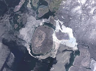
Prince Charles Island is a large, low-lying island in Canada. With an area of 9,521 km2 (3,676 sq mi), it is the world's 77th largest island and the 19th largest island in Canada. It is located in Foxe Basin, off the west coast of Baffin Island, in the Qikiqtaaluk Region of Nunavut, Canada. Though Prince Charles Island has no permanent residents, Inuit visited the island to hunt caribou; the island has no specific name in the Inuktitut language. Despite the island's size, it was not recorded by Western cartographers until 1932, when the tug captain W. A. Poole first sighted it. His information never made it onto any published map. Although, it was rediscovered in 1948 by Albert-Ernest Tomkinson navigating an Avro Lancaster for the RCAF 408 (Photo) Squadron. The island was named for British Prince Charles, who was born in November the same year.
Lawrence Whitaker Morley was a Canadian geophysicist and remote sensing pioneer. He was best known for his studies on the magnetic properties of the oceanic crust and their effect on plate tectonics and for starting the remote sensing program in Canada.
Pisharoth Rama Pisharoty was an Indian physicist and meteorologist, and is considered to be the father of remote sensing in India.
The American Society for Photogrammetry and Remote Sensing (ASPRS) is an American learned society devoted to photogrammetry and remote sensing. It is the United States' member organization of the International Society for Photogrammetry and Remote Sensing. Founded in 1934 as American Society of Photogrammetry and renamed in 1985, the ASPRS is a scientific association serving over 7,000 professional members around the world. As a professional body with oversight of specialists in the arts of imagery exploitation and photographic cartography. Its official journal is Photogrammetric Engineering & Remote Sensing (PE&RS), known as Photogrammetric Engineering between 1937 and 1975.

Hemispherical photography, also known as canopy photography, is a technique to estimate solar radiation and characterize plant canopy geometry using photographs taken looking upward through an extreme wide-angle lens or a fisheye lens. Typically, the viewing angle approaches or equals 180-degrees, such that all sky directions are simultaneously visible. The resulting photographs record the geometry of visible sky, or conversely the geometry of sky obstruction by plant canopies or other near-ground features. This geometry can be measured precisely and used to calculate solar radiation transmitted through plant canopies, as well as to estimate aspects of canopy structure such as leaf area index. Detailed treatments of field and analytical methodology have been provided by Paul Rich and Robert Pearcy (1989).
IMS-1 is an Earth observation satellite in a Sun-synchronous orbit. The satellite which is the fourteenth satellite in the Indian Remote Sensing (IRS) satellite series has been built, launched and maintained by the Indian Space Research Organisation (ISRO). IMS-1 is the first satellite to use ISRO's Indian Mini Satellite bus.
The International Society for Photogrammetry and Remote Sensing (ISPRS) is an international non-governmental organization that enhances international cooperation between the worldwide organizations with interests in the photogrammetry, remote sensing and spatial information sciences. Originally named International Society for Photogrammetry (ISP), it was established in 1910, and is the oldest international umbrella organization in its field, which may be summarized as addressing “information from imagery”.

George Joseph is an Indian space scientist, best known for his contributions to the development of remote sensing technology in India, especially in the field of Earth observation sensors. He is a former chairman of the Lunar Mission Study Task Force of the Indian Space Research Organization and an elected fellow of the National Academy of Sciences, India, Indian Academy of Sciences and Indian National Academy of Engineering. The Government of India awarded him the Padma Bhushan, the third highest civilian award, in 1999.
Aluru Seelin Kiran Kumar is an Indian space scientist and former chairman of the Indian Space Research Organisation, having assumed office on 14 January 2015. He is credited with the development of key scientific instruments aboard the Chandrayaan-1 and Mangalyaan space crafts. In 2014, he was awarded the Padma Shri, India's fourth highest civilian award, for his contributions to the fields of science and technology. Kiran Kumar previously served as Director of Ahmedabad Space Applications Centre.

Bulusu Lakshmana Deekshatulu is an Indian academic who has made important contributions to Digital Image Processing and Control Theory. He is a Fellow of The World Academy of Sciences, Fellow of Indian National Science Academy, The National Academy of Sciences, India, Indian Academy of Sciences, Indian National Academy of Engineering, National Academy of Agricultural Sciences, and IEEE.
Dasika Durga Prasada Rao is an Indian geoscientist and the former director of the National Remote Sensing Agency. Born in 1939 to a family of Guntur-Vijayawada region. He is a 1998 Fellow of the National Academy of Sciences, India. Rao was honored by the Government of India, in 2001, with the fourth highest Indian civilian award of Padma Shri. Two years later, he received the Bhaskara Award from the Indian Society of Remote Sensing in 2003.
The Canada Centre for Mapping and Earth Observation (CCMEO) (formerly Canada Centre for Remote Sensing (CCRS)) is a branch of Natural Resources Canada's Earth Science Sector. It was created in 1970 with Lawrence Morley as the first Director General. The department also works closely with the private sector, especially with the development of GIS software.
Elizabeth Pattey is a principal research scientist at Agriculture and Agri-Food Canada (AAFC) and the leader of the micrometeorology laboratory at the Ottawa Research and Development Centre. Her research supports nationwide improvement in the environmental performance of agriculture, in support of the United Nations' Framework Convention on Climate Change and Canada’s Clean Air Act. She is the co-author for over 80 peer-reviewed scientific publications, and her areas of expertise include trace gas flux measurement techniques, process-based models, and remote-sensing applications.

SPRITE was a proposed Saturn atmospheric probe mission concept of the NASA. SPRITE is a design for an atmospheric entry probe that would travel to Saturn from Earth on its own cruise stage, then enter the atmosphere of Saturn, and descend taking measurements in situ.
Trevor Charles Platt was a British and Canadian biological oceanographer who was distinguished for his fundamental contributions to quantifying primary production by phytoplankton at various scales of space and time in the ocean.

Avik Bhattacharya is a professor at the Centre of Studies in Resources Engineering, Indian Institute of Technology Bombay, Mumbai, India. He has been working in the field of radar polarimetry theory and applications for more than a decade. His main focuses on the use of synthetic aperture radar (SAR) data for land use classification, change detection and qualitative and quantitative biophysical and geophysical information estimation.
The Remote Sensing and Photogrammetry Society (RSPSoc) is a British learned society devoted to photogrammetry and remote sensing. It is the UK's adhering body of the International Society for Photogrammetry and Remote Sensing.
The Canadian Journal of Remote Sensing is an academic journal about remote sensing published by Taylor & Francis on behalf of the Canadian Remote Sensing Society and the Canadian Aeronautics and Space Institute. Its editor-in-chief is Monique Bernier; its 2020 impact factor is 2.000.
Nicholas Charles Coops is an Australian-Canadian researcher. He is a Tier 1 Canada Research Chair in Remote Sensing at the University of British Columbia's Department of Forest Resources Management. In 2020, Coops received the Marcus Wallenberg Prize in recognition of his work in with satellite imagery in order to make predictions about forest growth and the ability of forests to store carbon.
References
| | This article about an organization in Canada is a stub. You can help Wikipedia by expanding it. |