
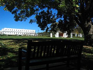
Canberra is the capital city of Australia. Founded following the federation of the colonies of Australia as the seat of government for the new nation, it is Australia's largest inland city and the eighth-largest Australian city overall. The city is located at the northern end of the Australian Capital Territory at the northern tip of the Australian Alps, the country's highest mountain range. As of June 2023, Canberra's estimated population was 466,566.

Namadgi National Park is a protected area in the south-west of the Australian Capital Territory (ACT), bordering Kosciuszko National Park in New South Wales. It lies approximately 40 kilometres (25 mi) southwest of Canberra, and occupies approximately 46 percent of the ACT's land area.
Tidbinbilla Nature Reserve is a 54.5 square kilometres (21.0 sq mi) protected area, on the fringe of Namadgi National Park. Tidbinbilla is a short drive from the capital city of Australia, Canberra, in the Australian Capital Territory.

The University of Canberra (UC) is a public research university with its main campus located in Bruce, Canberra, Australian Capital Territory. The campus is 2.5 km (1.6 mi) from Belconnen Town Centre, and 8.7 km (5.4 mi) from Canberra's Civic Centre. UC offers undergraduate and postgraduate courses covering five faculties: Health; Arts and Design; Business, Government and Law; Education; and Science and Technology.

Yarralumla is a large inner south suburb of Canberra, the capital city of Australia. Located approximately 3.5 km (2.2 mi) south-west of the city, Yarralumla extends along the south-west bank of Lake Burley Griffin from Scrivener Dam to Commonwealth Avenue.

The Canberra Deep Space Communication Complex (CDSCC) is a satellite communication station, part of the Deep Space Network of NASA's Jet Propulsion Laboratory (JPL), located at Tidbinbilla in the Australian Capital Territory. Opened in 1965, the complex was used for tracking the Apollo Lunar Module, and along with its two sister stations at Goldstone, California and Madrid, Spain is now used for tracking and communicating with NASA's spacecraft, particularly interplanetary missions. Its DSS-43 antenna is the only antenna on Earth that can send commands to Voyager 2. It is managed in Australia by the Commonwealth Scientific and Industrial Research Organisation (CSIRO) for NASA’s Space Communications and Navigation program (SCaN) at NASA Headquarters in Washington, D.C.

Canberra Airport is an international airport situated in the district of Majura, Australian Capital Territory. It serves Australia's capital city, Canberra, as well as the nearby city of Queanbeyan and regional areas of the Australian Capital Territory and southeastern New South Wales. Located approximately 8 km (5.0 mi) from the city centre, within the North Canberra district, it is the ninth-busiest airport in Australia.

The Australian National Botanic Gardens (ANBG) is a heritage-listed botanical garden located in Acton, Canberra, in the Australian Capital Territory, Australia. Established in 1949, the Gardens is administered by the Australian Government's Department of Agriculture, Water and the Environment. The botanic gardens was added to the Commonwealth Heritage List on 22 June 2004.

Manuka Oval is a sporting venue in Canberra, the capital of Australia. It is located in Griffith, in the area of that suburb known as Manuka. Manuka Oval has a seating capacity of 13,550 people and an overall capacity of 16,000 people, although this is lower for some sports depending on the configuration used. The area on which the ground is situated has been used for sport since the early 20th century, but was only enclosed in 1929. It has since undergone several redevelopments, most recently beginning in 2011.
The National Rose Gardens are a heritage-listed rose gardens located in Parkes, a suburb of Canberra, in the Australian Capital Territory of Australia. The rose gardens were added to the Australian Commonwealth Heritage List on 22 June 2004.
Taylor is a suburb in Gungahlin, Canberra, Australia. Development of the suburb began in 2017. It is named after magazine publisher Florence Mary Taylor, who was editor of and writer for several Australian building industry journals including the influential Building magazine. The suburb is approximately 4 km from the Gungahlin Town Centre and 16 km from the centre of Canberra and bounded to the south by Horse Park Drive. One Tree Hill lies to the northwest on the border with New South Wales. The suburb is located in north Gungahlin adjacent to the suburbs of Moncrieff, Casey, Jacka and Ngunnawal.

Jacka is a suburb of Gungahlin, Canberra, the National Capital of Australia. The suburb was gazetted on 25 April 2001 and development began in 2013. It had some residents at the beginning of 2014. The suburb is named after Albert Jacka, the first Australian to be decorated with the Victoria Cross during the First World War, receiving the medal for his actions during the Gallipoli Campaign. Jacka is located in north Gungahlin adjacent to the suburbs of Amaroo, Taylor, Bonner and Moncrieff. The suburb is located approximately 4 km from the Gungahlin Town Centre and 16 km from the centre of Canberra.

Casey is a suburb in Canberra, Australia, approximately 4 km from the Gungahlin Town Centre and about 13 km from the centre of Canberra. The suburb is named after Richard Casey, Baron Casey an Australian politician, diplomat and later the 16th Governor-General of Australia. It is bound by Horse Park Drive and Clarrie Hermes Drive. Casey is located in north-west Gungahlin, adjacent to the suburbs of Nicholls and Ngunnawal, and the future suburbs of Taylor and Moncrieff.

Moncrieff is a suburb in the Gungahlin district of Canberra, the National Capital of Australia. The name was gazetted in April 1991, with initial land releases becoming available to developers in June 2014. It is named after Gladys Moncrieff, an Australian singer of the 1920-1930s musical era who was dubbed 'Australia's Queen of Song'. The suburb is in north Gungahlin, adjacent to the existing suburbs of Ngunnawal and Amaroo and the future suburbs of Taylor and Jacka. The suburb is located approximately 4 km from the Gungahlin Town Centre and 16 km from the centre of Canberra, and is bounded by Mirrabei Drive and Horse Park Drive. It is home to the Moncrieff Community Recreation Park, which was voted the ACT's favourite playground in 2021.
The National Folk Festival (NFF) is a longstanding, Australian family friendly celebration of all aspects of folk music and culture. It is held every year at Easter in the national capital, Canberra.

Ginninderra Creek, a partly perennial stream of the Murrumbidgee catchment within the Murray–Darling basin, is located in the Capital Country region spanning both the Australian Capital Territory and New South Wales, Australia.
McKellar Park, formerly known as Belconnen Soccer Centre and McKellar Soccer Centre, is an association football stadium in the Canberra suburb of McKellar, in Australia. The playing surface is rectangular in shape and is used almost exclusively for association football matches. The venue is the home ground of National Premier Leagues Capital Football club Belconnen United FC and W-League club Canberra United FC.

Canberra United Football Club is an Australian professional soccer club based in the southern Canberra suburb of Wanniassa, Australian Capital Territory. Founded in 2008 by Capital Football, the club was an inaugural member of the W-League and the only club not affiliated with an A-League Men team. Canberra United currently competes in the A-League Women, A-League Youth and NPLW leagues. Canberra's home stadium is McKellar Park and the club is a two-time champion and three-time premier of the W-League.
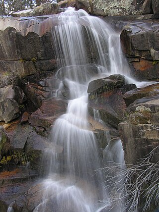
The Gibraltar Falls are a cascade waterfall on the Gibraltar Creek, in the Australian Capital Territory (ACT), approximately 50 kilometres from Canberra's city centre, The falls have a 50-metre (160-foot) drop.
Majura is a district in the Australian Capital Territory in Australia. With a population of 161 at the 2021 census, excluding the suburb of Pialligo, which lies to the south of Canberra Airport. Apart from Pialligo, Majura District includes Canberra Airport, three business parks and some farming but little residential development. The main shopping centre is the Majura Park Shopping Centre.
