Canby's Cross

Last updated
Canby's Cross

Canbys cross closeup.JPG

Reproduction of Canby's Cross located in Lava Beds National Monument. The writing on the cross reads, "Gen Canby USA was murdered here by the Modocs April 11, 1873"
Location Lava Beds National Monument
Coordinates 41°49′08″N121°32′37″W / 41.818767°N 121.543604°W / 41.818767; -121.543604 Coordinates: 41°49′08″N121°32′37″W / 41.818767°N 121.543604°W / 41.818767; -121.543604
Reference no. 110 [1]

Canby's Cross is located in Lava Beds National Monument, about 3 miles south of Tule Lake, and 5 miles south-southwest of the town of Tulelake, California. It was erected to commemorate General Canby's death at a peace gathering. General Canby was shot in the face by Captain Jack of the Modoc tribe, who was later hanged for the killing. The cross is registered as a California Historical Landmark. [1]

Lava Beds National Monument national monument in the United States

Lava Beds National Monument is located in northeastern California, in Siskiyou and Modoc counties. The monument lies on the northeastern flank of Medicine Lake Volcano and has the largest total area covered by a volcano in the Cascade Range.

Tule Lake intermittent lake in California

Tule Lake is an intermittent lake covering an area of 13,000 acres (53 km2), 8.0 km (5.0 mi) long and 4.8 km (3.0 mi) across, in northeastern Siskiyou County and northwestern Modoc County in California, along the border with Oregon.

Tulelake, California City in California

Tulelake is a city in Northeastern Siskiyou County, California, United States, at an elevation of 4,066 feet (1,239 m) above sea level. The town is named after nearby Tule Lake. The population was 1,010 at the 2010 census, down from 1,020 at the 2000 census. In an unusual circumstance, at least within California, Tulelake peace officers are authorized by state law, along with cooperation of the state of Oregon, to serve as and be recognized as peace officers within Malin, Oregon, along with the inverse being true for peace officers employed within Malin, wherein they are recognized as peace officers within Tulelake by the California Penal Code.

The cross reads: Gen Canby USA was murdered here by the Modocs April 11, 1873.

Edward Canby Union Army General

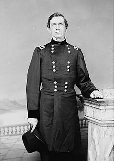
Edward Richard Sprigg Canby was a career United States Army officer and a Union general in the American Civil War.

Modoc people ethnic group

The Modoc are a Native American people who originally lived in the area which is now northeastern California and central Southern Oregon. They are currently divided between Oregon and Oklahoma and are enrolled in either of two federally recognized tribes, the Klamath Tribes in Oregon and the Modoc Tribe of Oklahoma.

The elevation of Canby's Cross is 4058 ft (1237 m). [2]

Canby's Cross, with stone foundation Canbys cross, lava beds national monument.JPG
Canby's Cross, with stone foundation

Related Research Articles

Modoc County, California County in California ----, United States

Modoc County is a county in the far northeast corner of the U.S. state of California. As of the 2010 census, the population was 9,686. making it the third-least populous county in California. The county seat and only incorporated city is Alturas. Previous county seats include Lake City and Centerville; the latter is now a ghost town. The county borders Nevada and Oregon.

Alturas, California City in California, United States

Alturas is a city in and the county seat of Modoc County, California. The population was 2,827 at the 2010 census.

Canby, Oregon City in Oregon, United States

Canby is a city in Clackamas County, Oregon, United States. The population was 15,829 at the 2010 census. It is along Oregon Route 99E, 2 miles (3 km) northeast of Barlow. In May 2016 Canby was featured on ABC's series 20/20, when the local "Canby Psychic" was part of an investigation of swindling a local rancher of $15 million.

Captain Jacks Stronghold

Captain Jack's Stronghold, named for Modoc chief Captain Jack, is a part of Lava Beds National Monument. The stronghold can be accessed from the Perez turnoff, off Highway 139 between Tulelake and Canby, California. The Modoc people had long used this area for hunting and gathering as it was part of their traditional territory.

Kintpuash chief of the Native American Modoc tribe

Kintpuash, also known as Captain Jack, was a chief of the Modoc tribe of California and Oregon. He led a band from the Klamath Reservation to return to their lands in California, where they resisted return. From 1872 to 1873, their small force made use of the lava beds, holding off more numerous United States Army forces for months in the Modoc War.

The Modoc War, or the Modoc Campaign, was an armed conflict between the Native American Modoc people and the United States Army in northeastern California and southeastern Oregon from 1872 to 1873. Eadweard Muybridge photographed the early part of the US Army's campaign.

First Battle of the Stronghold

The First Battle of the Stronghold was the second battle in the Modoc War of 1872–1873. The battle was fought between the United States Army under Lieutenant Colonel Frank Wheaton and a band of the Native American Modoc tribe from Oregon and California, led by Captain Jack.

Canby, California census-designated place in California, United States

Canby is a census-designated place in Modoc County, California. It is located 17 miles (27 km) west of Alturas, at an elevation of 4314 feet. It had a population of 315 at the 2010 census. The ZIP Code is 96015. The community is inside area code 530.

California State Route 139 highway in California

State Route 139 is a state highway in the U.S. state of California. Running from SR 36 in Susanville north to Oregon Route 39, it forms part of the shortest route between Reno, Nevada, and Klamath Falls, Oregon. SR 139 cuts through much Modoc National Forest and passes near Antelope Mountain and Tule Lake. North of SR 299, the highway was built by the federal government and turned over to the state in about 1940; the remainder was built by a joint highway district of Lassen and Modoc Counties, completed in 1956, and given to the state in 1959.

Fort Klamath park and former fort in Oregon, USA

Fort Klamath was a military outpost near the western end of the Oregon Trail, between Crater Lake National Park and Upper Klamath Lake in Klamath County, Oregon, United States. The Fort Klamath Site, about a mile southeast of the present community of Fort Klamath, Oregon, is listed on the U.S. National Register of Historic Places

Infernal Caverns

Infernal Caverns is the site of an 1867 battle between U.S. armed forces and Shoshone, Paiute, and Pit River Indians. Infernal Caverns Battleground is California Historical Landmark No. 16.

Astakiwi is a former Shastan settlement in Modoc County, California, United States. It was located in Warm Springs Valley near Canby; its precise location is unknown.

McArthur, Modoc County, California Unincorporated community in California, United States

McArthur is an unincorporated community in Modoc County, California. It is located on the Southern Pacific Railroad 11 miles (18 km) south of Alturas, at an elevation of 4373 feet.

Ghent is a former settlement in Modoc County, California. It was located on the Southern Pacific Railroad 2 miles (3.2 km) northwest of Canby.

Lillian is a former settlement in Modoc County, California. It was located 6 miles (9.7 km) southwest of Canby.

Cornell, Modoc County, California Unincorporated community in California, United States

Cornell is an unincorporated community in Modoc County, California. It is located on the Southern Pacific Railroad 6.5 miles (10 km) south-southeast of Newell, at an elevation of 4124 feet.

<i>Drum Beat</i> 1954 film by Delmer Daves

Drum Beat is a 1954 CinemaScope western film in WarnerColor written and directed by Delmer Daves and co-produced by Daves and Alan Ladd in his first film for his Jaguar Productions company. Ladd stars along with Audrey Dalton, Charles Bronson as Captain Jack, and Hayden Rorke as President Ulysses S. Grant.

References

  1. 1 2 "Canby's Cross". Office of Historic Preservation, California State Parks. Retrieved 2012-10-14.
  2. "Canby Cross". Geographic Names Information System . United States Geological Survey.