
Ravenna is the capital city of the Province of Ravenna, in the Emilia-Romagna region of Northern Italy. It was the capital city of the Western Roman Empire from 402 until the empire collapsed in 476. It then served as the capital of the Ostrogothic Kingdom until it was re-conquered in 540 by the Byzantine Empire. Afterwards, the city formed the centre of the Byzantine Exarchate of Ravenna until the last exarch was executed by the Lombards in 751. Although it is an inland city, Ravenna is connected to the Adriatic Sea by the Candiano Canal. It is known for its well-preserved late Roman and Byzantine architecture, with eight buildings comprising the UNESCO World Heritage Site "Early Christian Monuments of Ravenna".

Ancona is a city and a seaport in the Marche region in central Italy, with a population of around 101,997 as of 2015. Ancona is the capital of the province of Ancona and of the region. The city is located 280 km (170 mi) northeast of Rome, on the Adriatic Sea, between the slopes of the two extremities of the promontory of Monte Conero, Monte Astagno and Monte Guasco.

Adria is a town and comune in the province of Rovigo in the Veneto region of northern Italy, situated between the mouths of the rivers Adige and Po. The remains of the Etruscan city of Atria or Hatria are to be found below the modern city, three to four metres below the current level. Adria and Spina were the Etruscan ports and depots for Felsina. Adria may have given its name during an early period to the Adriatic Sea, to which it was connected by channels.

The Venetian Lagoon is an enclosed bay of the Adriatic Sea, in northern Italy, in which the city of Venice is situated. Its name in the Italian and Venetian languages, Laguna Veneta—cognate of Latin lacus, "lake"—has provided the English name for an enclosed, shallow embayment of salt water, a lagoon.

The Buckingham Canal is a 796 kilometres (494.6 mi) long fresh water navigation canal, that parallels the Coromandel Coast of South India from Kakinada City in the East Godavari district of Andhra Pradesh to Viluppuram District in Tamil Nadu. The canal connects most of the natural backwaters along the coast to Chennai (Madras) port.

The Caloosahatchee River is a river on the southwest Gulf Coast of Florida in the United States, approximately 67 miles (108 km) long. It drains rural areas on the northern edge of the Everglades, east of Fort Myers. An important link in the Okeechobee Waterway, a manmade inland waterway system of southern Florida, the river forms a tidal estuary along most of its course and has become the subject of efforts to restore and preserve the Everglades.

In physical geography, a channel is a type of landform consisting of the outline of a path of relatively shallow and narrow body of fluid, most commonly the confine of a river, river delta or strait. The word is cognate to canal, and sometimes takes this form, e.g. the Hood Canal.
The province of Forlì-Cesena is a province in the Emilia–Romagna region of Italy. Its capital is the city of Forlì. The province has a population of 394,273 as of 2016 over an area of 2,378.4 square kilometres (918.3 sq mi). It contains 30 comuni and the provincial president is Davide Drei. Although located close to the independent Republic of San Marino, Forlì-Cesena does not share a land border with the sovereign state.

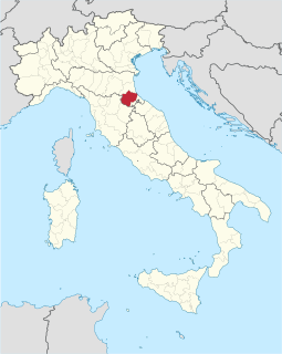
The province of Ravenna is a province in the Emilia-Romagna region of Italy. Its capital is the city of Ravenna. As of 2015, it has a population of 391,997 inhabitants over an area of 1,859.44 square kilometres (717.93 sq mi), giving it a population density of 210.81 inhabitants per square kilometre. Its provincial president is Claudio Casadio.

The Nakdong River or Nakdonggang is the longest river in South Korea, and passes through major cities such as Daegu and Busan. It takes its name from its role as the eastern border of the Gaya confederacy during Korea's Three Kingdoms Era.

Polesine is a geographic and historic area in the north-east of Italy whose limits varied through centuries; it had also been known as Polesine of Rovigo for some time.

Altinum was an ancient town of the Veneti 15 km SE of modern Treviso, close to the mainland shore of the Lagoon of Venice. It was also close to the mouths of the rivers Dese, Zero and Sile. A flourishing port and trading centre during the Roman period, it was destroyed by Attila the Hun in 452. The town recovered, but was later abandoned when sea-borne sand began to cover it over. Its inhabitants moved to Torcello and other islands of the northern part of the lagoon.

Fermo[ˈfermo]listen (help·info) is a town and comune of the Marche, Italy, in the Province of Fermo.

The McClellan–Kerr Arkansas River Navigation System (MKARNS) is part of the United States inland waterway system originating at the Tulsa Port of Catoosa and running southeast through Oklahoma and Arkansas to the Mississippi River. The total length of the system is 445 miles (716 km). It was named for two Senators, Robert S. Kerr (D-OK) and John L. McClellan (D-AR), who pushed its authorizing legislation through Congress. The system officially opened on June 5, 1971. President Richard M. Nixon attended the opening ceremony. It is operated by the Army Corps of Engineers (USACE).

The Montone is a river in the historical region of Romagna, which is in the present-day region of Emilia-Romagna in northern Italy. It is the northernmost river on the east-facing slopes of the Apennines to flow directly into the Adriatic Sea rather than entering the Po. Its Latin name was Utis or Vitis.

The so-called breach at Cucca traditionally refers to a flood in the Veneto region of Italy that should have happened on October 17, 589 according to the chronicles of Paul the Deacon. The Adige river overflowed after a "deluge of water that is believed not to have happened after the time of Noah"; the flood caused great loss of lives, and destroyed part of the city walls of Verona as well as paths, roads and large part of the country in lower Veneto.
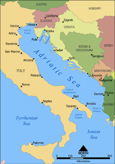
The Adriatic Sea is a body of water separating the Italian Peninsula from the Balkans. The Adriatic is the northernmost arm of the Mediterranean Sea, extending from the Strait of Otranto to the northwest and the Po Valley. The countries with coasts on the Adriatic are Albania, Bosnia and Herzegovina, Croatia, Italy, Montenegro and Slovenia.

The Port of Ravenna is an Italian seaport on the North Adriatic Sea in Ravenna, Italy. It is one of the top twenty Italian ports and top forty European ports.

The Po is the longest river in Italy. It is a river that flows eastward across northern Italy starting from the Cottian Alps. The Po flows either 652 km (405 mi) or 682 km (424 mi) – considering the length of the Maira, a right bank tributary. The headwaters of the Po are a spring seeping from a stony hillside at Pian del Re, a flat place at the head of the Val Po under the northwest face of Monviso. The Po then extends along the 45th parallel north before ending at a delta projecting into the Adriatic Sea near Venice.
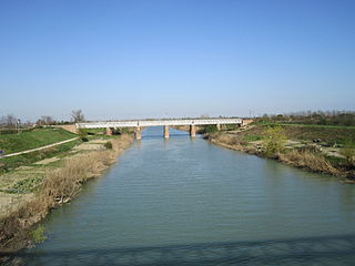
The Fiumi Uniti is a river in the province of Ravenna in the Emilia-Romagna region of Italy. The source of the river is the confluence of the rivers Montone and Ronco south of Ravenna. The river flows east 12 kilometers before entering the Adriatic Sea south of Lido Adriano.

