Portugal is a unitary state with delegated authority to three levels of local government that cover the entire country:

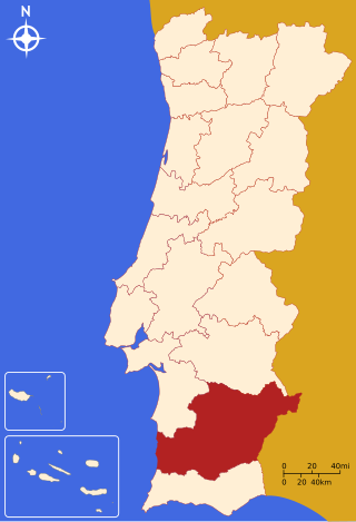
The Beja District is located in southern Portugal. The district capital is the city of Beja. It is the largest district of the country by area, comprising around 11% of Portuguese territory.

The Ribatejo is the most central of the traditional provinces of Portugal, with no coastline or border with Spain. The region is crossed by the Tagus river. The region contains some of the nation's richest agricultural land, and it produces most of the animals used in the Portuguese style of bullfighting.

Ferreira do Alentejo, or simply Ferreira, is a town and a municipality in Beja District in Portugal. The population in 2011 was 8,255, in an area of 648.25 km2.

Viana do Alentejo is a municipality in the District of Évora in Portugal. The population in 2011 was 5,743, in an area of 393.67 km2.

The Comunidade Intermunicipal da Lezíria do Tejo is an administrative division in Portugal. It was established as an Associação de Municípios in 1987, converted into a Comunidade Urbana in 2003, and converted into a Comunidade Intermunicipal in November 2008. It is also a NUTS3 subregion of the Alentejo Region. The seat of the intermunicipal community is the city of Santarém. Lezíria do Tejo comprises municipalities of the former districts of Santarém and Lisbon. The population in 2011 was 247,453, in an area of 4,275 square kilometres (1,651 sq mi). In the past, the territory of this administrative division was roughly entirely set in the former historical province of Ribatejo and had nothing to do with the former historical province of Alentejo. Lezíria is the Portuguese word for floodplain or freshwater marsh. Tejo is the name of the main river in the region. The Lezíria is a well-renowned center of intensive farming, horse breeding and animal husbandry.

Glassdrive–Q8–Anicolor is a Portuguese professional cycling team based in Vila Nova de Gaia. It is one of the European teams in UCI Continental Tour.

Zambujeira do Mar is a former civil parish in the municipality of Odemira, Alentejo region, Portugal. In 2013, the parish merged into the parish São Teotónio. Odemira Municipality in the Portuguese. It has a population of 911 inhabitants, dispersed over an area of 42.96 square kilometres (16.59 sq mi).

The Castle of Viana do Alentejo is a gothic castle constructed during the reconquest and settlement of the central region of the Portuguese Alentejo, located in the parish of Viana do Alentejo, municipality of the same name. Although a relatively low-profile design, in comparison to its contemporaries, the structure served the period of strife associated with expansion of Portuguese forces/authority into the southern Algarve.

The term "provinces" has been used throughout history to identify regions of continental Portugal. Current legal subdivisions of Portugal do not coincide with the provinces, but several provinces, in their 19th- and 20th-century versions, still correspond to culturally relevant, strongly self-identifying categories. They include:
Alfundão is a former civil parish in the municipality of Ferreira do Alentejo, Portugal. In 2013, the parish merged into the new parish Alfundão e Peroguarda.
Ferreira do Alentejo is a former civil parish in the municipality of Ferreira do Alentejo, Portugal. In 2013, the parish merged into the new parish Ferreira do Alentejo e Canhestros.
Figueira dos Cavaleiros is a freguesia in Ferreira do Alentejo, Portugal. The population in 2011 was 1,346, in an area of 154.20 km2.
Odivelas is a freguesia in Ferreira do Alentejo, Portugal. The population in 2011 was 542, in an area of 110.05 km2.
Peroguarda is a former civil parish in the municipality of Ferreira do Alentejo, Portugal. In 2013, the parish merged into the new parish Alfundão e Peroguarda.

Torrão is a civil parish and town, in the municipality of Alcácer do Sal, in the Portuguese district of Setúbal, bordering on the districts of Évora and the Beja. It is crossed by the river Xarrama River. The population in 2011 was 2,295, in an area of 372.39 km2.
Alfundão e Peroguarda is a civil parish in the municipality of Ferreira do Alentejo, Portugal. It was formed in 2013 by the merger of the former parishes Alfundão and Peroguarda. The population in 2011 was 1,227, in an area of 88.33 km2.
Ferreira do Alentejo e Canhestros is a civil parish in the municipality of Ferreira do Alentejo, Portugal. It was formed in 2013 by the merger of the former parishes Ferreira do Alentejo and Canhestros. The population in 2011 was 5,140, in an area of 295.66 km2.


