Cannington Nunnery

Last updated

Cannington Nunnery
CanningtonPriory.JPG
Monastery information
Order Benedictine
Establishedc. 1138
Disestablished1536
People
Founder(s)Roger de Curci
Site
Location Cannington, Somerset, England
Grid reference ST257396
Somerset UK location map.svg
Red pog.svg
Cannington Nunnery shown within Somerset
(grid reference ST257396 )

Cannington Nunnery was established around 1138 and dissolved in 1536 in Cannington, Somerset, England.

Cannington, Somerset village and civil parish in Somerset, UK

Cannington is a village and civil parish 3 miles (5 km) north-west of Bridgwater in the Sedgemoor district of Somerset, England. It lies on the west bank of the River Parret, and contains the hamlet of Edstock.

Somerset County of England

Somerset is a county in South West England which borders Gloucestershire and Bristol to the north, Wiltshire to the east, Dorset to the south-east and Devon to the south-west. It is bounded to the north and west by the Severn Estuary and the Bristol Channel, its coastline facing southeastern Wales. Its traditional border with Gloucestershire is the River Avon. Somerset's county town is Taunton.

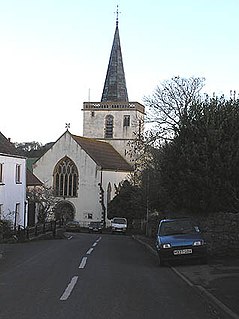
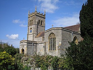
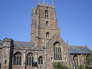
It was attached to the Church of St Mary. [1] [2]

Benedictine nuns (from Dorset), transferred to Colwich Abbey. The building was converted into a mansion and later reverted to being a nunnery. [3] It was disestablished as part of the dissolution of the monasteries in 1536. [4]

Dorset County of England

Dorset is a county in South West England on the English Channel coast. The ceremonial county comprises the unitary authority areas of Bournemouth, Christchurch and Poole and Dorset. Covering an area of 2,653 square kilometres (1,024 sq mi), Dorset borders Devon to the west, Somerset to the north-west, Wiltshire to the north-east, and Hampshire to the east. The county town is Dorchester which is in the south. After the reorganisation of local government in 1974 the county's border was extended eastward to incorporate the Hampshire towns of Bournemouth and Christchurch. Around half of the population lives in the South East Dorset conurbation, while the rest of the county is largely rural with a low population density.

Cannington Court incorporates some of the remains. [5]

Cannington Court building in Cannington, Somerset, UK

Cannington Court in the village of Cannington, Somerset, England was built around 1138 as the lay wing of a Benedictine nunnery, founded by Robert de Courcy. It has been designated as a Grade I listed building.

Related Research Articles

Stogursey

Stogursey is the name of a small village and civil parish in the Quantock Hills in Somerset, England. It is situated 3 miles (4.8 km) from Nether Stowey, and 8 miles (12.9 km) west of Bridgwater. The village is situated near the Bristol Channel, which bounds the parish on the north.

Amesbury Abbey was a Benedictine abbey of women at Amesbury in Wiltshire, England, founded by Queen Ælfthryth in about the year 979 on what may have been the site of an earlier monastery. That foundation was dissolved in 1177 by Henry II, who founded in its place a house of the Order of Fontevraud, known as Amesbury Priory.

Spaxton village in the United Kingdom

Spaxton is a small village and civil parish on the Quantocks in the Sedgemoor district of Somerset, South West England.

St Marys Abbey, Colwich

Saint Mary's Abbey in Colwich, Staffordshire is an English community of Roman Catholic nuns of the English Benedictine Congregation founded in 1623 at Cambrai, Flanders, in the Spanish Netherlands. During the French Revolution, the community was expelled from France and settled at The Mount, Colwich, in 1836, where it continues today.

Grade I listed buildings in Somerset Wikimedia list article

The Grade I listed buildings in Somerset, England, demonstrate the history and diversity of its architecture. The ceremonial county of Somerset consists of a non-metropolitan county, administered by Somerset County Council, which is divided into five districts, and two unitary authorities. The districts of Somerset are West Somerset, South Somerset, Taunton Deane, Mendip and Sedgemoor. The two administratively independent unitary authorities, which were established on 1 April 1996 following the breakup of the county of Avon, are North Somerset and Bath and North East Somerset. These unitary authorities include areas that were once part of Somerset before the creation of Avon in 1974.

St Marys Church, Cannington church in Sedgemoor, UK

The Church of St Mary is the parish church of Cannington, Somerset, England.

St Marys Church, Chedzoy church in Sedgemoor, UK

The Anglican Church of St Mary in Chedzoy, Somerset, England dates from the 13th century and has been designated as a grade I listed building.

Montacute Priory human settlement in United Kingdom

Montacute Priory was a Cluniac priory of the Benedictine order in Montacute, Somerset, England.

Buckland Priory human settlement in United Kingdom

Buckland Priory was established around 1167 in Lower Durston, Somerset, England.

Dunster Priory

Dunster Priory was established as a Benedictine monastery around 1100 in Dunster, Somerset, England.

Barrow Gurney Nunnery human settlement in United Kingdom

Barrow Gurney Nunnery was established around 1200 in Barrow Gurney Somerset, England.

Blackborough Priory

Blackborough Priory was a Benedictine monastic house in Norfolk, England, about 5 miles or 8 km south east of King's Lynn. The Ordnance Survey map shows the remains of fishponds nearby, which may have been for the use of the monastery.

St Leonard's Priory was a Benedictine nunnery in what is now east London, which gave its name to Bromley-St Leonards (better known as Bromley-by-Bow.

St Marys Church, Bromley St Leonards

St Mary's Church, Bow was a Church of England parish church in Bromley St Leonard's in east London. 'Bromley St Leonard's' was split from the parish of Stepney in 1536, reusing the priory church from the recently-dissolved St Leonard's Priory, a Benedictine nunnery. It was destroyed by bombing in World War II and obliterated by the building of the Blackwall Tunnel approach road, dividing the main residential body of the parish from the river front, though its churchyard survives.

References

  1. "Priory History". Cannington Online. Archived from the original on 20 July 2011. Retrieved 13 January 2008.
  2. "Church of St Mary". historicengland.org.uk. Retrieved 13 January 2008.
  3. "Houses of Benedictine nuns: The priory of Cannington". British History Online. Retrieved 13 January 2008.
  4. "'Houses of Benedictine nuns: The priory of Cannington',". A History of the County of Somerset: Volume 2. British History Online. Retrieved 6 January 2010.
  5. "Cannington Court". historicengland.org.uk. Retrieved 13 January 2008.

Coordinates: 51°09′01″N3°03′46″W / 51.1504°N 3.0627°W / 51.1504; -3.0627

Geographic coordinate system Coordinate system

A geographic coordinate system is a coordinate system that enables every location on Earth to be specified by a set of numbers, letters or symbols. The coordinates are often chosen such that one of the numbers represents a vertical position and two or three of the numbers represent a horizontal position; alternatively, a geographic position may be expressed in a combined three-dimensional Cartesian vector. A common choice of coordinates is latitude, longitude and elevation. To specify a location on a plane requires a map projection.