Lake of the Woods is a lake occupying parts of the Canadian provinces of Ontario and Manitoba and the U.S. state of Minnesota. Lake of the Woods is over 70 miles (110 km) long and wide, containing more than 14,552 islands and 65,000 miles (105,000 km) of shoreline. It is fed by the Rainy River, Shoal Lake, Kakagi Lake and other smaller rivers. The lake drains into the Winnipeg River and then into Lake Winnipeg. Ultimately, its outflow goes north through the Nelson River to Hudson Bay.
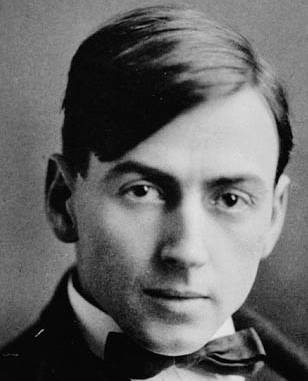
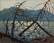
Thomas John Thomson was a Canadian artist active in the early 20th century. During his short career, he produced roughly 400 oil sketches on small wood panels and approximately 50 larger works on canvas. His works consist almost entirely of landscapes, depicting trees, skies, lakes, and rivers. He used broad brush strokes and a liberal application of paint to capture the beauty and colour of the Ontario landscape. Thomson's accidental death by drowning at 39 shortly before the founding of the Group of Seven is seen as a tragedy for Canadian art.

Algonquin Provincial Park is an Ontario provincial park located between Georgian Bay and the Ottawa River, mostly within the Unorganized South Part of Nipissing District. Established in 1893, it is the oldest provincial park in Canada. Additions since its creation have increased the park to its current size of about 7,653 km2 (2,955 sq mi). The park is contiguous with several smaller, administratively separate provincial parks that protect important rivers in the area, resulting in a larger total protected area.

Achray is an unincorporated place and former railway point in geographic Stratton Township in the Unorganized South Part of Nipissing District in northeastern Ontario, Canada. It lies in northern Algonquin Provincial Park on the northern shore of Grand Lake, part of the Barron River system, and functions today as a campground site.
The Ottawa Valley is the valley of the Ottawa River, along the boundary between Eastern Ontario and the Outaouais, Quebec, Canada. The valley is the transition between the Saint Lawrence Lowlands and the Canadian Shield. Because of the surrounding shield, the valley is narrow at its western end and then becomes increasingly wide as it progresses eastward. The underlying geophysical structure is the Ottawa-Bonnechere Graben. Approximately 1.3 million people reside in the valley, around 80% of whom reside in Ottawa. The total area of the Ottawa Valley is 2.4 million ha. The National Capital Region area has just over 1.4 million inhabitants in both provinces.

The Mattawa River is a river in central Ontario, Canada. It flows east from Trout Lake east of North Bay and enters the Ottawa River at the town of Mattawa. Counting from the head of Trout Lake, it is 76 kilometres (47 mi) long. The river's name comes from the Algonquin word for "meeting of waterways".

Opeongo Lake is a lake in the Saint Lawrence River drainage basin in the geographic townships of Bower, Dickson, Preston and Sproule in the Unorganized South Part of Nipissing District in Northeastern Ontario, Canada. It is the largest lake in Algonquin Provincial Park and the source of the Opeongo River. The lake's name comes from the Algonquian word opeauwingauk meaning "sandy narrows".

Kawartha Highlands Provincial Park is a 375-square-kilometre (145 sq mi) area of preserved wilderness and recreational areas in south-central Ontario, Canada. It is located to the north and east of the main belt of the Kawartha Lakes, primarily in the township of North Kawartha. It is the largest single area of preserved land in the southern part of the province.

The Amable du Fond River is a river in Nipissing District, in Northern Ontario, Canada.

Quetico Provincial Park is a large wilderness park in Northwestern Ontario, Canada, known for its excellent canoeing and fishing. The 4,760 km2 (1,180,000-acre) park shares its southern border with Minnesota's Boundary Waters Canoe Area Wilderness, which is part of the larger Superior National Forest. These large wilderness parks are often collectively referred to as the Boundary Waters or the Quetico-Superior Country.

Northern Tier High Adventure is a collection of high adventure bases run by the Boy Scouts of America in the Boundary Waters Canoe Area Wilderness of Minnesota, Ontario's Quetico Provincial Park and Canadian Crown Lands, Manitoba's Atikaki Provincial Wilderness Park, Woodland Caribou Provincial Park, and points beyond. Northern Tier is the oldest of the four National High Adventure Bases operated by the Boy Scouts of America; the others currently in operation are Philmont Scout Ranch in New Mexico, Florida Sea Base in the Keys, and The Summit in West Virginia. The oldest, largest and most prominent of the Northern Tier bases is the Charles L. Sommers National High Adventure Base. Central to its programs is trips into the Boundary Waters Canoe Area Wilderness (BWCA) and Quetico Provincial Park
South River is a village on Highway 124 near Algonquin Park in the Almaguin Highlands region of Parry Sound District of Ontario, Canada. It is about halfway between North Bay and Huntsville or a 3-hour drive (300 km) north from Toronto. South River has access to the Algonquin Park for canoeists at Kawawaymog. South River is home of Mikisew Provincial Park on the shores of Eagle Lake.

Camp Pathfinder is a boys' Summer camp in Algonquin Provincial Park, Ontario, Canada. The camp is best known for its canoe tripping program. Pathfinder follows a tradition of using wood and canvas canoes. Several other camps in Algonquin and elsewhere follow a similar tradition of tripping with, building and restoring canvas canoes. Pathfinder's canoes are painted a distinctive bright red. The current owners are Will Hopkins -- himself once a Pathfinder camper -- and his wife Diane. Will serves as Camp Director.

Temagami, formerly spelled Timagami, is a municipality in northeastern Ontario, Canada, in the Nipissing District with Lake Temagami at its heart.
The Highland Inn (1908–1957) was a year-round resort hotel built and operated by the Grand Trunk Railway (GTR), in Ontario’s Algonquin Provincial Park. It was located near the park offices on the northern edge of Cache Lake, and was a focal point for the park for many years. Wishing to return the park lands to a more natural state, the Inn was purchased by the Ontario Government in 1956 and removed. Today all that remains are traces of the concrete stairs and platform that met the CNR line, which was lifted after departure of the last train in 1959.

Big Doe Camp was a boys' residential summer camp located on Big Doe Lake not far from the village of Burk's Falls, Ontario.
Magnetawan Lake(French: lac Magnetawan) is a lake in Nipissing District, Ontario, Canada. Magnetawan Lake is located just within the boundaries of Algonquin Provincial Park. Being located in the park the lake and its surroundings are protected. Magnetawan Lake also serves as an access point into Algonquin Park with a parking lot located on the shore acting as an entrance point for many canoeists. Algonquin Park Canoe routes pass through the lake and four campsites can be found on the shore as well as two portages. The two portages 340 m and 125 m found on Magnetawan Lake connect this lake with Little Eagle Lake and Hambone Lake respectively.
The South is a river in the Almaguin Highlands region of Parry Sound District, Ontario, beginning in the Western Uplands of Algonquin Provincial Park and emptying into Lake Nipissing. The river takes its name from an arm of Lake Nipissing into which it flows, South Bay.
The Gilmour Lumber Company was one of the giants of the Canadian timber industry. Their involvement in lumbering began modestly in the 1790s in the area of Glasgow, Scotland where Allan Gilmour Sr. started a small timber merchandising business. In 1804 he entered into a partnership with his cousins John and Arthur and formed Pollock, Gilmour and Company. Pollock, Gilmour and Company became ship owners and imported products in Europe and the Baltic region.

The Canadian painter Tom Thomson died on 8 July 1917, on Canoe Lake in Algonquin Provincial Park in Nipissing District, Ontario, Canada. After Thomson drowned in the water, his upturned canoe was discovered later that afternoon and his body eight days later. Many theories regarding Thomson's death—including that he was murdered or committed suicide—have become popular in the years since his death, though these ideas lack any substantiation.