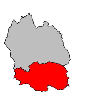
The arrondissement of Florac is an arrondissement of France in the Lozère department in the Occitanie région. Its INSEE code is 481 and its capital city is Florac-Trois-Rivières.

The arrondissement of Mende is an arrondissement of France in the Lozère department in the Occitanie région. Its INSEE code is 482 and its capital city, and prefecture of the department, is Mende.
The following is a list of the 13 cantons of the Lozère department, in France, following the French canton reorganisation which came into effect in March 2015:
The canton of Châteauneuf-de-Randon is a former canton of France, located in the Lozère department, in the Languedoc-Roussillon region. It was disbanded following the French canton reorganisation which came into effect in March 2015. It consisted of 8 communes, which joined the canton of Grandrieu in 2015.

The GR 70, also known as the Chemin de Stevenson or the Robert Louis Stevenson Trail, is a Grande Randonnée that runs for approximately 225 kilometres (140 mi) through the French departments of Haute-Loire, Lozère and Gard in a generally north–south direction from Le Monastier-sur-Gazeille to Saint-Jean-du-Gard. It follows approximately the route taken by Robert Louis Stevenson in 1878, a journey described in his book Travels with a Donkey in the Cévennes.
The canton of Aumont-Aubrac is an administrative division of the Lozère department, southern France. Its borders were modified at the French canton reorganisation which came into effect in March 2015. Its seat is in Peyre-en-Aubrac.
The canton of La Canourgue is an administrative division of the Lozère department, southern France. Its borders were modified at the French canton reorganisation which came into effect in March 2015. Its seat is in La Canourgue.
The canton of Florac is an administrative division of the Lozère department, southern France. Its borders were modified at the French canton reorganisation which came into effect in March 2015. Its seat is in Florac-Trois-Rivières.
The canton of Chirac is an administrative division of the Lozère department, southern France. It was created at the French canton reorganisation which came into effect in March 2015. Its seat is in Bourgs-sur-Colagne.
The canton of Le Collet-de-Dèze is an administrative division of the Lozère department, southern France. It was created at the French canton reorganisation which came into effect in March 2015. Its seat is in Le Collet-de-Dèze.
The canton of Grandrieu is an administrative division of the Lozère department, southern France. Its borders were modified at the French canton reorganisation which came into effect in March 2015. Its seat is in Grandrieu.
The canton of Saint-Étienne-du-Valdonnez is an administrative division of the Lozère department, southern France. It was created at the French canton reorganisation which came into effect in March 2015. Its seat is in Saint-Étienne-du-Valdonnez.
The canton of Marvejols is an administrative division of the Lozère department, southern France. Its borders were modified at the French canton reorganisation which came into effect in March 2015. Its seat is in Marvejols.
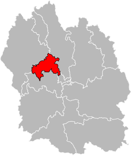
The cantons of Mende are administrative divisions of the Lozère department, in southern France. Since the French canton reorganisation which came into effect in March 2015, the town of Mende is subdivided into 2 cantons. Their seat is in Mende.
The canton of Saint-Alban-sur-Limagnole is an administrative division of the Lozère department, southern France. Its borders were modified at the French canton reorganisation which came into effect in March 2015. Its seat is in Saint-Alban-sur-Limagnole.
The canton of Saint-Chély-d'Apcher is an administrative division of the Lozère department, southern France. Its borders were modified at the French canton reorganisation which came into effect in March 2015. Its seat is in Saint-Chély-d'Apcher.
The canton of Pays de la Force is an administrative division of the Dordogne department, southwestern France. It was created at the French canton reorganisation which came into effect in March 2015. Its seat is in Prigonrieux.
The canton of Saint-Céré is an administrative division of the Lot department, southern France. Its borders were modified at the French canton reorganisation which came into effect in March 2015. Its seat is in Saint-Céré.
The canton of Saint-Florentin is an administrative division of the Yonne department, central France. Its borders were modified at the French canton reorganisation which came into effect in March 2015. Its seat is in Saint-Florentin.

