
Nuits-Saint-Georges is a commune in the arrondissement of Beaune of the Côte-d'Or department in eastern France. It lies in the Bourgogne-Franche-Comté region.
The Côte d'Or is a limestone escarpment in Burgundy, France that lends its name to the department which was formed around it. It stretches from Dijon in the north to the river Dheune to the south, overlooking the valley of the Saône to the east.

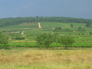
Gevrey-Chambertin is a commune in the Côte-d'Or department of France in the Bourgogne-Franche-Comté region in eastern France.

The Route des Grands Crus is the name of a tourist route situated in Burgundy, France.

The arrondissement of Beaune is an arrondissement of France in the Côte-d'Or department in the Bourgogne-Franche-Comté region. Since the January 2017 reorganization of the arrondissements of Côte-d'Or, it has 223 communes.
The following is a list of the 23 cantons of the Côte-d'Or department, in France, following the French canton reorganisation which came into effect in March 2015:
The Canton of Roye is a canton situated in the department of the Somme and in the Picardie region of northern France.
The canton of Charlieu is a French administrative division located in the department of Loire and the Auvergne-Rhône-Alpes region. At the French canton reorganisation which came into effect in March 2015, the canton was expanded from 14 to 31 communes:

The canton of Barentin is an administrative division of the Seine-Maritime department, in northern France. It was created at the French canton reorganisation which came into effect in March 2015. Its seat is in Barentin.
The canton of Arnay-le-Duc is an administrative division of the Côte-d'Or department, eastern France. Its borders were modified at the French canton reorganisation which came into effect in March 2015. Its seat is in Arnay-le-Duc.
The canton of Auxonne is an administrative division of the Côte-d'Or department, eastern France. Its borders were modified at the French canton reorganisation which came into effect in March 2015. Its seat is in Auxonne.
The canton of Châtillon-sur-Seine is an administrative division of the Côte-d'Or department, eastern France. Its borders were modified at the French canton reorganisation which came into effect in March 2015. Its seat is in Châtillon-sur-Seine.
The canton of Genlis is an administrative division of the Côte-d'Or department, eastern France. Its borders were modified at the French canton reorganisation which came into effect in March 2015. Its seat is in Genlis.
The canton of Longvic is an administrative division of the Côte-d'Or department, eastern France. It was created at the French canton reorganisation which came into effect in March 2015. Its seat is in Longvic.
The canton of Montbard is an administrative division of the Côte-d'Or department, eastern France. Its borders were modified at the French canton reorganisation which came into effect in March 2015. Its seat is in Montbard.
The canton of Semur-en-Auxois is an administrative division of the Côte-d'Or department, eastern France. Its borders were modified at the French canton reorganisation which came into effect in March 2015. Its seat is in Semur-en-Auxois.
The canton of Talant is an administrative division of the Côte-d'Or department, eastern France. It was created at the French canton reorganisation which came into effect in March 2015. Its seat is in Talant.
The canton of Étain is an administrative division of the Meuse department, northeastern France. Its borders were modified at the French canton reorganisation which came into effect in March 2015. Its seat is in Étain.
The canton of Stenay is an administrative division of the Meuse department, northeastern France. Its borders were modified at the French canton reorganisation which came into effect in March 2015. Its seat is in Stenay.

