
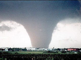
A tornado is a violently rotating column of air that is in contact with both the surface of the Earth and a cumulonimbus cloud or, in rare cases, the base of a cumulus cloud. It is often referred to as a twister, whirlwind or cyclone, although the word cyclone is used in meteorology to name a weather system with a low-pressure area in the center around which, from an observer looking down toward the surface of the Earth, winds blow counterclockwise in the Northern Hemisphere and clockwise in the Southern. Tornadoes come in many shapes and sizes, and they are often visible in the form of a condensation funnel originating from the base of a cumulonimbus cloud, with a cloud of rotating debris and dust beneath it. Most tornadoes have wind speeds less than 180 kilometers per hour, are about 80 meters across, and travel several kilometers before dissipating. The most extreme tornadoes can attain wind speeds of more than 480 kilometers per hour (300 mph), are more than 3 kilometers (2 mi) in diameter, and stay on the ground for more than 100 km.

Skywarn is a program of the National Weather Service (NWS). Its mission is to collect reports of localized severe weather in the United States. These reports are used to aid forecasters in issuing and verifying severe weather watches and warnings and to improve the forecasting and warning processes and the tools used to collect meteorological data. Reports are also used by local emergency managers and public safety organizations.
A tornado warning is a severe weather warning product of the National Weather Service that is issued by regional offices of weather forecasting agencies throughout the world to alert the public when a tornado has been reported or indicated by weather radar within the parent severe thunderstorm. It can be issued after a tornado, funnel cloud and rotation in the clouds has been witnessed by the public, storm chasers, emergency management or law enforcement, and indicates that residents in the affected areas should take immediate safety precautions.

In the United States and Canada, the Amateur Radio Emergency Service (ARES) is a corps of trained amateur radio operator volunteers organized to assist in public service and emergency communications. It is organized and sponsored by the American Radio Relay League and the Radio Amateurs of Canada.
The Edmonton tornado of 1987, an event also known as Black Friday to Edmontonians, was a powerful and devastating tornado that ripped through the eastern parts of Edmonton, Alberta, Canada and parts of neighbouring Strathcona County on the afternoon of Friday, July 31, 1987. It was one of seven other tornadoes in central Alberta the same day.
Weather spotting is observing weather for the purpose of reporting to a larger group or organization. Examples include National Weather Service (NWS) co-op observers and Skywarn storm spotters.
The Tornado and Storm Research Organisation (TORRO) was founded by Terence Meaden in 1974. Originally called the Tornado Research Organisation it was expanded in 1982 following the inclusion of the Thunderstorm Census Organisation (TCO) after the death of its founder Morris Bower and his wife. The current Head of TORRO is Paul Knightley, a professional meteorologist.

StormReady is a community preparedness program in the United States that encourages government entities and commercial gathering sites to prepare for severe storms. The program, sponsored by the United States National Weather Service, issues recognition to communities and sites across the country that demonstrate severe weather readiness. The program is voluntary, and provides communities with clear-cut advice from a partnership with the local National Weather Service Office, state and local emergency managers, and the media. The program has been credited with saving the lives of more than 50 movie-goers in Van Wert County, Ohio in November 2002. As of June 1, 2011, there were 1,752 StormReady sites in 50 states.
Convective storm detection is the meteorological observation, and short-term prediction, of deep moist convection (DMC). DMC describes atmospheric conditions producing single or clusters of large vertical extension clouds ranging from cumulus congestus to cumulonimbus, the latter producing thunderstorms associated with lightning and thunder. Those two types of clouds can produce severe weather at the surface and aloft.
Storm spotting is a form of weather spotting in which observers watch for the approach of severe weather, monitor its development and progression, and actively relay their findings to local authorities.
Skywarn Europe is a network of volunteer storm spotters throughout Europe based on the U.S. Skywarn program.
The Prairie and Arctic Storm Prediction Centre (PASPC), is tasked with forecasting weather for the public and mariners in the Canadian Prairie Provinces, the Northwest Territories, Nunavut Territory, and adjacent domestic waters. The PASPC operations are split between an office in Winnipeg, Manitoba and an office in Edmonton, Alberta. The agency provides continuous weather monitoring and issues weather forecasts, weather warnings and weather watches as a part of this process. Daily severe weather discussions are issued to give additional information on a region that is becoming a severe weather threat, stating whether a watch or warning is likely and details thereof.
The Spotter Network (SN) is a system that utilizes storm spotter and chaser reports of location and severe weather in a centralized framework for use by coordinators such as emergency managers, Skywarn and related spotter organizations, and the National Weather Service. It uses GPS to provide accurate and automated position data of storm spotters and chasers for coordination and reporting, which in turn provides ground truth to public servants engaged in the protection of life and property. The network is a combination of locally installed software for position and status reporting and web-based processing, mapping, and reporting.
The following is a glossary of tornado terms. It includes scientific as well as selected informal terminology.

Alan Roger Moller was an American meteorologist, storm chaser, nature and landscape photographer known for advancing spotter training and bridging operational meteorology with research.

A destructive, two-day tornado outbreak affected the Great Lakes region of the United States and the National Capital Region of Canada in late-September. A total of 37 tornadoes were confirmed, including a long-tracked EF3 tornado that moved along a 80 km (50 mi) path from near Dunrobin, Ontario to Gatineau, Quebec, and an EF2 tornado in the Nepean sector of Ottawa. The tornadoes in Ottawa-Gatineau were declared one of the ten most significant weather events of 2018 in Canada by the Meteorological Service of Canada.