
Lillie Glacier is a large glacier in Antarctica, about 100 nautical miles (190 km) long and 10 nautical miles (19 km) wide. It lies between the Bowers Mountains on the west and the Concord Mountains and Anare Mountains on the east, flowing to Ob' Bay on the coast and forming the Lillie Glacier Tongue.
The Electoral district of Maryborough and Daylesford was an electoral district of the Victorian Legislative Assembly. It included the towns of Maryborough and Daylesford, around 168 km and 155 km north-west of Melbourne respectively.

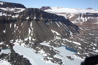
Sabine Glacier is a 13.5 km long glacier on the north side of Detroit Plateau, flowing from Mount Bris and Tsarevets Buttress northwards along the east slopes of Korten Ridge, and terminating at the sea in Jordanoff Bay on Davis Coast in Graham Land, Antarctica. Captain Henry Foster gave the name "Cape Sabine" in 1829 to a feature lying southeast of Cape Kater but it has not been possible to identify that cape. This toponym preserves the early use of Sabine in this area. Sir Edward Sabine (1788-1883), English astronomer and geodesist, was a member of the committee which planned the 1829 voyage of Foster in the Chanticleer.
Mount Alford is a flat-topped, ice-free mountain (1,480 m) at the south side of Boggs Valley in the Helliwell Hills. Mapped by United States Geological Survey (USGS) from surveys and U.S. Navy air photos, 1960-63. Named by Advisory Committee on Antarctic Names (US-ACAN) for Montague Alford, United States Antarctic Research Program (USARP) geologist at McMurdo Station, 1967-68. The mountain is situated on the Pennell Coast, a portion of Antarctica lying between Cape Williams and Cape Adare.

The borders of the oceans are the limits of the Earth's oceanic waters. The definition and number of oceans can vary depending on the adopted criteria.
Cape Blake is a rocky cape on the Organ Pipe Cliffs, 4 nautical miles (7 km) west of Cape Wild. Discovered by the Australasian Antarctic Expedition (1911–14) under Douglas Mawson, who named it for L.R. Blake, geologist and cartographer with the Macquarie Island party of the expedition.
Boggs Valley is a glaciated valley, heavily strewn with morainal debris, which indents the east side of the Helliwell Hills between Mount Van der Hoeven and Mount Alford, Victoria Land, Antarctica. The geographical feature was first mapped by the United States Geological Survey from surveys and from U.S. Navy air photos, 1960–63, and named by the Advisory Committee on Antarctic Names for William J. Boggs, United States Antarctic Research Program biologist who performed his biological observations while situated at McMurdo Station, Hut Point Peninsula, Ross Island, during the summer of 1967–68. The valley lies situated on the Pennell Coast, a portion of Antarctica lying between Cape Williams and Cape Adare.
Cape Close is a cape on the coast of Enderby Land, 30 nautical miles (60 km) west of Cape Batterbee. It was discovered by the British Australian New Zealand Antarctic Research Expedition, 1929–31, under Mawson, who named it for Sir Charles Close, President of the Royal Geographical Society, 1927–30.
DeGalan Peak is a peak that rises to 2,470 metres (8,100 ft) at the head of Magnis Valley in the Britannia Range. It was named after Lee DeGalan, a contractor employee in charge of United States Antarctic Program cargo shipments out of Port Hueneme, CA, for more than 20 years.

Mushketov Glacier is a large glacier trending northeastward, draining the area between the Wohlthat Mountains on the west and the Weyprecht, Payer and Lomonosov Mountains on the east, in Queen Maud Land. Discovered and plotted from air photos by German Antarctic Expedition, 1938-39. Replotted from air photos and surveys by Soviet Antarctic Expedition, 1958–59, and named after Ivan V. Mushketov (1850–1902), Russian geologist and geographer.
Mount Frustum is a large pyramidal shaped table mountain, 3,100 metres (10,200 ft) high, standing between Mount Fazio and Scarab Peak in the southern part of Tobin Mesa, in Victoria Land, Antarctica. The topographical feature was so named by the northern party of the New Zealand Geological Survey Antarctic Expedition, 1962–63, for its frustum-like shape. The mountain lies situated on the Pennell Coast, a portion of Antarctica lying between Cape Williams and Cape Adare.
Deschanel Peak is the summit of an isolated, partly ice-covered mountain, 750 metres (2,460 ft) high, rising from the south part of the glacier close southeast of Cape Berteaux on the west coast of the Antarctic Peninsula. The approved name derives from "Sommet Deschanel" given by J.B. Charcot, leader of the French Antarctic Expedition, in January 1909.
Eliza Cone is a rock with an archway through it standing 1 nautical mile (2 km) west of Cape McNab on the south end of Buckle Island, in the Balleny Islands. It is located adjacent to Scott Cone, the two features appear to have been named after John Balleny's schooner, the Eliza Scott, in which he discovered the Balleny Islands in February 1839.
Fraser Nunatak is a nunatak rising to 2,070 metres (6,800 ft), 22 kilometres (14 mi) south west of the Wilhoite Nunataks and west of the Churchill Mountains in Antarctica. It was named in honor of Graham Fraser, who has had some 45 years of Antarctic experience and led geomagnetic pulsation research over 11 seasons from 1989 onwards.
Mendeleyev Glacier is a glacier, 10 nautical miles (19 km) long, draining northeast through the northern outcrops of the Payer Mountains, in Queen Maud Land, Antarctica. It was mapped from air photos and surveys by the Soviet Antarctic Expedition, 1960–61, and named after Russian chemist Dmitri Mendeleev, whose surname may also be transliterated as "Mendeleyev".
Spear Glacier is a glacier between the Hauberg Mountains and Peterson Hills, in southern Palmer Land. Mapped by United States Geological Survey (USGS) from surveys and U.S. Navy air photos, 1961-67. Named by Advisory Committee on Antarctic Names (US-ACAN) for Milton B. Spear, construction electrician at Eights Station in 1965.
Kamenev Bight is a shallow embayment about 25 nautical miles (50 km) wide in the ice shelf fringing the coast of Queen Maud Land, Antarctica. Cape Krasinskiy, an ice cape, marks the western end of the bight which lies 60 nautical miles (110 km) northwest of the Schirmacher Hills. The bight was photographed from the air by the Sixth Norwegian Antarctic Expedition in 1958–59 and was mapped from these photos. It was also mapped in 1961 by the Soviet Antarctic Expedition who named it for S.S. Kamenev, an organizer of Arctic expeditions.
Vaughan Glacier is a tributary glacier, 10 nautical miles (18 km) long, draining eastward from Mount Vaughan to enter Scott Glacier just south of Taylor Ridge, in the Hays Mountains of the Queen Maud Mountains. It was mapped by the United States Geological Survey (USGS) from surveys and U.S. Navy air photos, 1960–64, and was named by the Advisory Committee on Antarctic Names (US-ACAN) in association with Mount Vaughan.
Romulus Glacier is a glacier, 7 nautical miles (13 km) long and 2 nautical miles (3.7 km) wide, which flows from the north slopes of Mount Lupa westward to Rymill Bay between the Blackwall Mountains and Black Thumb, on the west coast of Graham Land. First surveyed in 1936 by the British Graham Land Expedition (BGLE) under Rymill. Resurveyed in 1948-49 by the Falkland Islands Dependencies Survey (FIDS), who so named it for its association with Remus Glacier, whose head lies near the head of this glacier.


