Savage Island or Savage Islands may refer to:

Anvers Island or Antwerp Island or Antwerpen Island or Isla Amberes is a high, mountainous island 61 km long, the largest in the Palmer Archipelago of Antarctica. It was discovered by John Biscoe in 1832 and named in 1898 by the Belgian Antarctic Expedition under Adrien de Gerlache after the province of Antwerp in Belgium. It lies south-west of Brabant Island at the south-western end of the group. The south-western coastline of the island forms part of the Southwest Anvers Island and Palmer Basin Antarctic Specially Managed Area. Cormorant Island, an Important Bird Area, lies 1 km off the south coast.
Beechey Island is an island located in the Arctic Archipelago of Nunavut, Canada, in Wellington Channel. It is separated from the southwest corner of Devon Island by Barrow Strait. Other features include Wellington Channel, Erebus Harbour, and Terror Bay.
John Barrow may refer to:
Brevoort Island is a small, uninhabited island located in the Davis Strait off the eastern coast of Baffin Island in the Qikiqtaaluk Region of northern Canada's territory of Nunavut. The island is a member of the Arctic Archipelago and lies north of Cape Murchison, opposite the Cumberland Peninsula.

Barrow Strait is a shipping waterway in Northern Canada's territory of Nunavut. Forming part of the Parry Channel, the strait separates several large islands including Cornwallis Island and Devon Island to the north, from Prince of Wales Island, Somerset Island, and Prince Leopold Island to the south.
Griffith Island lies within the Arctic Archipelago in the Qikiqtaaluk Region of northern Canada's territory of Nunavut. It is one of the mid-channel islands in the western sector of Barrow Strait.
Walrus Island may refer to:

The Parry Channel is a natural waterway through the central Canadian Arctic Archipelago. Its eastern two-thirds lie in the territory of Nunavut, while its western third lies in the Northwest Territories. It runs east to west, connecting Baffin Bay in the east with the Beaufort Sea in the west. Its eastern end is the only practical entrance to the Northwest Passage. Its western end would be a natural exit from the archipelago were it not filled with ice. The channel separates the Queen Elizabeth Islands to the north from the rest of Nunavut.
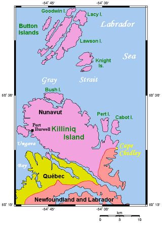
The Cape Chidley Islands are members of the Arctic Archipelago in the territory of Nunavut. They are located in the Labrador Sea at the south end of the entrance to the Hudson Strait, north of Killiniq Island's Cape Chidley, and separated from Killiniq Island by the MacGregor Strait.
Fairholme Island is a member of the Queen Elizabeth Islands and the Arctic Archipelago in the territory of Nunavut. It is an irregularly shaped island located in the Penny Strait, between John Barrow Island and the entrance to Barrow Harbour, Devon Island. Sir John Barrow Monument is to the southeast.
John Barrow Island is a member of the Queen Elizabeth Islands and the Arctic Archipelago in the territory of Nunavut. It is an elongated island located midway in the Penny Strait between Bathurst Island and Devon Island.
Hyde Parker Island is a member of the Queen Elizabeth Islands and the Arctic Archipelago in the territory of Nunavut. It is an irregularly shaped island located in the Penny Strait, between Bathurst Island and Devon Island. John Barrow Island lies directly to the north, while Sir John Barrow Monument is to the east.
Trinity Island may refer to:
Garrett Island is an island of the Arctic Archipelago, in the territory of Nunavut. It lies in the Barrow Strait, between Bathurst Island and Lowther Island.
Outcast Islands may refer to:
Hoseason Island is an island 6 nautical miles long and 3 nautical miles wide, lying 20 nautical miles west of Trinity Island in the Palmer Archipelago, Antarctica.
Ward Hunt (1810–1886) is a U.S. politician and jurist.
This page is based on this
Wikipedia article Text is available under the
CC BY-SA 4.0 license; additional terms may apply.
Images, videos and audio are available under their respective licenses.