
Cape Morris Jesup is a headland in Peary Land, Greenland.
Cape Farewell is a headland on the southern shore of Egger Island, Nunap Isua Archipelago, Greenland. As the southernmost point of the country, it is one of the important landmarks of Greenland.
Tasiilap Karra or Cape Gustav Holm is a headland in eastern Greenland, Sermersooq municipality.
Cape Atholl, also known as Kangaarasuk, is a headland in Northwest Greenland, Avannaata municipality.

Cape Morton is a headland in North Greenland in Avannaata municipality. The cape is named after Arctic explorer William Morton, who surveyed the Nares Strait area together with Hans Hendrik in June 1854 during the Second Grinnell Expedition.
Cape Desolation, also known as 'Cape Brill', is a headland in southwest Greenland in the Kujalleq municipality.
Cape Brewster is a headland in the Greenland Sea, east Greenland, Sermersooq municipality.
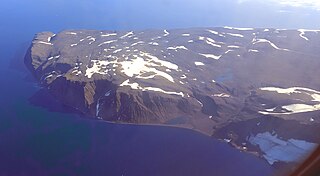
Cape Nansen is a headland in the Greenland Sea, east Greenland, Sermersooq municipality. This cape is named after Fridtjof Nansen. Cape Nansen is an important geographical landmark.
Cape J.A.D. Jensen is a headland in the North Atlantic Ocean, east Greenland, Sermersooq municipality. This cape is named after J. A. D. Jensen, an officer of the Danish Navy and Arctic explorer.

Cape Bridgman is a headland in the Wandel Sea, Arctic Ocean, northeast Greenland.

Cape Steen Bille or Kap Bille, also known as Kangeq, is a headland in the North Atlantic Ocean, southeast Greenland, Kujalleq municipality.
Cape Gray is a headland in North Greenland. Administratively it is part of the Northeast Greenland National Park.
Cape Cleveland is a headland in North Greenland. Administratively it is part of the Northeast Greenland National Park.
Cape Washington is a headland in North Greenland. Administratively it belongs to the Northeast Greenland National Park.
Cape Harald Moltke is a headland in Peary Land, North Greenland. Administratively it is part of the Northeast Greenland National Park.
Cape Brown is a headland in the Greenland Sea, east Greenland, Sermersooq municipality.
Cape Biot is a headland in the Greenland Sea, Northeast Greenland, Sermersooq municipality.
Cape Simpson is a headland in the Greenland Sea, Northeast Greenland. Administratively it is part of the Northeast Greenland National Park.
Cape Bismarck is a headland in King Frederick VIII Land, Northeast Greenland. Administratively it is part of the Northeast Greenland National Park.
Cape Eiler Rasmussen is a broad headland in the Wandel Sea, Arctic Ocean, northernmost Greenland. Administratively it is part of the Northeast Greenland National Park.


