
Interstate 95 (I-95) is the main north–south Interstate Highway on the East Coast of the United States, running from U.S. Route 1 (US 1) in Miami, Florida, north to the Houlton–Woodstock Border Crossing between Maine and the Canadian province of New Brunswick. The highway largely parallels the Atlantic coast and US 1, except for the portion between Savannah, Georgia, and Washington, D.C., and the portion between Portland and Houlton in Maine, both of which follow a more direct inland route.

E-ZPass is an electronic toll collection system used on toll roads, toll bridges, and toll tunnels in the Eastern, Midwestern, and Southeastern United States. The E-ZPass Interagency Group (IAG) consists of member agencies in several states, which use the same technology and allow travelers to use the same transponder on toll roads throughout the network.

U.S. Route 6 (US 6) or U.S. Highway 6 (US 6), also called the Grand Army of the Republic Highway, honoring the American Civil War veterans association, is a main route of the United States Numbered Highway System. While it currently runs east-northeast from Bishop, California, to Provincetown, Massachusetts, the route has been modified several times. The highway's longest-lasting routing, from 1936 to 1964, had its western terminus at Long Beach, California. During this time, US 6 was the longest highway in the country.
Route 24 is a 40.91-mile-long (65.84 km) freeway south of Interstate 93 (I-93) in southeastern Massachusetts, linking Fall River with the Boston metropolitan area. It begins in the south in Fall River at the border with Tiverton, Rhode Island, and runs north to an interchange with I-93/US 1 in Randolph. Route 24 is also known as the Fall River Expressway, and officially as the Amvets Highway. Route 24 has a total of 21 interchanges

Interstate 495 (I-495) is an auxiliary route of I-95 in the US state of Massachusetts, maintained by the Massachusetts Department of Transportation (MassDOT). Spanning 121.56 miles (195.63 km), it is the second-longest auxiliary route in the Interstate Highway System, being roughly 11 miles (18 km) shorter than I-476 in Pennsylvania.

Interstate 84 (I-84) is an Interstate Highway in the Northeastern United States that extends almost 233 miles from Dunmore, Pennsylvania, near Scranton at an interchange with I-81 east to Sturbridge, Massachusetts, at an interchange with the Massachusetts Turnpike (I-90). Among the major cities that the road passes through is Hartford, Connecticut, and the road provides a major portion of the primary route between New York City and Boston. Another highway named I-84 is located in the Northwestern United States.

Interstate 195 (I-195) is an auxiliary Interstate Highway running a combined 44.55 miles (71.70 km) in the US states of Rhode Island and Massachusetts. It travels from a junction with I-95 in Providence, Rhode Island, east to a junction with I-495 and Massachusetts Route 25 in Wareham, Massachusetts. It runs east–west and passes through the cities of Fall River, Massachusetts, and New Bedford, Massachusetts. The portion of I-195 in East Providence is also known as the East Providence Expressway.

Interstate 395 (I-395) is an auxiliary Interstate Highway in the U.S. states of Connecticut and Massachusetts; it is maintained by the Connecticut Department of Transportation (CTDOT) and the Massachusetts Department of Transportation (MassDOT). Spanning nearly 67 miles (108 km) on a south–north axis, it is the only spur route of I-95 in Connecticut. The 36-mile (58 km) section between its splits from I-95 in East Lyme and SR 695 in Plainfield is a component highway of the Connecticut Turnpike. Within that state, the highway is named the American Ex-Prisoner of War Memorial Highway from Plainfield to Thompson.
Route 78, also known as the Westerly Bypass, is a two-lane divided freeway between Stonington, Connecticut, to Westerly, Rhode Island. The route is about 4.6 miles (7.4 km) long and begins at Connecticut Route 2 in Stonington, crossing into Rhode Island at the Pawcatuck River, where it continues to U.S. Route 1 in Westerly. The route was constructed in 1979, after a sixteen-year delay. The designation was to become part of the Orient Point–Watch Hill Bridge, but this plan was later dropped. The route was given the memorial name of Veterans Way in 2004.

Route 25 is a 10-mile-long (16 km) freeway located in Plymouth County and Barnstable County, Massachusetts, United States. The route is a nominally east–west highway, and less commonly known as the Blue Star Memorial Highway. An eastward continuation of Interstate 495, Route 25 provides freeway access to Cape Cod. The route's western terminus is at a trumpet interchange with I-495 and I-195 in West Wareham. The route has three numbered interchanges along its length before terminating at the northern end of the Bourne Bridge in Bourne; the mainline of Route 25 continues across the bridge and over the Cape Cod Canal as Massachusetts Route 28 south.
The Connecticut Turnpike is a freeway and former toll road in the U.S. state of Connecticut; it is maintained by the Connecticut Department of Transportation (ConnDOT). Spanning approximately 128 miles (206 km) along a generally west–east axis, its roadbed is shared with Interstate 95 (I-95) for 88 miles (142 km) from the New York state border in Greenwich to East Lyme; I-395 for 36 miles (58 km) from East Lyme to Plainfield; and SR 695 for four miles (6.4 km) from Plainfield to the Rhode Island state line at U.S. Route 6 (US 6) in Killingly. The turnpike briefly runs concurrently with US 1 from Old Saybrook to Old Lyme and Route 2A from Montville to Norwich.

Route 28 is a 151.93-mile-long (244.51 km) nominally south–north state highway in the U.S. state of Massachusetts, running from the town of Eastham via Boston to the New Hampshire state line in Methuen. Following the route from its nominally southern end, Route 28 initially heads south to the town of Chatham then turns west to follow along the south shore of Cape Cod. In Falmouth, Route 28 turns north and continues through the western part of Plymouth County and the eastern part of Norfolk County; it then passes through downtown Boston before heading north via Lawrence to the New Hampshire state line, where it continues as New Hampshire Route 28.
Interstate 95 (I-95) is the main north–south Interstate Highway on the East Coast of the United States, running generally southwest–northeast through the US state of Rhode Island. It runs from the border with Connecticut near Westerly, through Warwick and Providence, and to the Massachusetts state line in Pawtucket. It has two auxiliary routes, both of which enter Massachusetts—I-195, a spur from Providence east to Cape Cod, and I-295, a western bypass of the Providence metropolitan area.
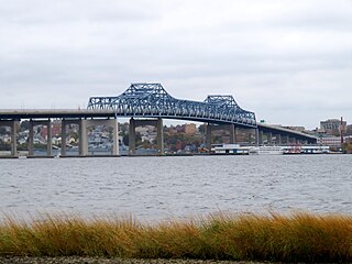
The Charles M. Braga Jr. Memorial Bridge, also known as the Braga Bridge, or simply, The Braga, is a through truss bridge that carries Interstate 195 over the Taunton River between the town of Somerset and the city of Fall River, near the mouth of the Quequechan River at the confluence with Mount Hope Bay. At just over a mile long, The Braga Bridge spans 1.25 miles (2.01 km) and is one of the longest bridges in Massachusetts. Opened to traffic on April 15, 1966, it provides an important link between Providence, Rhode Island, Fall River, New Bedford, and Cape Cod.
U.S. Route 6 (US 6) is a major east–west road in the U.S. state of Rhode Island. Nationally, the route continues west to Bishop, California, and east to Provincetown, Massachusetts. In western Rhode Island, it forms part of one of several routes between Hartford, Connecticut, and Providence and was planned to be replaced by Interstate 84 (I-84). The part of I-84 that was built, from I-295 to Olneyville, is now part of US 6. At Olneyville, US 6 joins Route 10 and heads east toward Downtown, Providence, where it turns south on I-95 and east on I-195. US 6 splits from I-195 in East Providence, crossing into Massachusetts on Warren Avenue. The whole route of US 6 is a state highway maintained by the Rhode Island Department of Transportation (RIDOT).
U.S. Route 6 (US 6) in Massachusetts is a 117.952-mile-long (189.825 km) portion of the cross-country route connecting Providence, Rhode Island, to Fall River, New Bedford, and Cape Cod. In the Fall River and New Bedford areas, US 6 parallels Interstate 195 (I-195). On Cape Cod, US 6 is a highway interconnecting the towns of the area. The freeway section in this area is also known as the Mid-Cape Highway. The highway is also alternatively signed as the "Grand Army of the Republic Highway".
Interstate 84 (I-84) is an east–west Interstate Highway across the state of Connecticut through Danbury, Waterbury, Hartford, and Union.
Several special routes of U.S. Route 6 (US 6) exist. In order from west to east, these special routes are as follows.

Interstate 895 was a proposed Interstate Highway in Rhode Island and Massachusetts that would have supplemented Interstate 295 to create a full beltway around Providence.

U.S. Route 44 (US 44) is an east–west United States Numbered Highway that runs for 237 miles (381 km) through four states in the Northeastern United States. The western terminus is at US 209 and New York State Route 55 (NY 55) in Kerhonkson, New York, a hamlet in the Hudson Valley region. The eastern terminus is at Route 3A in Plymouth, Massachusetts.
