
Mount Terror is an extinct volcano about 3,230 metres (10,600 ft) high on Ross Island, Antarctica, about 20 nautical miles eastward of Mount Erebus. Mount Terror was named in 1841 by Sir James Clark Ross for his second ship, HMS Terror. The captain of Terror was Francis Crozier, a close friend of Ross for whom the nearby Cape Crozier is named.
Tucker Glacier is a major valley glacier of Victoria Land, Antarctica, about 90 nautical miles long, flowing southeast between the Admiralty Mountains and the Victory Mountains to the Ross Sea. There is a snow saddle at the glacier's head, just west of Homerun Range, from which the Ebbe Glacier flows northwestward.
The Daniels Range is a principal mountain range of the Usarp Mountains, about 80 km (50 mi) long and 16 km (10 mi) wide, bounded to the north by Harlin Glacier and to the south by Gressitt Glacier.
Pavie Ridge or Cap Pavie or Île Pavie is a rocky ridge located at 68°34′S66°59′W in Antarctica which rises over 500 m. It extends south and west from Martin Glacier to Moraine Cove, and forms the southeastern limit of the Bertrand Ice Piedmont, on the west coast of Graham Land.
Borchgrevink Glacier is a large glacier in the Victory Mountains, Victoria Land, Antarctica. It drains south between Malta Plateau and Daniell Peninsula, and thence projects into Glacier Strait, Ross Sea, as a floating glacier tongue.
The Millen Range is a prominent northwest–southeast trending mountain range, located west of the Cartographers Range in the Victory Mountains of Antarctica. Peaks in the range include Inferno, Omega, Le Couteur, Head, Cirque, Gless, Turret, Crosscut and Mount Aorangi. It was named by the New Zealand Federated Mountain Clubs Antarctic Expedition (NZFMCAE) of 1962–63, for John M. Millen, leader of the expedition.

The David Glacier is a glacier over 60 nautical miles long, flowing east from the polar plateau through the Prince Albert Mountains to the coast of Victoria Land, Antarctica. It enters Ross Sea between Cape Philippi and Cape Reynolds to form the floating Drygalski Ice Tongue. It is the most imposing outlet glacier in Victoria Land. It is fed by two main flows which drain an area larger than 200,000 square kilometres, with an estimated ice discharge rate of 7.8 +/- 0.7 km3/year. The David Glacier was discovered by Ernest Shackleton's "Northern Party," in November 1908, under the leadership of Prof. T.W. Edgeworth David, of Sydney University, for whom the feature was named.
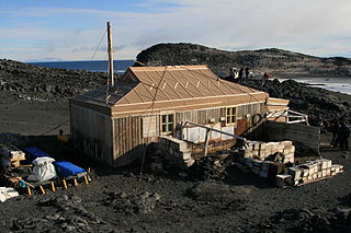
Cape Royds is a dark rock cape forming the western extremity of Ross Island, facing on McMurdo Sound, Antarctica. It was discovered by the British National Antarctic Expedition (BrNAE) (1901–1904) and named for Lieutenant Charles Royds, Royal Navy, who acted as meteorologist on the expedition. Royds subsequently rose to become an Admiral and was later Commissioner of the Metropolitan Police, London. The cape is the site of Shackleton's Hut, the expedition camp of the British Antarctic Expedition, 1907–09.

The Adare Peninsula, is a high ice-covered peninsula, 40 nautical miles long, in the northeast part of Victoria Land, extending south from Cape Adare to Cape Roget. The peninsula was named by the New Zealand Antarctic Place-Names Committee (NZ-APC) for Cape Adare. The peninsula is considered the southernmost point of the Borchgrevink Coast, named for Carsten Borchgrevink (1864-1934).
Cape Akarui, also known as Cape Miho, is a rocky cape 11 miles (18 km) northeast of Cape Omega on the coast of Queen Maud Land. Mapped from surveys and air photos by the Japanese Antarctic Research Expedition, 1957–1962, and named Akarui-misaki.
Alamein Range is a range lying west of Canham Glacier, in the Freyberg Mountains of Antarctica. It was named in association with Lord Bernard Freyberg and the Second New Zealand Expeditionary Force by the Northern Party of New Zealand Geological Survey Antarctic Expedition (NZGSAE), 1963–64.
The Land Glacier is a broad, heavily crevassed glacier, about 35 nautical miles long, descending into Land Bay in Marie Byrd Land, Antarctica. It was discovered by the United States Antarctic Service (1939–41) and named for Rear Admiral Emory S. Land, Chairman of the United States Maritime Commission.
On the continent of Antarctica, the Aramis Range is the third range south in the Prince Charles Mountains, situated 11 miles southeast of the Porthos Range and extending for about 30 miles in a southwest–northeast direction. It was first visited in January 1957 by Australian National Antarctic Research Expeditions (ANARE) southern party led by W.G. Bewsher, who named it for a character in Alexandre Dumas' novel The Three Musketeers, the most popular book read on the southern journey.
Barnett Glacier is a large glacier in the Anare Mountains that flows east along the south side of Tapsell Foreland into Smith Inlet, northern Victoria Land, Antarctica.

Omega Glacier is a glacier flowing to the coast just south of Cape Omega in Queen Maud Land. Mapped from surveys and air photos by Japanese Antarctic Research Expedition (JARE), 1957–62, who gave the name.
Mount Gunter is a conspicuous mountain, 1,970 metres (6,460 ft) high, with precipitous black rock cliffs on its west side, rising at the south side of Hariot Glacier, 3 nautical miles (6 km) east of Briggs Peak, on the west side of the Antarctic Peninsula. It was first roughly surveyed by the British Graham Land Expedition in 1936–37, and was photographed by the Ronne Antarctic Research Expedition in November 1947. It was surveyed by the Falkland Islands Dependencies Survey in 1958, and was named by the UK Antarctic Place-Names Committee after Edmund Gunter, an English mathematician whose "line of numbers" (1617) was the first step toward a slide rule; in 1620 he published tables of logarithms, sines and tangents, which revolutionized navigation.
Fitton Rock is a flat-topped rock lying southeast of Cape Alexandra, off the south end of Adelaide Island. It was first charted by the French Antarctic Expedition, 1908–10, under Jean-Baptiste Charcot, and was named by the UK Antarctic Place-Names Committee in 1963 for Gordon F. Fitton, a British Antarctic Survey general assistant at Adelaide Station, 1961–62, and a member of the first party to winter on Adelaide Island.
Gibraltar Peak is a peak in Antarctica.
Stefansson Strait is an ice-filled strait 35 nautical miles long and 3 to 10 nautical miles wide, between the east coast of Palmer Land and Hearst Island, Antarctica.