
The Everglades is a natural region of flooded grasslands in the southern portion of the U.S. state of Florida, comprising the southern half of a large drainage basin within the Neotropical realm. The system begins near Orlando with the Kissimmee River, which discharges into the vast but shallow Lake Okeechobee. Water leaving the lake in the wet season forms a slow-moving river 60 miles (97 km) wide and over 100 miles (160 km) long, flowing southward across a limestone shelf to Florida Bay at the southern end of the state. The Everglades experiences a wide range of weather patterns, from frequent flooding in the wet season to drought in the dry season. Throughout the 20th century, the Everglades suffered significant loss of habitat and environmental degradation.

Chokoloskee is an unincorporated community and census-designated place (CDP) located at the edge of the Ten Thousand Islands in Collier County, Florida, United States. The population was 345 at the 2020 census, down from 359 at the 2010 census. It is part of the Naples–Marco Island Metropolitan Statistical Area.

Everglades City is a city in Collier County, Florida, United States, of which it was once the county seat. It is part of the Naples–Marco Island Metropolitan Statistical Area, which is included in the Cape Coral-Fort Myers-Naples Combined Statistical Area. The Gulf Coast Visitor Center for Everglades National Park is located in Everglades City. As of the 2020 US census, the population was 352, down from 400 in the 2010 US census.

Flamingo is the southernmost headquarters of Everglades National Park, in Monroe County, Florida, United States. Flamingo is one of the two end points of the 99-mile (159-km) Wilderness Waterway, and the southern end of the only road through the park from Florida City. It began as a small coastal settlement on the eastern end of Cape Sable on the southern tip of the Florida peninsula, facing Florida Bay. The actual town of Flamingo was located approximately 4+1⁄2 miles west of the current Flamingo campground area. All that remains of the former town are a few remnants of building foundations, and it is considered a ghost town.

Everglades National Park is an American national park that protects the southern twenty percent of the original Everglades in Florida. The park is the largest tropical wilderness in the United States and the largest wilderness of any kind east of the Mississippi River. An average of one million people visit the park each year. Everglades is the third-largest national park in the contiguous United States after Death Valley and Yellowstone. UNESCO declared the Everglades & Dry Tortugas Biosphere Reserve in 1976 and listed the park as a World Heritage Site in 1979, and the Ramsar Convention included the park on its list of Wetlands of International Importance in 1987. Everglades is one of only three locations in the world to appear on all three lists.

Marjory Stoneman Douglas was an American journalist, author, women's suffrage advocate, and conservationist known for her staunch defense of the Everglades against efforts to drain it and reclaim land for development. Moving to Miami as a young woman to work for The Miami Herald, she became a freelance writer, producing over one hundred short stories that were published in popular magazines. Her most influential work was the book The Everglades: River of Grass (1947), which redefined the popular conception of the Everglades as a treasured river instead of a worthless swamp. Its impact has been compared to that of Rachel Carson's influential book Silent Spring (1962). Her books, stories, and journalism career brought her influence in Miami, enabling her to advance her causes.

The Great Miami Hurricane of 1926 was a large and intense tropical cyclone that devastated the Greater Miami area of Florida and caused catastrophic damage in the Bahamas and the U.S. Gulf Coast in September 1926, accruing a US$100 million damage toll. The devastation wrought by the hurricane resulted in the end of Florida's land boom, and represented an early start to the Great Depression in the state. It has been estimated that a similar hurricane would cause about $235 billion in damage if it were to hit Miami in 2018.

Southwest Florida is the region along the southwest Gulf coast of the U.S. state of Florida. The area is known for its beaches, subtropical landscape, and winter resort economy.

Hurricane Wilma was the most intense tropical cyclone in the Atlantic basin and the second-most intense tropical cyclone in the Western Hemisphere, both based on barometric pressure, after Hurricane Patricia in 2015. Wilma's rapid intensification led to a 24-hour pressure drop of 97 mbar, setting a new basin record. At its peak, Hurricane Wilma's eye contracted to a record minimum diameter of 2.3 mi (3.7 km). In the record-breaking 2005 Atlantic hurricane season, Wilma was the twenty-second storm, thirteenth hurricane, sixth major hurricane, fourth Category 5 hurricane, and the second costliest.
Cape Sable is the southernmost point of the United States mainland and mainland Florida. It is located in southwestern Florida, in Monroe County, and is part of the Everglades National Park.
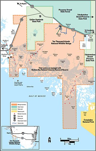
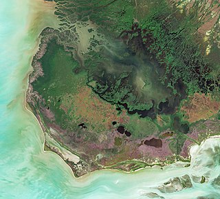
The Ten Thousand Islands are a chain of islands and mangrove islets off the coast of southwest Florida, between Cape Romano and the mouth of the Lostmans River. Some of the islands are high spots on a submergent coastline. Others were produced by mangroves growing on oyster bars. Despite the name, the islets in the chain only number in the hundreds.
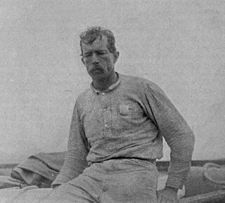
Guy Morrell Bradley was an American game warden and deputy sheriff for Monroe County, Florida. Born in Chicago, Illinois, he relocated to Florida with his family when he was young. As a boy, he often served as guide to visiting fishermen and plume hunters, although he later denounced poaching after legislation was passed to protect the dwindling number of birds. In 1902, Bradley was hired by the American Ornithologists' Union, at the request of the Florida Audubon Society, to become one of the country's first game wardens.
The indigenous people of the Everglades region arrived in the Florida peninsula of what is now the United States approximately 14,000 to 15,000 years ago, probably following large game. The Paleo-Indians found an arid landscape that supported plants and animals adapted to prairie and xeric scrub conditions. Large animals became extinct in Florida around 11,000 years ago.

A national push for expansion and progress toward the latter part of the 19th century stimulated interest in draining the Everglades, a region of tropical wetlands in southern Florida, for agricultural use. According to historians, "From the middle of the nineteenth century to the middle of the twentieth century, the United States went through a period in which wetland removal was not questioned. Indeed, it was considered the proper thing to do."
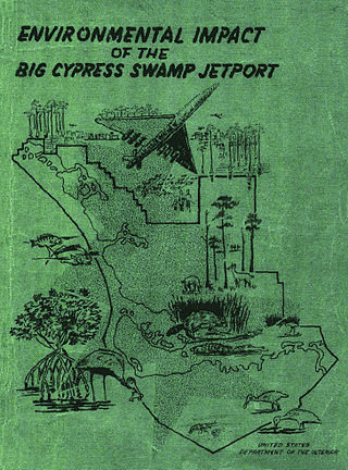
The "Environmental Impact of the Big Cypress Swamp Jetport", unofficially known as the "Leopold Report" or the "Leopold-Marshall Report", was a report authored by hydrologist Luna Leopold of the United States Geological Service for the Department of the Interior and officially released on September 17, 1969. Arthur R. Marshall, formerly of the United States Fish and Wildlife Service, helped draft the report. It is considered the first ecological impact report in the state of Florida.
Ernest Francis Coe, also "Tom Coe" was an American landscape designer who envisioned a national park dedicated to the preservation of the Everglades, culminating in the establishment of Everglades National Park. Coe was born and spent most of his life in Connecticut as a professional gardener, moving to Miami at age 60. He was enormously impressed with the Everglades and became one of several South Florida-based naturalists who grew concerned for the wanton destruction of plants, animals, and natural water flow in the name of progress and prosperity. Coe worked for more than 20 years to get Everglades National Park established, but he viewed the effort as mostly a failure. However, Oscar L. Chapman, former Secretary of the Interior, stated "Ernest Coe's many years of effective and unselfish efforts to save the Everglades earned him a place among the immortals of the National Park movement."
Friends of the Everglades is a conservationist and activist organization in the United States whose mission is to "preserve, protect, and restore the only Everglades in the world." The book Biosphere 2000: Protecting Our Global Environment refers to Friends of the Everglades as an organization that has fought to preserve North America's only subtropical wetland.

The Cape Romano Dome House was a structure consisting of six dome-shaped modules on stilts, originally built on an islet located approximately 300 feet (91 m) offshore from Cape Romano Island, south of Marco Island, in the Ten Thousand Islands of Collier County, Florida. Cape Romano Dome house was built in 1982 by retired independent oil producer Bob Lee. The home changed ownership several times, with the most recent ownership by the state of Florida since 2018. The islet was gradually eroded by successive hurricanes, and on September 28, 2022, the remaining structures above water collapsed due to Hurricane Ian.

The Everglades Wilderness Waterway is a 99-mile navigable recreational waterway route within Everglades National Park, also known as Marjory Stoneman Douglas Wilderness. It includes many interconnecting creeks, rivers, lakes and inner bays that are navigable by shallow draft powerboat, kayak or canoe. The official Wilderness Waterway route is 99 miles long, but a traveler can use various additional route options to greatly extend or slightly shorten the trip.
Spanish Indians was the name Americans sometimes gave to Native Americans living in southwest Florida and in southernmost Florida during the first half of the 19th century. Those people were also sometimes called "Muspas". Seminoles, Muscogees, Alabamas, and Choctaws were also reported to be living in southwest and southern Florida in the early 19th century. Many Native Americans were employed by and often resident at Spanish-Cuban fishing ranchos along the coast of southwest Florida. During the Second Seminole War, a band led by Chakaika that lived in the Shark River Slough in the Everglades was particularly called "Spanish Indians". The residents of the fishing ranchos and, after Chakaika's death in 1840, many people from his band, were sent west to the Indian Territory, and Spanish Indians were no longer mentioned in the historical record. Scholars long regarded the Spanish Indians as likely a surviving remnant of the Calusa people. More recent scholarship regards the Spanish Indians as Muskogean language-speakers who had settled in southern Florida in the 18th century and formed a close association with Spaniards, or were even beginning to form a Spanish-Native American creole people.
